1979 PRELIMINARY
REPORTS
Tropical
Storm Ana (TS)
Hurricane Bob (1)
Tropical Storm Claudette (TS)
Hurricane David (5)
Tropical Storm Elena (TS)
Hurricane Frederic (3)
Hurricane Gloria (2)
Hurricane Henri (1)
|
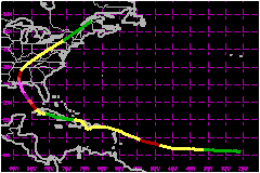
a. Synoptic History
The tropical wave from which Frederic developed left the west
African coast late on August 27th with little to distinguish it from most
other waves. By midday on August 28, however, satellite pictures showed
a rather large, circular area of convection south of the Cape Verde Islands.
Peripheral ship and satellite data indicated that a tropical depression
had formed by 0600 UTC on August 29. The depression gradually strengthened
while moving westward at 21 mph for the next 24 hours and reached tropical
storm strength near 11.5°N 36.0°W about 1200 UTC on the 30th.
Frederic continued at a remarkably steady 21 mph foward movement for the
next 48 hours while gradually turning to the northwest. Conditions appeared
ideal for Frederic to become a very intense hurricane as David
had in the same area. An eye became visible on infared satellite pictures
about 0600 UTC on September 1 and Frederic was upgraded to a hurricane
near 13°N 49°W.
About this time the outflow from David,
which had become a very intense hurricane lashing Hispaniola, began to
descend from the northwest right over Frederic, and the newborn hurricane
weakened to a tropical storm again by 0000 UTC on September 2. Frederic
gradually turned more to the west and decelerated with the weakening trend
continued until winds finally dropped below storm strength just north
of Haiti about 1800 UTC on September 6.
Frederic passed over Puerto Rico and Dominican Republic which
helped disrupt the low level wind circulation in addition to the continued
unfavourable impact of the outflow from David.
The storm actually moved towards the southwest at less than 12 mph while
southeast of the Dominican Republic, and then suddenly changed course
towards the northwest during the afternoon of September 5 in a manner
similar to David,
passing just west of Santo Domingo about 0000 UTC on the 6th.
As David
weakened over the northeastern U.S., Frederic continued slowly westward
over or just south of the Cuban coast for the next four days. Excaping
the unfavourable influence of David,
Fredreic proceeded to strengthen beginning about 100 miles east of the
Isles of Pines, Cuba about 0000 UTC on September 9. Frederic turned to
the northwest during the next 48 hours, moving at an average speed of
5 mph, and regained hurricane intensity over the western end of Cuba about
1200 UTC September 10. Factors which probably contributed to the strengthening
while the center was so close to land where the very warm sea surface
temperatures of 29-30°C, the large cyclonic envelope of the storm,
and the establishment of a large anticyclone at 200 mb over the storm.
Except for the trochoidal motion frequently observed with tropical cyclones,
Frederic moved steadily northwest and turned to the north-northwest with
increasing forward speed for the next 60 hours, the eye passing across
Dauphin Island, Alabama about 0300 UTC on September 13 and crossing the
coastline near the Mississippi-Alabama border about 1 hour later.
Frederic turned north and northeast and increased its forward speed to
23 mph during the next 24 hours, losing hurricane intensity near Meridian,
Mississippi about 1200 UTC on the 13th and becoming part of a frontal
low pressure area near the southwest corner of Pennsylvania about 1200
UTC on the 14th. The extratropical remnants of Frederic moved very rapidly
northeastward through Pennsylvania, New York and western New England during
the day and exited from northern Maine that evening.
b. Meteorological Statistics
The maximum sustianed winds in Frederic during its lifetime
were estimated at 132 mph based on aircraft reconnaissance and pressure-wind
relationships. The NOAA research aircraft reported a flight level wind
of 159 mph a short time prior to landfall, very close to that observed
at Dauphin Island. The lowest central pressure of 943 mb was reported
by Air Force reconnaissance aircraft about 1200 UTC on the 12th, when
the center was about 200 miles southeast of Mobile. However, the central
pressure reported by reconnaissance aircraft during the last 6 hours was
946 mb. Unofficial pressure reports along the coast in the eye were Dauphin
Island Sea Lab 943 mb, Grand Bay, Alabama 931 mb (appears unrealistic),
Pascagoula Civil Defense 946 mb. Meridian, Mississippi had a minimum sea
level pressure of 977 mb...the lowest in their records. Calm winds were
observed at Pascagoula for about 1 hour, and over the western end of Dauphin
Island. Calm winds were not observed in Mobile.
Frederic weakened approaching the Leeward Islands and post-analysis indicates
sustained winds had dropped below hurricane force well before the center
reached the Leeward Islands. Maximum sustianed winds were 29-35 mph with
gusts of 52-69 mph.
Frederic continued to weaken to a tropical depression while over eastern
Cuba, but regained hurricane status before leaving western Cuba. Heavy
rains occurred over the Dominican Republic for several days after the
center passed, augmenting the damage caused by David.
Rains diminished as Frederic moved over eastern Cuba, but heavy rains
and gale force winds were reported over western Cuba as the depression
reagined hurricane strength.
As Frederic strengthened over the southeastern Gulf of Mexico, winds of
52-58 mph were reported from at Dry Tortugas during the evening of the
10th and morning of 11th.
The highest winds reported in squalls and gusts are as follows: Dauphin
Island bridge 145 mph, Dauphin Island Sea Lab 137 mph before equipment
destroyed; Pascagoula Ingalls Ship Yard 127 mph; Pascagoula Civil Defense
115 mph before equipment broke; Biloxi Civil Defense, Keesler AFB, and
Gulfport Air National Guard all 98 mph; Mobile Airport and Civil Defense
both 97 mph; Pensacola Naval Air Station 95 mph; Hattiesburg, Mississippi
90 mph; Meridian, Mississippi Airport 81 mph; Pensacola Municipal Airport
78 mph; Hancock County, Mississippi 74 mph.
Gale force winds in gusts occurred near the track of Frederic throughout
eastern Mississippi, western Alabama and many sections of Tennessee, Kentucky,
southern Ohio, western portions of Ohio, New York and through western
New England. Along the coasts, gale force winds or higher occurred from
the New Orleans east area southward to the Mississippi River delta and
eastward to the Panama City area, as well as along portions of the New
England coast.
1. Storm Surge Data
Tides of 8 to 12 feet above normal were reported in the hurricane
warning area from Pascagoula, Mississippi to western Santa Rosa Island.
Tides were 12 feet at Gulf Shores, Alabama...11 feet at Fort Morgan, Alabama....9.5
feet at Gulf State Park... 12 feet just south of Mobile Tunnel and 8 feet
just north of Tunnel...10 feet on the east end of Dauphin Island and 7.5
feet on the west end...9 feet at Bayou La Batre...9 feet at Fairhope and
9 feet on western Santa Rosa Island, Florida.
2. Rainfall Data
Rainfall amounts in the Leeward Islands, Virgin Islands and
Puerto Rico was 10 inches in 12 hours in eastern Puerto Rico, 12 inches
in 24 hours in St. Thomas and 24 inches in 30 hours in St. Croix.
In the US rainfall amounts of 8 to 12 inches fell from Pascagoula to Mobile
with 4 to 6 inches through other parts of eastern Mississippi and western
Alabama, and northwestern Florida and northward through Tennessee. Amounts
of 2 to 4 inches were reported along the track all the way to New England.
No rainfall induced flooding of any consequence was associated with Frederic
in the United States.
3. Tornadoes
A few tornadoes were reported in the Virgin Islands and Puerto
Rico.
Over a dozen tornadoes were reported mostly along the Gulf coastal sections,
but they resulted in no deaths or injuries and only minor property damage.
c. Casualty and Damage Statistics
There were 9 deaths attributed to Alicia; 7 in St. Maarten
and 2 in US.
Seven deaths were reported in St. Maarten
Eleven storm related deaths have been attributed to Frederic
in the U.S., but only 2 were caused directly.
Preliminary estimates of damage is estimated at $2.3
Billion make it likely that Frederic will rank as the costliest
hurricane to ever hit the U.S. Insurance industry estimates of insured
losses stand at $750 Million.
Preliminary estimates of persosons evacuated are between 300,000 and 400,000.
Maximum Intensity For Hurricane
Frederic
29 August - 15 September, 1979
Date/Time
(UTC) |
Position |
Pressure
(mb) |
Wind Speed
(mph) |
Stage |
| Lat. (°N) |
Lon. (°W) |
| 12/1200 |
27.4 |
87.0 |
943 |
130 |
Category 3 Hurricane |
Landfall for Hurricane
Frederic
29 August - 15 September, 1979
Date/Time
(UTC) |
Pressure
(mb) |
Wind Speed
(mph) |
Stage |
Landfall |
| 03/1800 |
999 |
60 |
Tropical Storm |
St. Barthelmy |
| 04/1200 |
1004 |
50 |
Tropical Storm |
Humacao,
Puerto Rico |
| 06/0000 |
1005 |
40 |
Tropical Storm |
Santo Domingo,
Dominican Republic |
| 07/0000 |
1006 |
35 |
Tropical Depression |
eastern Cuba |
| 13/0300 |
946 |
130 |
Category 3 Hurricane |
Dauphin Island,
Alabama |
|