|
|
|
|
|||||||||||||||||||||||||
|---|---|---|---|---|---|---|---|---|---|---|---|---|---|---|---|---|---|---|---|---|---|---|---|---|---|
|
1983 PRELIMINARY
REPORTS |
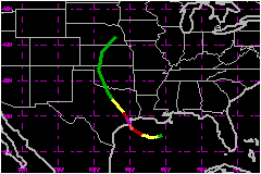
Hurricane Alicia was the first hurricane to strike the continental United States since Hurricane Allen moved over extreme southern Texas on 10 August 1980. The 3 years and 8 days between these strikes is the longest period in this century that the United States mainland has gone without a hurricane landfall. The next longest period was from 28 September 1929 to 14 August 1932. a. Synoptic HistoryThe system which was to become Hurricane Alicia formed on the extreme western end of a frontal trough which extended from off the New England coast south-westward into the central Gulf of Mexico. Surface synoptic observations and satellite pictures indicate that a meso-scale low pressure area moved off the Mississippi and Alabama coasts on 14 August with the weak trough and was likely the precursor of the system which developed into Alicia. Pressures were high over the Gulf of Mexico and remained high during the early stages of the storm's development. A ship, located less than 60 miles to the northwest of the storm's center late on August 15, reported a pressure of 1015.5 mb when the system was upgraded to a tropical storm. Two other ships located a little over 60 miles southeast and southwest of the storm center at this time reported pressures of 1016 mb or higher. With these high environmental pressures, the storm remained quite small and generated winds stronger than usually observed in storms with similar minimal central pressures. This condition persisted through August 16. Steering currents over the storm were quite weak throughout most of Alicia's lifetime over the water. However a ridge was well established to the north through August 17. Slight pressure rises were observed to the north of the storm center and falls along the Texas coast from the 15th to the 17th . The result was that Alicia drifted toward the west through midday of the 16th when the storm took a turn toward the west-northwest. This track continued through the early morning hours of August 18 when the storm took a more northerly track as the ridge to the north receded toward the east. During this period an upper level anticyclone became well established over the storm. This factor, combined with the slow movement and long period over the warm Gulf waters (greater than 29°C), resulted in the storm deepening at a nearly steady rate of 1 mb per hour over the 40 hour period before landfall. Alicia weakened rapidly after landfall and accelerated toward
the northwest over Texas then northward over western Oklahoma. The storm
started to lose tropical characteristics over Oklahoma and Kansas before
merging with a trough and losing its identity while moving toward the
northeast. b. Meteorological Statistics By hurricane standards, Alicia was only a small to medium
sized hurricane which reached minimal category three status on the Saffir/Simpson
scale at landfall. The center of Alicia moved over the coast about 25
miles southwest of Galveston, Texas at 0700 UTC on 18 August. The minimum
central pressure as determined by a NOAA reconnaissance aircraft at 0842
UTC was 962 mb. The aircraft measured a wind at flight level (5000 feet)
of 115 mph along the coast just 12 miles east of Galveston at 0736 UTC.
The wind measured 8 miles south of Galveston at 0734 UTC at flight level
was 83 mph. The strongest winds reported on land for Alicia were at Galveston
which remained just east of the eyewall. Sustained winds of 71 mph and
gusts of 98 mph at 0718 UTC with a gust of 102 mph at 0634 UTC were reported.
Winds were likely higher to the west in the eyewall and perhaps over Galveston
Bay. Aircraft observations indicate that only a 60 to 70 mile section
of the coast extending northeastward from Freeport, Texas, experienced
hurricane force winds. Surface observations, although initially sparse,
support this premise. As the storm moved inland, the winds decreased rather
rapidly. The highest winds reported at Hobby Airport, just south of Houston,
were 81 mph with gusts to 99 mph. However, the strongest winds recorded
at Houston International Airport, on the north side of Houston, were 51
mph with gusts to 78 mph. As the storm moved on inland, College Station
reported winds of 40 mph with gusts to 50 mph, and Waco observed 29 mph
winds with gusts to 43 mph as the center passed just to the east. 1. Storm Surge DataStorm tides near the time of landfall ranged from about 2
feet near Corpus Christi to more than 9 feet on the Gulf side of Galveston
and 8 feet on the bay side and down to 3.5 feet at Calcasieu Pass south
of Lake Charles, Louisiana. In addition, tides of 10 to 12 feet were estimated
along upper Galveston Bay in Baytown. 2. Rainfall DataHeavy rains caused flooded conditions over extreme southeast
portions of Texas. Some preliminary reports indicate rainfall totals near
11 inches with actual measurements of 9.95 inches at Greens Bayou and
7.75 inches at Galveston. 3. TornadoesTwenty-three tornadoes were reported to the Severe Local
Storms Forcast Center in Kansas City. Fourteen of these tornadoes occurred
between 1200 UTC August 17 and 1200 UTC August 18. These tornadoes were
concentrated in the area south of Hobby Airport and north of Galveston.
The other 9 tornadoes occurred during the next 24 hours and were scattered
over an area north of Houston to Tyler, Texas. c. Casualty and Damage StatisticsThere were 21 deaths attributed to Alicia; 21 in Texas. Although Alicia was a rather small hurricane and only a minimal
category three storm at landfall, it is one of the costliest in Texas
history. The estimated total damage of $2 Billion
is the largest dollar damage ever recorded for a hurricane striking Texas.
However, taking inflation into account, Hurricane Carla may still rank
first with a dollar damage of about $1.8 Billion
in 1983 dollars. Hurricane Carla was a much much larger and much stronger
storm than Alicia but Alicia struck a more populated area than Carla did.
If the storm the size and strength of Carla were to strike the same area
today as Alicia did, the losses would likely would 2 to 3 times larger
than for Alicia. In any case, the losses from Alicia are still staggering.
It is estimated that 21 people lost their lives as a result of the hurricane,
25 were hospitalized, 7,432 were ill or injured, 1,209 houses, 633 appartments
or condominiums and 455 mobile homes were destroyed, 2,308 houses, 919
appartments or condominiums and 281 mobile homes received major damage,
10,164 houses, 1,938 appartments or condominiums and 753 mobile homes
received minor damage. A total of 18,660 families were affected by these
damages. The total insured losses are estimated at $700
Million by the American Insurance Association and the Federal Emergency
Reports that the total Federal disaster assistance expected is about $166
Million.
Maximum Intensity For Hurricane
Alicia
Landfall for Hurricane
Alicia
| ||||||||||||||||||||||||