1985 PRELIMINARY
REPORTS
Tropical
Storm Ana (TS)
Hurricane Bob (1)
Hurricane Claudette (1)
Hurricane Danny (1)
Hurricane Elena (3)
Tropical Storm Fabian (TS)
Hurricane Gloria (4)
Tropical Storm Henri (TS)
Tropical Storm Isabel (TS)
Hurricane Juan (1)
Hurricane Kate (3)
|
Gloria effected the northeastern United States from
North Carolina through Maine. Sustained wind speeds of hurricane force
were observed at Cape Hatteras, North Carolina; Bridgeport, Connecticut;
and Blue Hill and Scituate, Massachusetts. Storm surge tiges ranged from
4 to 7 feet above predicted astronomical tide.
a. Synoptic History
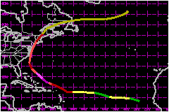
The track of Gloria begins near the Cape Verde Islands on 16
September, when a low-level circulation was observed from the European
METEOSAT satellite. Based strictly on satellite data, Gloria is estimated
to have remained near minimal storm strength for several days while travelling
toward the west to west-northwest at 17 to 23 mph across the tropical
Atlantic Ocean.
Aircraft reconnaissance began on the 21st, when the storm was
centered about 400 nautical miles east of the Lesser Antilles and moving
west at 16 mph.
A hurricane watch was issued for the northern Leeward Islands
midday on the 21st. On the next day, a reconnaissance aircraft measured
a 78-mph wind speed at 1500 feet, at a location 25 nautical miles north
of the center of the hurricane. Gloria was upgraded to a hurricane and
hurricane warnings were issued for the watch area. The hurricane changed
its direction of motion from due west to west-northwest, midday on the
22nd, and passed to the northof the Leeward Islands.
On the 24th, a hurricane was issued by the Bahamian Government for portions
of the Bahamas. By this time, the hurricane's central pressure had fallen
below 950 mb and reconnaissance winds at the 850 mb level were exceeding
105 mph. Gloria then made a turn to a northwest heading, allowing it to
miss the Bahamas.
At 25/0120 UTC, the central pressure was estimated at 919 mb, based on
extrapolation of an aircraft 700-mb height measurement. At 25/0510 UTC,
the same aircraft measured a wind speed of 145 mph at 700 mb, 10 nautical
miles east of the center. Based on this data, the maximum sustained surface
wind speed is estimated at 144 mph. During this time, Gloria was centered
at 25°N latitude, with a classical stadium-type wall cloud surrounding
the eye, and it is assumed that there was little difference between the
wind at the surface and at 700 mb.
A hurricane watch was issued of the afternoon of the 25th from South Carolina
to Virginia, when Gloria was centered about 400 nautical miles east of
Miami, Florida. Gloria gradually turned northward and began to weaken.
On the morning of the 26th, the watch was changed to a warning and by
that afternoon, the warning were extended northward to Massachusetts.
The center passed over the Outer Banks of North Carolina early on the
27th and weakened while accelerating north-northeastward. It's center
passed just offshore of Virginia, Maryland, Delaware and New Jersey, so
that the strongest winds remained over the water and these states experienced
the weaker side of the hurricane. The center came ashore over western
Long Island, about 10 hours after the North Carolina landfall, and Gloria
became extratropical over Maine at 28/0000 UTC.
As an extratropical storm, Gloria moved across eastern Canada and back
over the open waters of the far North Atlantic and gradually intensified
over a period of several days. The storm produced unusual weather over
portions of western Europe. For example, 4 October was the warmest October
day during this century in Basel, Switzerland.
b. Meteorological Statistics
The hurricane was monitered by U.S. Air Force and NOAA reconnaissance
aircraft from 21 - 27 September. There were 54 center penetrations, which
averages out to one center fix every 2.7 hours for the 6-day period. In
addition, NOAA conducted a synoptic-scale Omega dropwindsonde experiment
on the 23rd and 24th, while Gloria was centered about 200 nautical miles
north of Puerto Rico.
The center of the hurricane crossed the U.S. coast at Hatteras Island,
North Carolina and Long Island, New York.
The NWS office at Buxton, North Carolina reported a minimum pressure of
947.5 mb at 27/0536 UTC and an aircraft reported an extrapolation from
700 mb of 942 mb at 27/0542 UTC, at a location about 10 nautical miles
north of Buxton. The maximum sustained wind speed at Cape Point near Buxton
was 74 mph, out of the east-southeast, at which time the center was located
approximately 40 nautical miles to the south.
An automated station at Diamond Shoal Light, 14 nautical miles east-southeast
of Cape Hatteras, reported 98 mph, sustained, at 27/0500 UTC with a peak
gust of 120 mph. A rawinsonde was released at Cape Hatteras at 0600 UTC,
very close to the time of the eye passage. This is a rare event and the
sounding shows a warm, moist vertical profile in the lower atmosphere,
similar to the few other such observations.
Sustained wind speeds generally remained below hurricane force to the
west of the center as it accelerated toward Long Island and New England.
However, a report of 92 mph, sustained, was received from the Chesapeake
Bay Bridge and Tunnel at South island, Virginia.
The center moved ashore on western Long Island, between JFK airport and
Islip. A 74-mph wind was reported from Bridgeport, Connecticut and there
were 81-mph sustained winds in the Boston area, 60 nautical miles east
of the center. However, these winds were measured at elevations well above
sea level.
1. Storm Surge Data
Storm surge tides ranged from 4 to 7 feet above predicted
astronomical tide levels over much of the coast from North Carolina from
Massachusetts. Coastal flooding was somewhat minimized by the arrival
of peak surge during low tide at many locations. Also, both wind and surge
forcasts were higher than observed, because of the rapid weakening of
the hurricane on the 27th.
c. Casualty and Damage Statistics
There were 11 deaths attributed to Gloria; 1 in North Carolina,
6 in Connecticut, 2 in Rhode Island and 2 in New Hampshire.
Wind damage was greater on the east side of the hurricane and
resulted in downed trees causing extended power outages for hundreds of
thousands of people in the northeast U.S. To the west of the center, from
Virginia through New Jersey, the strongest winds were from the west to
northwest....after the center had passed. Beach erosion and coastal flooding
were severe along portions of the North Carolina Outer Banks. Considerable
flooding also occurred in Pamlico Sound after the center passed. Significant
beach erosion was reported from Maryland, Delaware, New Jersey, Connecticut
and Rhode Island.
The American Issurance Association has estimated insured property damage
in 13 states at $340 Million. Ratios between
total damage estimates and insured damage have ranged from 2 to 5 for
previous hurricanes. Therefore the total damage for Gloria is estimated
at $900 Million.
Maximum Intensity For Hurricane
Gloria
16 September - 02 October, 1985
Date/Time
(UTC) |
Position |
Pressure
(mb) |
Wind Speed
(mph) |
Stage |
| Lat. (°N) |
Lon. (°W) |
| 25/0120 |
25.1 |
70.9 |
919 |
145 |
Category 4 Hurricane |
Landfall for Hurricane
Gloria
16 September - 02 October, 1985
Date/Time
(UTC) |
Pressure
(mb) |
Wind Speed
(mph) |
Stage |
Landfall |
| 27/0530 |
942 |
105 |
Category 2 Hurricane |
Hatteras Island,
North Carolina |
| 27/1600 |
961 |
85 |
Category 1 Hurricane |
Long Island,
New York |
|