1985 PRELIMINARY
REPORTS
Tropical
Storm Ana (TS)
Hurricane Bob (1)
Hurricane Claudette (1)
Hurricane Danny (1)
Hurricane Elena (3)
Tropical Storm Fabian (TS)
Hurricane Gloria (4)
Tropical Storm Henri (TS)
Tropical Storm Isabel (TS)
Hurricane Juan (1)
Hurricane Kate (3)
|
a. Synoptic History
High pressure surface and aloft dominated the fall weather
of 1985 across the southeastern U.S while a major trough persisted over
the southwestern states. As a result, with the exception of a brief cool
front, no cold weather had been able to penetrate the Gulf, Caribbean
nor the southwest North Atlantic south of 32°N prior to the advent
of Kate. Therefore, when the tropical wave which ultimately became Kate
commenced to develop just northeast of the Virgin Islands, weather conditions
were more like one would expect to find in late September or early October
rather than mid November with sea surface temperartures near 27°C,
high pressure surface and aloft dominated the eastern U.S. and western
Atlantic which provided the blocking mechanism to force the developing
system (Kate) toward the west.
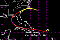
Development of Kate began just northeast of the Virgin Islands
when a weak tropical wave began to interact with a 200 mb trough on 13
- 14 November. By the time Air Force reconnaissance investigated the area
on 15 November, the system had already attained tropical storm force winds
and was named Kate. On 16 November the 200 mb trough developed a cut off
closed circulation and by 17 November accelerated to the southwest in
advance of Kate's circulation. Meantime a large 200 mb anticyclone located
over the Florida Straits on 16 November built northeastward and placed
Kate in an excellent outflow pattern between the anticyclone and the southwest
moving upper cold low. The tropical storm responded to this favourable
pattern and intensified to hurricane strength by 1800 UTC on 16 November
and to a 967 mb hurricane by 0000 UTC 19 November as the hurricane moved
westward through the extreme southeast Bahamas.
By 0600 UTC 19 November the eye of Kate made contact with the
north central cuban coast. Satellite pictures showed an excellent view
of Kate's well structured eye as the center moved onshore. Even though
the majority of the eye wall cloud moved over land and continued to track
inland for a period of 12 hours, satellite pictures indicated that Kate
maintained an excellent eye definition during the entire time. Air Force
reconnaissance's data indicate Kate weakened from 967 mb, just prior to
landfall, to 976 mb just after it emerged from the Cuban coast just east
of Havana.
By 0000 UTC 20 November Kate had cleared the island of Cuba and the center
had passed as close as 85 miles south-southwest of Key West. It was during
this next 24 hour period that Kate reintensified at a rate of nearly 1
mb per hour from a 972 mb at 0000 UTC 20 November to 953 mb (lowest pressure)
at 2000 UTC 20 November.
At 0000 UTC 20 November a frontal trough, moving from the west, was located
over the upper Mississippi valley and extended southwest into Texas. As
Kate moved off the Cuban coast it began a turn toward the northwest in
response to the advancing frontal system. By the Kate had reached the
central eastern Gulf if was moving toward the north and commenced to move
over cooler waters. The combination of cooler gulf waters (22°C just
off the Gulf north coast) and increasing southwest shear from the approaching
frontal trough caused Kate to begin weakening once the hurricane moved
north of latitude 26.5°N. By the time it reached the coast at Mexico
Beach, Florida, Kate had weakened to 967 mb.
Maximum winds at landfall were near 98 mph. Kate continued to track toward
the northeast, passing just to the west of Tallahassee. The hurricane
was downgraded to a tropical storm by 1000 UTC on 22 November as it continued
moving toward the northeast across south central Georgia. Kate continued
to lose strength after in emerged over the Carolina coastal waters late
in the day on 22 November. Sea surface temperatures along the coast were
in the upper teens celcius and even the Gulf Stream was a mild 24°C.
Also strong shear continued over the system. Therefore, Kate continued
to weaken and became extratropical on 23 November as it turned toward
the east-southeast. The remnants of Kate produced wind gusts of 26 mph
at Bermuda as it passed just to the north of the island on the morning
of 24 November.
b. Meteorological Statistics
Maximum winds observed from Cuban stations in or near the track
were 75 mph from Sagua La Grande Las Villas while Varadero reported 69
mph from the east with gusts to 104 mph. Havana had north and west winds
of 58 to 69 mph.
Maximum sustained winds at WSO Key West were 47 mph with peak gusts of
69 mph. However unofficial wind gusts from a sheriff's office (annemometer
reportedly on roof of third flood building) was 104 mph.
The center of Kate passed very close to the NOAA buoy in the eastern Gulf
about the same time Air Force reconnaissance was in the hurricane. Pressure
measurements from the dropsonde and the data Buoy were extremely close.
Aircracft measured the central pressure of Kate at 956 mb while the data
Buoy had a reading of 957 mb. During this time period the aircraft was
measuring top winds of 115 mph to 125 mph while the data Buoy reported
an 8 minute average wind speed of 108 mph with a peak gust of 136 mph.
1. Storm Surge Data
Storm surge tides as high as 11 feet were recorded at Cape
San Blas, Florida.
c. Casualty and Damage Statistics
Little structual damage occured in the state capital of Tallahassee,
howver, numerous trees were downed extensive power outrage throughout
the area.
The damage of Kate in the Apalachicola area was extensive due
to the ruination of the Oyster Industry. Earlier in the year Elena
did considerable damage to the oyster beds in the Apalachicola area. However,
the final blow was dealt by kate. Death toll for the hurricane stands
at 6.
Total damage bill for Kate is estimated at $300
Million.
Maximum Intensity For Hurricane
Kate
15 - 23 November, 1985
Date/Time
(UTC) |
Position |
Pressure
(mb) |
Wind Speed
(mph) |
Stage |
| Lat. (°N) |
Lon. (°W) |
| 20/2000 |
26.2 |
86.2 |
953 |
120 |
Category 3 Hurricane |
Landfall for Hurricane
Kate
15 - 23 November, 1985
Date/Time
(UTC) |
Pressure
(mb) |
Wind Speed
(mph) |
Stage |
Landfall |
| 19/0600 |
967 |
110 |
Category 2 Hurricane |
North-Central Cuba |
| 21/2230 |
967 |
100 |
Category 2 Hurricane |
Mexico Beach,
Florida |
|