|
|
|
|
|||||||||||||||
|---|---|---|---|---|---|---|---|---|---|---|---|---|---|---|---|
|
1997 PRELIMINARY
REPORTS |
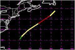
Bill became the first hurricane of the 1997 season. It spent its brief life over waters the north Atlantic Ocean. a. Synoptic HistoryBill developed from a large upper-level low that separated
from the mid-oceanic trough northeast of Puerto Rico. On 7 July, satellite
images indicate that cloudiness and showers associated with the upper-
level low began to increase and although surface pressures were quite
high north of Puerto Rico there was a small perturbation of the wind field
and a trough at the surface. A low pressure center formed from the trough
just east of the Bahamas and moved toward the west-northwest. The upper-level
low moved southwestward into the Caribbean Sea resulting in a decrease
in the wind shear over the surface low. The first indications that a tropical
depression might be forming was a 24-hour pressure drop of near 3 mb in
the eastern Bahamas as the area of low pressure approached. Convection
then gradually became organized and it is estimated that a tropical depression
formed near 0600 UTC 11 July. By then, the tropical cyclone was already
moving northeastward ahead of a cold front located over the eastern United
States. The system reached tropical storm status by 1200 UTC on the same
day. A reconnaissance plane was dispatched to the area early on
11 July and measured 52-mph at 700 feet to the southeast of the center.
The minimum surface pressure was 1013 mb, which is not very low for a
tropical cyclone but environmental pressures were also high. The prevailing
pressure gradient would support tropical storm force winds. Bill continued moving toward the northeast about 23 to 29
mph and reached cool waters. An eye was depicted on high resolution visible
images at 1300 UTC 12 July, suggesting that Bill reached hurricane strength
in spite of the cool waters. A special Dvorak classification from the
Tropical Analysis and Forecast Branch (TAFB) indicated that Bill reached
its peak intensity of 75 mph at 1500 UTC 12 July. The minimum pressure
estimated at that time was 986 mb. Thereafter, Bill became absorbed by
a frontal system and was no longer identifiable by 0600 UTC 13 July. b. Meteorological StatisticsThe best track pressure and wind curves as a function of
time are shown in Fig. 2 and 3 (10K GIF) and are based on reconnaissance
and surface observations, satellite intensity estimates from TAFB, the
Satellite Analysis Branch (SAB) and the Air Force Global Weather Center
(AFGWC). The latter reported an intermittent eye feature as early as 0415
UTC 12 July. c. Casualty and Damage StatisticsThere are no reports of casualties or damage associated with Bill.
Maximum
Intensity For Hurricane Bill
| ||||||||||||||