|
|
|
|
|||||||||||||||||||||||||||||||||||
|---|---|---|---|---|---|---|---|---|---|---|---|---|---|---|---|---|---|---|---|---|---|---|---|---|---|---|---|---|---|---|---|---|---|---|---|
|
1997 PRELIMINARY
REPORTS |
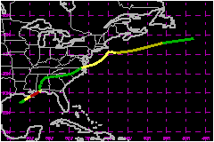
Danny was a slow-moving category one hurricane on the Saffir/Simpson Hurricane Scale that made landfall near the mouth of the Mississippi River and in the Mobile Bay area. It produced enormous amounts of rain over extreme southern Alabama. a. Synoptic HistoryLike tropical cyclones Ana, Bill,
and Claudette, Danny came from a weather
system of non-tropical origin. On 13 July, a broad upper-tropospheric
trough over the southeastern United States triggered a cluster of thunderstorms
over the lower Mississippi River valley. This area of convection drifted
southward over the north-central Gulf of Mexico coastal waters, and appears
to have contributed to the formation of a small, weak surface low near
the coast of Louisiana on the 14th. Over the next couple of days, the cyclonic circulation expanded
somewhat over the northern Gulf. However, surface winds remained quite
weak and the associated deep convection was not persistent or well-organized.
By 1200 UTC on 16 July, deep convection became a little better organized
near the center and the system began to resemble a tropical cyclone. Initial
Dvorak satellite classifications were given. Observations from oil rigs
and NOAA data buoys at the same time showed that the circulation had become
well-defined. These surface and near-surface data indicated that maximum
winds were near 29 mph. It is estimated that Tropical Depression Four
formed at this time, centered about 125 nautical miles south of the coast
of southwestern Louisiana. Development of the system was rather slow until around 1200
UTC 17 July. Starting around that time, the amount and organization of
deep convection increased dramatically. Data from an Air Force Hurricane
Hunter plane "fixing" the center of the cyclone at 1448 UTC on the 17th
suggested that the cyclone had reached tropical storm strength. Satellite
intensity estimates showed an increase from a T2.0 to T3.0 on the Dvorak
scale in the interval from 1200 to 1800 UTC. Danny continued to strengthen,
and was a hurricane by 0600 UTC on the 18th. By this time the center was
nearing the Mississippi River delta. While over the northern Gulf coastal area, Danny was generally
located on the southeast side of a very weak mid-tropospheric trough that
was oriented from east-northeast to west-southwest. In effect, Danny was
"sandwiched" between two high pressure areas. Consequently, the cyclone
moved quite slowly in a generally east-northeastward direction. It is
rather rare for Gulf of Mexico tropical cyclones to move in this direction
during the month of July. At times, the forward motion slowed nearly to
a halt. Hurricane Danny made its first landfall, just northwest of
the Mississippi River delta near the towns of Empire and Buras, early
on 18 July. Danny was a very small hurricane, and significant effects
were confined to the area immediately around the eye. Reports from the
Hurricane Hunters indicated a radius of maximum winds of eight or nine
nautical miles. Communities from Port Sulphur southeastward to Venice,
Louisiana probably experienced hurricane force winds (the Venice ASOS
site lost power after reporting wind gusts to 44 mph a couple of hours
before the closest approach of the hurricane's center). After passing over extreme southeastern Louisiana, the center
of Danny was back over the Gulf of Mexico, south of the coast of Mississippi,
during the day on 18 July. There was a little more strengthening, and
Danny reached its peak intensity of 81 mph with a minimum central pressure
of 984 mb. The slow-moving hurricane wobbled to the east, then north-northeastward,
bringing the eye to the mouth of Mobile Bay, near Fort Morgan, Alabama,
just before dawn on the 19th. The eyewall and western edge of the eye
passed over Dauphin Island, where sustained hurricane-force winds and
torrential rains were experienced. After drifting over extreme southern
Mobile Bay, the center plodded eastward, practically stalled, and finally
crossed the coast on the southeast shore of the bay near Mullet Point,
Alabama around midday on the 19th. Danny continued to move erratically,
toward the southeast over extreme southeast Alabama, while weakening to
a tropical storm by 0000 UTC on the 20th. The weakening cyclone then turned
northward, passing over the extreme northwest Florida panhandle. Danny,
weakened to a depression by 1800 UTC on the 20th, moved north to northeastward
over Alabama for two days. Satellite images showed that Danny, although very weak at
the surface, still had a well-defined cyclonic cloud signature as it moved
eastward over northern Georgia and South Carolina on 22-23 July. The low
pressure system moved east-northeastward over North Carolina on the morning
of the 24th. Around midday, as the center neared the Atlantic seaboard
near the North Carolina/Virginia border, the cyclone began strengthening
-- while accelerating in forward speed. The fact that Danny was re-intensifying
while still partially over land suggests that it may have been deriving
energy from a baroclinic source. A front was situated just to the north
of the cyclone around this time. Winds around Danny were already back
to tropical storm force as the center moved back over water around 1900
UTC on the 24th. Just when it looked as if it were racing safely away from
the coast, the storm turned north-northeastward, and slowed dramatically,
as it appeared to be drawn in toward a middle- to upper-tropospheric cyclone
over the northeastern United States. This motion brought Danny to about
25 nautical miles southeast of Nantucket Island, Massachusetts, around
0000 UTC 26 July. After buffeting southeastern Massachusetts, Danny lost
its remaining tropical characteristics, and turned out to sea -- for good.
The cyclone was absorbed in a frontal zone over the north Atlantic by
1800 UTC on 27 July. b. Meteorological StatisticsThe Hurricane Hunters flew a total of 11 missions into Danny,
10 in the Gulf of Mexico ( just inland along the Gulf coast) and one in
the Atlantic. Just prior to landfall near the mouth of the Mississippi
River early on 18 July, the Hurricane Hunters reported maximum flight-level
(1500-foot) winds of 92 mph. At about the same time, 10-minute average
winds of 63 mph, with gusts to 95 mph, were reported at Grand Isle, Louisiana.
Maximum winds reported by the Hurricane Hunters were 94 mph (at 1500 feet)
at 1449 UTC 18 July. The minimum central pressure recorded by the aircraft
was 984 mb at 2325 UTC on the 18th, and again at 1142, 1259, and 1410
UTC on the 19th. The Dauphin Island C-MAN site, on the west end of the island,
measured 10-minute average winds of 75 mph at 1145 UTC 19 July and gusts
to 101 mph 21 minutes earlier. Interestingly, the Mobile WSR-88D radar
showed that around these times the strongest eyewall convection was occurring
in this vicinity over the southwest quadrant of the hurricane. At 1139
UTC, aircraft reported maximum winds of 74 mph at the 850 mb flight level
in the southwest quadrant. Thus, surface winds and flight-level
winds were about the same in this highly convective regime of the
hurricane. 1. Storm Surge DataStorm tides of generally two to five feet occurred from the
Florida/Alabama border to Dauphin Island. A maximum storm tide of 6.54
feet was reported along Highway 182W, about midway between Gulf Shores
and Fort Morgan. This exceptionally high water mark may have been the
combined result of storm surge and wave action. In the upper part of Mobile
Bay, offshore winds blew water out of the bay so that tides were two feet
below normal. Observers reported that the bay had never been so low and
that, except for the river channels, one could have walked across the
bay. 2. Rainfall DataTrue to form for a slow-moving hurricane, rainfall totals
over extreme southern Alabama were gigantic. Doppler radar estimates suggested
maximum storm total precipitation amounts to around 43 inches near Dauphin
Island. Recent studies indicate that a new reflectivity vs. rainfall relationship
for tropical cyclones, used with the Mobile radar, gives a rather accurate
estimate of the actual precipitation. A rainfall total of 36.71 inches
was measured at the Dauphin Island Sea Lab observing site. To the author's
knowledge, this is the largest hurricane-related rainfall ever recorded
in the state of Alabama, and one of the largest ever measured in the United
States. Experience has shown that in the high wind regime of a hurricane,
rain gauges do not capture all of the rainfall; so, this amount is probably
an underestimate of the total. Fortunately, most of the extreme precipitation
amounts occurred in areas near the coast or over water, near southwestern
Mobile Bay. This helped to limit the amount of flooding, which would have
been disastrous if rains of such magnitude had occurred farther inland.
Nonetheless, there was some significant inland flooding along the path
of Danny, notably in Charlotte, North Carolina, where rainfall totals
of 8 to 12 inches where recorded. The resulting floods caused three deaths
(see next section). 3. TornadoesDanny spawned tornadoes in Orange Beach and Alabama Port,
Alabama. Farther inland, a severe thunderstorm cell in Danny's circulation
produced five tornado touchdowns in Lexington (causing one fatality; see
next section), Richland (two touchdowns), Kershaw, and Chesterfield Counties
of South Carolina. A small, weak tornado was reported in Abbeville County,
South Carolina. A few hours before Danny moved into the Atlantic, tornadoes
touched down in the South Norfolk section of Chesapeake, Virginia and
also in downtown Norfolk. c. Casualty and Damage StatisticsThere were 4 deaths attributed to Danny; 2 in North Carolina,
1 in Alabama and 1 in South Carolina. According to the American Insurance Services Group, insured losses from Danny were about $60 Million. The National Hurricane Center estimates around $100 Million in total damage.
Maximum Intensity For Hurricane Danny
Landfall for
Hurricane Danny
| ||||||||||||||||||||||||||||||||||