|
|
|
|
|||||||||||||||
|---|---|---|---|---|---|---|---|---|---|---|---|---|---|---|---|
|
1997 PRELIMINARY
REPORTS |
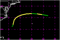
a. Synoptic HistoryThe frontal system that swept Hurricane
Bill northeastward across the western Atlantic also generated a frontal
low a few hundred miles to the east of Georgia and South Carolina on 11
July. Over the following two days the low moved little and gradually acquired
a closed, low-level circulation that was independent of the frontal band
dissipating in its vicinity. The low is estimated to have become a tropical
depression at 0600 UTC on the 13th, while located about 275 nautical miles
to the south-southeast of Cape Hatteras, North Carolina. The depression became Tropical Storm Claudette 12 hours later,
based on 52-58 mph winds measured at a flight level of 750 ft during
the first reconnaissance aircraft mission in the system. About this time,
banding of convection increased enough for Dvorak T-numbers to reach 2.5.
This development came despite some southerly to southwesterly wind shear
which prevented Claudette from developing more than a weak anticyclone
aloft. Deep convection was episodic with most activity occurring
during the night hours. Satellite classifications and aircraft data suggest
that Claudette retained 30-46 mph winds from the 13th-16th. During that
period, Claudette initially moved northward, but then was accelerated
toward the east by the flow ahead of an approaching frontal system. On
the 16th, Claudette merged with the front, its center once again becoming
a frontal low. The extratropical low moved generally toward the east over
the following week. Satellite pictures suggest that it dissipated near
the Azores Islands on the 23rd. b. Meteorological StatisticsPosition and intensity estimates were obtained from analyses
of satellite pictures by NOAA's Synoptic Analysis Branch (SAB) and Tropical
Analysis and Forecast Branch (TAFB), and by the Air Force Global Weather
Center (AFGWC). The analyses also included observations from the reconnaissance
aircraft flights taken by the Air Force Reserve. There were no land, ship or buoy reports of tropical storm
force winds associated with Claudette. c. Casualty and Damage StatisticsClaudette did not directly affect land and no reports of casualties or damages were received.
Maximum
Intensity For Tropical Storm Claudette
| ||||||||||||||