|
|
|
|
|||||||||||||||
|---|---|---|---|---|---|---|---|---|---|---|---|---|---|---|---|
|
1997 PRELIMINARY
REPORTS |
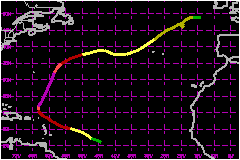
Erika became a category three hurricane on the Saffir/Simpson Hurricane Scale, was the only named tropical cyclone of 1997 to form from a tropical wave at low latitudes, and just missed the islands of the northeastern Caribbean Sea. a. Synoptic HistoryErika was first tracked as a tropical wave and large area
of disturbed weather moving westward from Africa to the eastern tropical
Atlantic Ocean on 31 August. The system immediately showed evidence of
a large-scale low-level cyclonic turning. But it was not until 3 September,
when located about 1000 nautical miles east of the Lesser Antilles, that
a low-level center was defined well enough for it to be upgraded to a
tropical depression. The depression quickly strengthened to tropical storm Erika
on the 3rd and to a hurricane on the 4th as it moved mostly west-northwestward
at 17 mph or so under the steering control of a well-established subtropical
high pressure ridge. There was a hint of an eye as infrared satellite
imagery showed a warm spot embedded in the deep convection over the center
early on the 4th, but visible satellite imagery later showed a partially
exposed low level center. The strengthening of Erika to a hurricane, based
on drifting buoy data east of the Lesser Antilles, occurred under what
appears to be an unfavorable shearing situation. However, deep convection
soon reappeared over the center and strengthening continued, while Erika
moved toward the west-northwest. On the 5th through the 8th, the forward motion gradually
decreased as the center of the hurricane came within about 75 nautical
miles to the northeast of the northeastern-most Lesser Antilles...just
far enough away for hurricane conditions to miss these islands. By the
8th, Erika had turned toward the north with a movement of only 8 mph as
an amplifying trough over the western north Atlantic eroded the subtropical
ridge and weakened the nearby steering currents. Erika reached its peak intensity of 127 mph at 1800 UTC on
the 8th and retained this wind speed for a period of about 24 hours, while
it was located 300 nautical miles north of the Caribbean islands and started
to accelerate northward. Reconnaissance aircraft and satellite imagery
indicated an eye diameter of about 30 nautical miles during this time
and the hurricane's radius of tropical storm force wind speeds expanded
to 250 nautical miles. The hurricane passed about 300 nautical miles east of Bermuda
on the 10th and became embedded in westerly steering currents which caused
a turn toward the east-northeast on the 11th and 12th. By this time, weakening
had commenced due to a combination of cool sea surface temperatures and
westerly winds aloft. Winds dropped below hurricane force on the 12th.
However, Erika periodically retained deep convection near its center for
another four days along with wind speeds between 52 and 69 mph while it
moved mostly eastward across the north Atlantic. The center passed very
near the western-most Azores on the 15th and tropical storm conditions
were experienced in these islands. Erika then lost most of its deep convection
and became extratropical by the 16th. It continued moving northeastward
for several more days, followed by dissipation on the 20th while located
about 200 nautical miles southwest of Ireland. b. Meteorological StatisticsThe NOAA Gulfstream high-altitude jet flew missions which
resulted in data available for the 0000 UTC NCEP model runs on the 4th
and 5th. This was when Erika was threatening the Caribbean islands and
several days in advance of the recurvature across the north Atlantic.
This data set provides an opportunity to evaluate the impact of synoptic-scale
high-altitude dropsonde missions. A NOAA drifting data buoy reported a 69-mph wind speed at
1600 UTC on the 4th, when Erika was located some 500 nautical miles east
of the Lesser Antilles. The best track takes Erika to a hurricane at 1800
UTC based on this report, although there is considerable uncertainty about
the accuracy of drifting buoy wind measurements as well as the method
used to adjust the wind speed to the 10 meter level. There were no reports of tropical storm force or higher sustained
winds from the islands of the northeastern Caribbean as Erika passed nearby.
The highest report received was 37 mph sustained wind speed with gusts
to 47 mph from St. Thomas in the U.S. Virgin Islands on the 7th, when
Erika was centered 125 nautical miles north-northeast of this location.
There were, undoubtedly, stronger winds over the higher terrain of the
islands from the Virgin Islands east and southward through Antigua and
Montserrat. NOAA research aircraft dropped GPS dropsondes into the eye
wall on the 7th and 8th, as Erika was strengthening to its maximum intensity.
While maximum 700-millibar flight level winds were near 127 mph late on
the 8th, the vertical wind profile obtained near the eye wall showed that
wind speeds between 150 and 1500 meters reached nearly 50 percent higher.
The wind speed from this dropsonde nearest to the surface (approx. 15
meters) was 135 mph and the best track surface wind speed of 127 mph is
based on this data. The highest sustained surface wind report seen from the Azores
was 30 mph with a gust to 45 mph at Lajes Air Base at 1900 UTC on the
15th as Erika's center was passing 180 nautical miles to the northwest.
A report from Flores at 2300 UTC on the 15th gave a gust to 87 mph. A
report from Lajes showed a gust to 105 mph from a 200-foot tower.
1. Rainfall DataThe largest rainfall total reported from the Virgin islands
is 3.28 inches from St. Thomas c. Casualty and Damage StatisticsThere were 2 deaths attributed to Erika; 2 in Puerto Rico. The passage of the hurricane caused the lower-tropospheric winds to blow from the southwest and advect a cloud of falling ash over Antigua from the active volcano in Montserrat.
Maximum Intensity For Hurricane Erika
| ||||||||||||||