1993
PRELIMINARY REPORTS
Tropical
Storm Arlene (TS)
Tropical Storm Bret (TS)
Tropical Storm Cindy (TS)
Tropical Storm Dennis (TS)
Hurricane Emily (3)
Hurricane Floyd (1)
Hurricane Gert (2)
Hurricane Harvey (1)
|
a. Synoptic History
A siege of unsettled weather over the western Caribbean Sea
and Central America preceded Arlene's formation. As early as 9 June, an
area of clouds and scattered deep convection was noted on satellite pictures
near the east coasts of Nicaragua and Honduras. The activity spread slowly
northwestward and increased a little in areal coverage over the following
week. During that period, upper-level winds over the northwestern Caribbean
Sea and the Gulf of Mexico were generally from the west or northwest,
creating a vertical wind shear that was not favourable for the development
of a tropical cyclone.
On the 16th, however, a mid- to upper-level low began to develop over
the Bay of Campeche. Downstream, the flow aloft became more anticyclonic
over the Yucutan peninsula and the northwest Caribbean Sea. In addition,
on that date, a tropical wave neared the Yucutan peninsula from the east-southeast.
The net effect of these changes was for the convective activity to expand
west-northwest into an area where the upper-level circulation was somewhat
more conductive to the development of a tropical depression. Analysis
of surface data suggests that, by late on the 16th, a 1008 mb low formed
over the Yucutan peninsula.
A U.S. Air Force Reserve's reconnaissance plane found only a broad area
of low pressure in that area at midday on the 17th. However, satellite
pictures a few hours later showed convective bands developing just offshore
over the south-central Gulf of Mexico, and it is estimated that 0000 UTC
on the 18th the system became Tropical Depression Two. The depression
was centered between the low aloft to the southwest, and a deep-layer-mean
high to the northeast. The associated steering flow moved the depression
toward the northwest at about 6 mph.
The center of the depression remained near the eastern edge of the low
aloft, in an area of moderate southwesterly vertical wind shear which
apparently precluded strengthening of the depression. The low-level center
stayed diffuse, with satellite images occasionally showing separate weak
low-level cloud swirls in that area. Indeeed, the reconnaissance mission
late on the 18th measured 1006 mb as the lowest pressure within a broad
area for which they could not make a center "fix". By that time,
satellite pictures suggest that the upper-level shear over the diffuse
center had been further increased by a southwesterly outflow jet cutting
across the southwestern Gulf of Mexico from easteren North Pacific Tropical
Storm Beatriz.
In the meantime, on the 18th, convection became more concentrated in a
band located about 150 to 200 nautical miles to the southeast through
northeast of the depression center. Over the next 24 hours, the band cyclonically
wrapped further around the center, so that by early on the 19th, a comma-shaped
band extended from well northwest through north through southeast of the
center. It is within that northwestern extension of the convective band
that satellite pictures and reconnaissance data indicae a new and dominant
(1000 mb) low-level center of circulation formed near 1200 UTC on the
19th. It is the second center (located about 100 nautical miles northeast
of the original center) that is designated in the "best track"
as Tropical Storm Arlene at 1200 UTC.
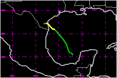
The new center initially moved northwestward at about 6 mph, but then
nearly stalled when an eastward-moving short-wave trough passed by to
the north. The forward motion then became westward at a couple of mph.
Arlene made landfall over Padre Island, about 40 nautical miles south
of Corpus Christi, near 0900 UTC on the 20th and weakened to depression
strength shortly thereafter. The system remained a tropical depression
through 0600 UTC on the 21st. A low- to mid-level remnant circulation
could be detected for another day or two over the lower Rio Grande River
valley of southern Texas and northeastern Mexico.
b. Meteorological Statistics
Although maximum sustained wind speeds near Arlene's center
are estimated to have been about 40 mph for the 18 hours ending with landfall.
somewhat stronger winds were in the convective band located well to the
east of the circulation center. Sustained wind speeds of 46 mph to 52
mph were reported between 1100 and and 2000 UTC by ship C6JP2 (name
unknown) and several platforms over the north-central Gulf of Mexico.
Similar wind speeds in that vicinity had been encountered by the reconnaissance
aircraft at a flight level of 1500 feet. The distant wind maximum and
the association of the tropical cyclone with the nearby low aloft indicate
that Arlene's structure had some subtropical cyclone characteristics.
Reconnaissance aircraft observed a central pressure of 1000 mb on seven
consecutive of Arlene. This is the estimated minimum pressure of the storm.
The pressure at landfall is estimated at 1001 mb.
1. Storm Surge Data
Arlene generated storm tides of up to 4 feet along the Texas
coast. The storm tide breached sections of Padre Island and caused local
flooding on the mainland
2. Rainfall Data
Heavy rain fell for several days over Central America from
the weather system that eventually became Arlene. Heavy rains also occurred
over Mexico. Arlene brought large accumulations of rain and local floods
to the area extending inland about 50 nautical miles from the Texas coast.
Locally heavy rain, from a combination of Arlene and a frontal system,
also occurred in northeast Texas, Louisiana, and Arkansas. The town of
Henderson, Texas reported the largest total, 14.82 inches.
c. Casualty and Damage Statistics
There were 26 deaths attributed to Arlene; 20 in El Salvador,
5 in Mexico and 1 in Texas.
The prolonged rains over Central America prior to Arlene becoming a tropical
cyclone reportedly caused a landslide in El Salvador that killed 20 people.
In Mexico, floods from Arlene killed 5 people( 4 in the state of Yucutan
and 1 in the state of Campeche.) There was 1 flood-related fatality reported
in Henderson, Texas. Damage in Campeche was reported at $33
Million. Flooding from rainfall was also reported in Texas, Louisiana,
and Arkansas. The Texas Division of Emergency Management estimated $22
Million damage to homes, businesses, and infrastructure in that
state. Crop losses were not quantified.
The storm storm tide removed about 6 to 12 inches of sand from some beaches
along the lower Texas coast. Extensive tidal flooding was reported on
the lower and middle Texas coast as well as along beach access roads.
Beach erosion was also reported in southwestern Louisiana.
The threat of flooding prompted the evacuation of about 15 people from
summer homes along Magnolia Beach and Indianola, Texas.
Maximum Intensity For Tropical
Storm Arlene
18 - 21 June, 1993
Date/Time
(UTC) |
Position |
Pressure
(mb) |
Wind Speed
(mph) |
Stage |
| Lat. (°N) |
Lon. (°W) |
| 19/1200 |
25.9 |
95.9 |
1000 |
40 |
Tropical Storm |
Landfall for Tropical
Storm Arlene
18 - 21 June, 1993
Date/Time
(UTC) |
Pressure
(mb) |
Wind Speed
(mph) |
Stage |
Landfall |
| 20/0900 |
1001 |
40 |
Tropical Storm |
Padre Island,
Texas |
|