1993
PRELIMINARY REPORTS
Tropical
Storm Arlene (TS)
Tropical Storm Bret (TS)
Tropical Storm Cindy (TS)
Tropical Storm Dennis (TS)
Hurricane Emily (3)
Hurricane Floyd (1)
Hurricane Gert (2)
Hurricane Harvey (1)
|
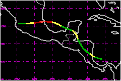
Gert was a large sprawling system which spent much of its lifetime
near Central America and Mexico. It hit mainland Mexico with maximum
sustained winds near 98 mph, but its biggest impact was caused by very
heavy rainfall in Nicaragua, Honduras and especially in Mexico.
a. Synoptic History
A tropical wave passed off the west coast of Africa on 5
September well to the south of Dakar. The wave moved rapidly westward
(near 23 mph) across the tropical Atlantic for the next several days at
rather low latitudes, causing some enhancement of convection in the Intertropical
Convergence Zone. The cloudiness associated with the wave became a little
better organized as the system neared the Windward Islands, and a weak
surface low associated with the wave passed over Trinidad on the 11th.
Over the next couple of days, most of the system moved over the extreme
northern part of South America. It emerged over the waters of the southwest
Caribbean Sea late on the 13th. The upper tropospheric environment over
this region was apparently favourable for development, and deep convection
soon organized into curved bands. The system was classified as a T1.0
on the Dvorak scale by the NHC's Tropical Satellite Analysis and Forcast
(TSAF) unit at 1200 UTC 14 September. The tropical depression stage of
Gert begins at 1800 UTC on 14 September, about 90 nautical miles north
of the north coast of Panama.
During the early stages of its existence it was clear that Gert had a
fairly large-sized circulation. This was evident not only from satellite
imagery, but also from rawinsonde data over the western Caribbean area.
The depression strengthened to a tropical storm by 1200 UTC on the 15th,
as the associated cloud patter continued to become better organized. Development
was soon halted, as Gert's west-northwestward trek over the land mass
of Nicaragua in the vicinity of Bluefields around 1800 UTC on the 15th.
The center of Gert then began a nearly two-day northwestward trek over
the land masses of Nicaragua and Honduras. The system weakened to a depression
about six hours after moving inland over Nicaragua, but maintained enough
of a surface circulation, over land, to retain depression status for the
next 36 hours. This was at least partly attributable to the large diameter
of Gert's circulation, that was able to maintain some contact with the
adjacent Caribbean and Pacific waters.
The depression emerged over the Gulf of Honduras around midday on the
17th, and strengthened back to a tropical storm based on NHC satellite
classifications and a ship report. Gert was moving north-northwestward
at this time. The northwest and northwestward motion was apparently brought
about by a mid- to upper-tropospheric cyclone over the eastern Gulf of
Mexico. By 0000 UTC on th 18th, Gert was moving inland again near Belize
City, Belize, its time over water being of such duration that it did not
strengthen beyond minimum tropical storm intensity. A mid-tropospheric
ridge over the northwestern Guf of Mexico area forced Gert to turn back
toward the west-northwest, and Gert, having weakened back to a depression,
crossed the Yucutan Peninsula on the 18th. The center re-emerged over
water, this time over the Bay of Campeche, late on that day.
Now that the center was over relatively open waters, the opportunity for
significant strengthening existed. Gert re-intensified to a tropical storm
by 0600 UTC on the 19th, and 24 hours later it became a hurricane. The
forward motion slowed to less than 6 mph around 0000 UTC on the 20th,
which allowed more time for the center to dwell over the warm waters of
the southwest Guf of Mexico. Consequently, Gert was able to strengthen
maximum intensity of around 98 mph just before making its third landfall;
U.S. Air Force Reserve Unit reconnaissance reports indicate that the central
pressure fell to 970 mb. The eye of Gert, moving westward (or even a little
south of west), crossed the coast of mainland Mexico just to the north
of Tuxpan near 2100 UTC on 20 September. A portion of the southern eyewall
passed over Tuxpan around 2000 UTC. After moving inland, the center accelerated
westward. Gert weakened rapidly over the Sierra Madre Oriental mountains
of Mexico, and the cyclone was reduced to a tropical depression just after
0600 UTC on the 21st. However, the fast-moving circulation was able to
remain intact while crossing Mexico, and the center neared the pacific
coast of Mexico around 1800 UTC on the 21st. It emerged over the eastern
Pacific waters shortly thereafter, where it was reclassified as Tropical
Depression Fourteen_E.
b. Meteorological Statistics
No quantitive wind reports were received from Nicaragua.
Chetumal, Mexico reported winds to near 44 mph, presumably in gusts around
the time that Gert was making landfall near Belize (just to the south).
Tuxpan, Mexico reported winds to 102 mph, Poza Rica (about 25 nautical
miles south of Tuxpan) reported winds to near 81 mph, and Tampico reported
winds to near 58 mph. It is not known if these were peak gusts or sustained
values, but the former appears more likely.
1. Rainfall Data
Gert dumped copious amounts of rainfall over portions of
Central America. Tegucigalpa, Honduras reported 6.77 inches for the 24-hour
period ending 1200 UTC 18 September. A 24-hour rainfall total of 7.40
inches was reported from Chetumal, Mexico (state of Quintana Roo) for
the same period. However, the most massive rainfall amounts were recorded
after Gert made its third landfall, where the broad circulation made contact
with the eastern slopes of the Sierra Madre Oriental highlands of Mexico.
Tanzabaca, Gallinas and Tierra Blanca (all in the state of San Luis Potosi)
reported rainfall amounts of 16.80, 12.83, and 12.70 inches, respectively,
for the 24-hour period ending near 1800 UTC 21 September. Tempoal and
El Higo (state of Veracruz) measured 13.35 and 10.47 inches, respectively,
for the same period. In contrast, Tuxpan (also in Veracruz), near the
coast and in the eyewall, but mostly removed from orographic effects,
reported 5.81 inches for the same 24-hour period.
c. Casualty and Damage Statistics
There were 76 deaths attributed to Gert; 42 in Mexico, 21
in Honduras, 8 in Nicaragua, 4 in El Salvador and 1 in Costa Rica.
Figures are sketchy on the total number of homeless due to Gert in Central
America, but 100,000 apears to be a conservative figure. Damage totals
are incomplete. The government of Mexico reported that 29,075 homes were
damaged or destroyed and 145,000 acres of crops were destroyed, with a
total damage estimate of about $156 Million
in Mexico. At least $10 Million reportedly
occurred in Honduras, mainly in the northern part of the country. Reports
of "considerable" damage to roads, by rain and mud slides, were
received from Nicaragua
Maximum Intensity For Hurricane Gert
14 - 21 September, 1993
Date/Time
(UTC) |
Position |
Pressure
(mb) |
Wind Speed
(mph) |
Stage |
| Lat. (°N) |
Lon. (°W) |
| 20/1800 |
21.3 |
97.0 |
970 |
100 |
Category 2 Hurricane |
Landfall for Hurricane
Gert
14 - 21 September, 1993
Date/Time
(UTC) |
Pressure
(mb) |
Wind Speed
(mph) |
Stage |
Landfall |
| 15/1800 |
1005 |
40 |
Tropical Storm |
Bluefields,
Nicaragua |
| 18/0000 |
1000 |
40 |
Tropical Storm |
Belize City,
Belize |
| 20/2100 |
970 |
100 |
Category 2 Hurricane |
Tuxpan,
Mexico |
|