|
|
|
|
|||||||||||||||
|---|---|---|---|---|---|---|---|---|---|---|---|---|---|---|---|
|
1993 PRELIMINARY
REPORTS |
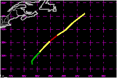
a. Synoptic HistoryHarvey formed from a tropical wave that passed to the south
of the Cape Verde Islands on 12 September. A cloud system center was identified
in satellite imagery on this day and Dvorak classifications were made
intermittently over the next several days. Animation of satellite imagery
indicated that the disturbance gradually became a little better organized
as it interacted with an upper-level low on the18th. The "best track"
indicates that a tropical depression formed about 350 nautical miles south-southeast
if Bermuda at 1800 UTC on 18 September based on a report of 43 mph from
a ship with call letters ELFS that was received at this time. The
ship was located in a band of heavy convection which likely caused the
wind speed in that area to be somewhat higher than was representative
of the depression's interior circulation, centered about 130 nautical
miles to the southwest of the ship. This interpretation is consistent
with Dvorak classifications which were T1.5 or lower at this time. The
depression was moving generally to the north-northwest at 6 to 12 mph,
but gradually turned more toward the northeast and accelerated in response
to an eastward moving short-wave trough approaching from the northwest. b. Meteorological StatisticsThe strongest surface wind of 58 mph was reported by the
American Falcon at 0600 UTC on 21 September while located about 140 nautical
miles east-southeast of the center of Harvey. c. Casualty and Damage StatisticsThere were no deaths or damages reported to the National Hurricane Center related to Harvey.
Maximum
Intensity For Hurricane Harvey
| ||||||||||||||