1993 PRELIMINARY
REPORTS
Tropical
Storm Arlene (TS)
Tropical Storm Bret (TS)
Tropical Storm Cindy (TS)
Tropical Storm Dennis (TS)
Hurricane Emily (3)
Hurricane Floyd (1)
Hurricane Gert (2)
Hurricane Harvey (1)
|
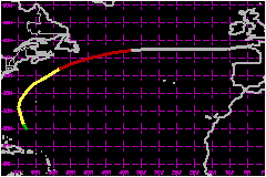
a. Synoptic History
Floyd formed from a tropical wave that crossed the west coast
of Africa on 28 August accompanied by relatively large height falls at
low levels of the atmosphere. Inland surface reports in the vicinity of
Dakar, and observations from several ships, indicate that the wave also
contained a well-defined low-level cyclonic circulation surrounding a
low level pressure center of about 1009 mb on the 28th and 29th.
Satellite pictures indicate that the low moved steadily westward for about
a week with deep convection periodically developing in its vicinity. Initial
Dvorak technique satellite classifications began on the 29th, but by late
on the 31st the system became "too weak to classify" when thunderstorm
activity nearly ceased. Deep convection redeveloped on 3 September about
500 nautical miles to the east of the Leeward Islands, but significant
strengthening was limited by a southwesterly vertical wind shear.
The area of disturbed weather then gradually began to move northwestward
and become better organized. On the 6th, a reconnaissance flight by a
unit of the U.S. Air Force Reserve detected a broad area of surface pressures
near 1011 mb centered within a weak low-level circulation about 150 nautical
miles north of the Virgin Islands. On the following day, a reconnaissance
mission detected a 1008 mb low within a small, low-level circulation associated
with persistent thunderstorm activity. Flight-level winds of 67 mph were
measured at an altitude of 1500 feet that afternoon. The aircraft data
is the basis for indicating in the "best track" that the system
became a tropical depression during the morning of the 7th and strengthened
to become Tropical Storm Floyd during the afternoon.
Floyd quickly became embedded in the fast air currents between a strong
large-scale trough approaching the tropical cyclone from the northwest
and a subtropical high to the east. The steering flow accelerated Floyd
northward to 23 mph, and the storm's center passed about 200 nautical
miles to the west of Bermuda on 8 September. Strong southwesterly wind
shear kept the system from strengthening and, in fact, the last reconnaissance
flight in Floyd indicated that the central pressure had risen to 1012
mb by mid day on the 8th. The system still appeared sheared on the day's
final visible satellite pictures, with a low-level cloud center appearing
poorly-organized on the southwestern edge of the main area of convective
clouds.
Floyd's structure changed considerably over night and the storm intensified.
By morning, the low-level circulation center was no longer exposed, but
estimated to be near the center of the convective overcast. The storm
was racing northeastward at about 40 mph near the eastern end of the ribbon
of warm Gulf Stream waters. Beginning near 1500 UTC, satellite imagery
occasionally showed a recessed spot within the deep clouds near the estimated
circulation center that could be interpreted as a partially formed eye.
At 2000 UTC, the circulation center of Floyd passed about 40 nautical
miles to the northwest of Canadian Buoy 44141. The buoy reported
a pressure of 998 mb, a sea-surface temperature of 27.1°C, and a peak
2-minute wind of 69 mph during the hour ending at 2000 UTC. It is quike
likely that a 1-minute wind speed of at least 74 mph occurred elsewhere
within the southern part of the surface circulation, probably a little
closer to the circulation center. Based on this analysis and the hint
of an eye on satellite pictures, Floyd is estimated to have become a hurricane
with 75 mph maximum 1-minute surface wind speed at 1800 UTC on the 9th.
Floyd's forward speed continued to increase late on the 9th and early
on the 10th. The hurricane was moving at nearly 52 mph when it began to
lose its tropical characteristics over 19°C water. Deep convection
diminished on the 10th, and as the day progressed, it became displaced
further to the northeast of the estimated low-level circulation center.
Ship reports indicated an expanded wind field to the south. The system
is estimated to have become an extratropical storm with 75 mph winds at
1800 UTC on the 10th.
Surface data indicate that the extratropical storm decelerated on an eastward
heading over the following two days. The system began another deepening
phase on the 11th and its center swept inland on the Brittany coast of
France early on the 13th with a pressure of about 966 mb and estimated
maximum sustained surface winds near 81 mph.
b. Meteorological Statistics
The hurricane is estimated to have maintained maximum sustained
winds of 75 mph and a minimum pressure of 990 mb until becoming extratropical.
c. Casualty and Damage Statistics
No reports of damage or casualties related to Floyd have
been received by the NHC.
Maximum
Intensity For Hurricane Floyd
07 - 13 September, 1993
Date/Time
(UTC) |
Position |
Pressure
(mb) |
Wind Speed
(mph) |
Stage |
| Lat. (°N) |
Lon. (°W) |
| 12/1800 |
48.0 |
6.0 |
966 |
80 |
Extratropical Storm |
|