|
|
|
|
|||||||||||||||||||||||||||||||||||||||||||||
|---|---|---|---|---|---|---|---|---|---|---|---|---|---|---|---|---|---|---|---|---|---|---|---|---|---|---|---|---|---|---|---|---|---|---|---|---|---|---|---|---|---|---|---|---|---|
|
1992 PRELIMINARY
REPORTS |
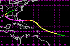
Andrew was a small and ferocious Cape Verde hurricane that wrought unprecedented economic devastation along a path through the northwestern Bahamas, the southern Florida peninsula, and south-central Louisiana. Damage in the United States is estimated to be near $26.5 Billion, making Andrew the most expensive natural disaster in U.S. history. The tropical cyclone struck southern Dade County, Florida, especially hard, with violent winds and storm surges characteristic of a category 4 hurricane on the Saffir/Simpson Hurricane Scale, and with a central pressure (922 mb) that is the third lowest this century for a hurricane at landfall in the United States. In Dade County alone, the forces of Andrew resulted in 15 deaths and up to one-quarter million people left temporarily homeless. An additional 25 lives were lost in Dade County from the indirect effects of Andrew. The direct loss of life seems remarkably low considering the destruction caused by this hurricane. a. Synoptic HistorySatellite pictures and upper-air data indicate that Hurricane
Andrew formed from a tropical wave that crossed from the west coast of
Africa to the tropical North Atlantic Ocean on 14 August 1992. The wave
moved westward at about 23 mph, steered by a swift and deep easterly current
on the south side of an area of high pressure. The wave passed to the
south of the Cape Verde Islands on the following day. At that point, meteorologists
at the National Hurricane Center (NHC) Tropical Satellite Analysis and
Forecast (TSAF) unit and the Synoptic Analysis Branch (SAB) of the National
Environmental Satellite Data and Information Service (NESDIS) found the
wave sufficiently well-organized to begin classifying the intensity of
the system using the Dvorak (1984) analysis technique. Convection subsequently became more focused in a region of
cyclonic cloud rotation. Narrow spiral-shaped bands of clouds developed
around the center of rotation on 16 August. At 1800 UTC on the 16th (UTC
precedes EDT by four hours), both the TSAF unit and SAB calculated a Dvorak
T-number of 2.0 and the "best track" shows that the transition from tropical
wave to tropical depression took place at that time. The depression was initially embedded in an environment of
easterly vertical wind shear. By midday on the 17th, however, the shear
diminished. The depression grew stronger and, at 1200 UTC 17 August, it
became Andrew, the first Atlantic tropical storm of the 1992 hurricane
season. The tropical cyclone continued moving rapidly on a heading which
turned from west to west-northwest. This course was in the general direction
of the Lesser Antilles. Between the 17th and 20th of August, the tropical storm passed
south of the center of the high pressure area over the eastern Atlantic.
Steering currents carried Andrew closer to a strong upper-level low pressure
system centered about 500 nautical miles to the east-southeast of Bermuda
and to a trough that extended southward from the low for a few hundred
miles. These currents gradually changed and Andrew decelerated on a course
which became northwesterly. This change in heading spared the Lesser Antilles
from an encounter with Andrew. The change in track also brought the tropical
storm into an environment of strong southwesterly vertical wind shear
and quite high surface pressures to its north. Although the estimated
maximum wind speed of Andrew varied little then, a rather remarkable evolution
occurred. Satellite images suggest that Andrew produced deep convection
only sporadically for several days, mainly in several bursts of about
12 hours duration. Also, the deep convection did not persist. Instead,
it was stripped away from the low-level circulation by the strong southwesterly
flow at upper levels. Air Force Reserve unit reconnaissance aircraft investigated
Andrew and, on the 20th, found that the cyclone had degenerated to the
extent that only a diffuse low-level circulation center remained. Andrew's
central pressure rose considerably. Nevertheless, the flight-level data
indicated that Andrew retained a vigorous circulation aloft. Wind speeds
near 81 mph were measured at an altitude of 1500 ft near
a convective band lying to the northeast of the low-level center. Hence,
Andrew is estimated on 20 August to have been a tropical storm with 46
mph surface winds and an astonishingly high central pressure of
1015 mb. Significant changes in the large-scale environment near and
downstream from Andrew began by 21 August. Satellite imagery in the water
vapor channel indicated that the low aloft to the east-southeast of Bermuda
weakened and split. The bulk of the low opened into a trough which retreated
northward. That evolution decreased the vertical wind shear over Andrew.
The remainder of the low dropped southward to a position just southwest
of Andrew where its circulation enhanced the upper-level outflow over
the tropical storm. At the same time, a strong and deep high pressure
cell formed near the U.S. southeast coast. A ridge built eastward from
the high into the southwestern Atlantic with its axis lying just north
of Andrew. The associated steering flow over the tropical storm became
easterly. Andrew turned toward the west, accelerated to near 18 mph, and
quickly intensified. Andrew reached hurricane strength on the morning of 22 August,
thereby becoming the first Atlantic hurricane to form from a tropical
wave in nearly two years. An eye formed that morning and the rate of strengthening
increased. Just 36 hours later, Andrew reached the borderline between
a category 4 and 5 hurricane and was at its peak intensity. From 0000
UTC on the 21st (when Andrew had a barely perceptible low-level center)
to 1800 UTC on the 23rd the central pressure had fallen by 92 mb, down
to 922 mb. A fall of 72 mb occurred during the last 36 hours of that period
and qualifies as rapid deepening (Holliday and Thompson, 1979). The region of high pressure held steady and drove Andrew nearly
due west for two and a half days beginning on the 22nd. Andrew was a category
4 hurricane when its eye passed over northern Eleuthera Island in the
Bahamas late on the 23rd and then over the southern Berry Islands in the
Bahamas early on the 24th. After leaving the Bahamas, Andrew continued
moving westward toward southeast Florida. Andrew weakened when it passed over the western portion of
the Great Bahama Bank and the pressure rose to 941 mb. However, the hurricane
rapidly reintensified during the last few hours preceding landfall when
it moved over the Straits of Florida. During that period, radar, aircraft
and satellite data showed a decreasing eye diameter and strengthening
"eyewall" convection. Aircraft and inland surface data suggest that the
deepening trend continued up to and slightly inland of the coast. For
example, the eye temperature measured by the reconnaissance aircraft was
at least 1-2C warmer at 1010 UTC (an hour after the eye made landfall)
than it was in the last "fix" about 15 nautical miles offshore at 0804
UTC. These measurements suggest that the convection in the eyewall, and
the associated vertical circulation in the eye and eyewall, became more
vigorous as the storm moved onshore. The radar data indicated that the
convection in the northern eyewall became enhanced with some strong convective
elements rotating around the eyewall in a counter-clockwise fashion as
the storm made landfall. Numerical models suggest that some enhancement
of convection can occur at landfall due to increased boundary-layer convergence
in the eyewall region. That situation appeared to have occurred in Andrew.
The enhanced convection in the north eyewall probably resulted in strong
subsidence in the eye on the inside edge of the north eyewall. This likely
contributed to a displacement of the lowest surface pressure to the north
of the geometric center of the "radar eye". It is estimated that the central
pressure was 922 mb at landfall near Homestead AFB, Florida at 0905 UTC
(5:05 A.M. EDT) 24 August. The maximum sustained surface wind speed (1-min average at
10 meters [about 33 ft] elevation) during landfall over Florida is estimated
at 144 mph, with gusts at that elevation to at least
173 mph. The sustained wind speed corresponds to a category 4 hurricane
on the Saffir/Simpson Hurricane Scale. It should be noted that these wind
speeds are what is estimated to have occurred within the (primarily northern)
eyewall in an open environment such as at an airport, at the standard
10-meter height. The wind experienced at other inland sites was subject
to complex interactions of the airflow with trees, buildings, and other
obstacles in its path. These obstructions create a turbulent, frictional
drag that generally reduces the wind speed. However, they can also produce
brief, local accelerations of the wind immediately adjacent to the structures.
Hence, the wind speed experienced at a given location, such as at a house
in the core region of the hurricane, can vary significantly around the
structure, and cannot be specified with certainty. Andrew moved nearly due westward when over land and crossed
the extreme southern portion of the Florida peninsula in about four hours.
Although the hurricane weakened about one category on the Saffir/Simpson
Hurricane Scale during the transit over land, and the pressure rose to
about 950 mb, Andrew was still a major hurricane when its eyewall passed
over the extreme southwestern Florida coast. The first of two cycles of modest intensification commenced
when the eye reached the Gulf of Mexico. Also, the hurricane continued
to move at a relatively fast pace while its track gradually turned toward
the west-northwest. When Andrew reached the north-central Gulf of Mexico, the high
pressure system to its northeast weakened and a strong mid-latitude trough
approached the area from the northwest. Steering currents began to change.
Andrew turned toward the northwest and its forward speed decreased to
about 9 mph. The hurricane struck a sparsely populated section of the
south-central Louisiana coast with category 3 intensity at about 0830
UTC on the 26th. The landfall location is about 20 nautical miles west-southwest
of Morgan City. Andrew weakened rapidly after landfall, to tropical storm strength
in about 10 hours and to depression status 12 hours later. During this
weakening phase, the cyclone moved northward and then accelerated northeastward.
Andrew and its remnants continued to produce heavy rain that locally exceeded
10 inches near its track. By midday on the 28th, Andrew had begun to merge
with a frontal system over the mid-Atlantic states. b. Meteorological StatisticsThe anemometer at Harbour Island, near the northern end of
Eleuthera Island in the Bahamas, measured a wind speed of 138
mph for an unknown period shortly after 2100 UTC on the 23rd. That
wind speed was the maximum that could be registered by the instrument. Neither of the two conventional measures of hurricane intensity,
central barometric pressure and maximum sustained wind speed, were observed
at official surface weather stations in close proximity to Andrew at landfall
in Florida. Homestead Air Force Base and Tamiami Airport discontinued
routine meteorological observations prior to receiving direct hits from
the hurricane. Miami International Airport was the next closest station,
but it was outside of the eyewall by about 5 nautical miles when Andrew's
center passed to the south of that airport. To supplement the official information, requests for data were
made to the public through the local media. Remarkably, more than 100
quantitative observations were received. Many of the reports came from
observers who vigilantly took readings through frightening conditions
including, in several instances, the moment when their instruments and
even their homes were destroyed. Some of the unofficial observations were dismissed as unrealistic.
Others were rendered suspect or eliminated during follow-up inquiries
or analyses. The remainder, however, revealed a physically consistent
and reasonable pattern. Shortly after Andrew's passage, however, reports of minimum
pressures below 930 mb were received from the vicinity of Homestead, Florida.
Several of the barometers displaying the lowest pressures were subsequently
tested in a pressure chamber and calibrated by the Aircraft Operations
Center (AOC) of NOAA. Two key observations came from a Mrs. Hall and Mr.
Martens, sister and brother. They rode out the storm in residences about
one-quarter mile apart. Mrs. Hall's home was built by her father and grandfather
in 1945 to be hurricane-proof. Although some of the windows broke, the
22-inch thick concrete and coral rock walls held steady, allowing her
to observe her barometer in relative safety. The AOC tests indicate that
the minimum pressure at her home was near 921 mb. The barometer at her
brother's home was judged a little more reliable and the reading there
was adjusted to 923 mb. Based on the observations and an eastward extrapolation
of the pressure pattern to the coastline, Andrew's minimum pressure at
landfall is estimated to be 922 mb. This suggests that the trajectory
of the dropsonde deployed from the aircraft did not intersect the lowest
pressure within the eye. In the United States, this century, only the Labor Day (Keys')
Storm in 1935 (892 mb) and Hurricane Camille in 1969 (909 mb) had lower
landfall central pressures than Andrew (Hebert et al. 1992). The strongest reported sustained wind near the surface occurred
at the Fowey Rocks weather station at 0800 UTC. The station sits about
11 nautical miles east of the shoreline and, at that time, was within
the northwest part of Andrew's eyewall. The 0800 UTC data included a two-minute
wind of 141 mph with a gust to 169 mph at a platform
height of about 130 feet. The U.S. National Data Buoy Center used a boundary-layer
model to convert the sustained wind to a two-minute wind of 124
mph at 33 ft elevation. The peak one-minute wind during that two-minute
period at Fowey Rocks might have been slightly higher than 124
mph . It is unlikely that this point observation was so fortuitously
situated that it represents a sampling of the absolute strongest wind.
The Fowey Rocks log (not shown) indicates that the wind speed increased
through 0800 UTC. Unfortunately, Fowey Rocks then ceased transmitting
data, presumably because even stronger winds disabled the instrumentation.
(A subsequent visual inspection indicated that the mast supporting the
anemometer had become bent 90 degrees from vertical.) Radar reflectivity
data suggests that the most intense portion of Andrew's eyewall had not
reached Fowey Rocks by 0800 UTC and that the wind speed could have continued
to increase there for another 15 to 30 minutes. A similar conclusion can
be reached from the pressure analysis which indicates that the pressure
at Fowey Rocks probably fell by about another 20 mb from the 0800 UTC
mark of 968 mb. Reconnaissance aircraft provided wind data at a flight level
of about 10,000 ft. The maximum wind speed along 10 seconds of flight
track (often used by the NHC to represent a one-minute wind speed at flight
level) on the last pass prior to landfall was 186 mph, with a spot wind speed of 196
mph observed. The 186 mph wind occurred
at 0810 UTC in the eyewall region about 10 nautical miles to the north
of the center of the eye. Like the observation from Fowey Rocks, the aircraft
provided a series of "point" observations (i.e., no lateral extent). Somewhat
higher wind speeds probably occurred elsewhere in the northern eyewall,
a little to the left and/or to the right of the flight track. A wind speed
at 10,000 ft is usually reduced to obtain a surface wind estimate. Based
on past operational procedures, the 186 mph flight-level
wind is compatible with maximum sustained surface winds of 144
mph. One of the most important wind speed reports came from Tamiami
Airport, located about 9 nautical miles west of the shoreline. As mentioned
earlier, routine weather observations ended at the airport before the
full force of Andrew's (northern) eyewall winds arrived. However, the
official weather observer there, Mr. Scott Morrison, remained on-station
and continued to watch the wind speed dial. Mr. Morrison notes that around
0845 UTC (0445 EDT) the wind speed indicator "pegged" at a position a
little beyond the dial's highest marking of 115 mph,
at a point that he estimates corresponds to about 127
mph. (Subsequent tests of the wind speed dials observed at the
airport indicate that the needles peg at about 121 mph
and 124 mph, respectively). He recounts that the needle was essentially
fixed at that spot for three to five minutes, and then fell back to 0
when the anemometer failed. Mr. Morrison's observations have been closely
corroborated by two other people. He has also noted that the weather conditions
deteriorated even further after that time and were at their worst about
30 minutes later. This information suggests that, in all likelihood, the
maximum sustained wind speed at Tamiami Airport significantly exceeded
121 mph. The reliability of some of the others suffer from problems
that include non-standard averaging periods and instrument exposures,
and equipment failures prior to the arrival of the strongest winds. The only measurement of a sustained wind in the southern eyewall
came from an anemometer on the mast of an anchored sailboat. For at least
13 minutes the anemometer there showed 114 mph,
which was the maximum that the readout could display. A small downward
adjustment of the speed should probably be applied because the instrument
was sitting 17 m above the surface rather than at the standard height
of 10 m. On the other hand, the highest one-minute wind speed during that
13-minute period could have been quite a bit stronger than 114
mph. Again, there may have been stronger winds elsewhere in the
southern eyewall. For a westward-moving hurricane the wind speed in the
northern eyewall usually exceeds the wind speed in the southern eyewall
by about twice the forward speed of the hurricane (Dunn and Miller 1964).
In the case of Andrew, that difference is about 37 mph, and suggests a
maximum sustained wind stronger than 150 mph. Several indirect measures of the sustained wind speed are of
interest. First, a standard empirical relationship between central pressure
and wind speed (Kraft 1961) applied to 922 mb yields around 155
mph. Second, the Dvorak technique classification performed by the
NHC Tropical Satellite Analysis and Forecast unit using a 0900 UTC satellite
image gives 146 mph. The strongest gust reported from near the surface occurred
in the northern eyewall a little more than a mile from the shoreline at
the home of Mr. Randy Fairbank. He observed a gust of 212 mph moments before portions of a windward wall failed,
preventing further observation. The hurricane also destroyed the anemometer.
To evaluate the accuracy of the instrument, three anemometers of the type
used by Mr. Fairbank were tested in a wind tunnel at Virginia Polytechnic
Institute and State University. Although the turbulent nature of the hurricane
winds could not be replicated, the results of the wind tunnel tests suggest
that the gust Mr. Fairbank observed was less than 212 mph and probably
near 177 mph. Of course, stronger gusts may have
occurred there at a later time, or at another site. Damage at that location
was significantly less than the damage to similar structures located about
2 miles south of this neighborhood, implying even stronger winds than
observed at this location. Strong winds also occurred outside of the eyewall, especially
in association with convective bands. A peak gust to 160
mph was observed at a home near the northern end of Dade County
on an anemometer of the brand used by Mr. Fairbank. Applying the reduction
suggested by the wind tunnel tests to 160 mph
yields an estimate close to the 132 mph peak gust
(a five-second average) registered on a National Ocean Survey anemometer
located not far to the east, at the coast. 1. Storm Surge DataDuring the afternoon of 23 August, Andrew crossed over the
north end of the island of Eleuthera in the Bahamas and generated significant
storm surge flooding. Two high water marks were recorded and referenced
to mean sea level. The first mark of 16 ft was recorded in a house in
the town of Little Bogue. The second mark of 23 ft was recorded in a damaged
house in the town of The Current several miles west of Lower Bogue. Since
this structure was located near the shoreline it suggests that battering
waves riding on top of the storm surge helped to create this very high
water mark. During the morning hour of 24 August, Andrew generated storm
surge along shorelines of southern Florida. On the southeast Florida coast,
peak storm surge arrived near the time of high astronomical tide. The
height of the storm tide (the sum of the storm surge and astronomical
tide, referenced to mean sea level) ranged from 4 to 6 ft in northern
Biscayne bay increasing to a maximum value of 16.9 ft at the Burger King
International Headquarters, located on the western shoreline in the center
of the bay, and decreasing to 4 to 5 ft in southern Biscayne Bay. The
observed storm tide values on the Florida southwest coast ranged from
4 to 5 ft near Flamingo to 6 to 7 ft near Goodland. Storm tides in Louisiana were at least 8 ft and caused flooding from Lake Borgne westward through Vermillion Bay. 2. Rainfall DataAndrew dropped sufficient rain to cause local floods even
though the hurricane was relatively small and generally moved rather fast.
Rainfall totals in excess of seven inches were recorded in southeast Florida,
Louisiana, and Mississippi. Rainfall amounts near five inches occurred
in several neighboring states. Hammond, Louisiana reported the highest
total, 11.92 inches. 3. TornadoesThere have been no confirmed reports of tornadoes associated
with Andrew over the Bahamas or Florida. Funnel sightings, some unconfirmed,
were reported in the Florida counties of Glades, Collier and Highlands,
where Andrew crossed in daylight. In Louisiana, one tornado occurred in
the city of Laplace several hours prior to Andrew's landfall. That tornado
killed 2 people and injured 32 others. Tornadoes in the Ascension, Iberville,
Baton Rouge, Pointe Coupee, and Avoyelles parishes of Louisiana reportedly
did not result in casualties. Numerous reports of funnel clouds were received
by officials in Mississippi and tornadoes were suspected to have caused
damage in several Mississippi counties. In Alabama, the occurrence of
two damaging tornadoes has been confirmed over the mainland while another
tornado may have hit Dauphin Island. As Andrew and its remnants moved
northeastward over the eastern states, it continued to produce severe
weather. For example, several damaging tornadoes in Georgia late on 27
August were attributed to Andrew. c. Casualty and Damage Statistics There were 26 deaths attributed to Andrew; 15 in Florida,
8 in Louisiana and 1 in Bahamas. Damage is estimated at $26.5 Billion.
Andrew's impact on southern Dade County, Florida was extreme from the
Kendall district southward through Homestead and Florida City, to near
Key Largo. Andrew reportedly destroyed 25,524 homes and damaged 101,241
others. The Dade County Grand Jury reported that ninety percent of all
mobile homes in south Dade County were totally destroyed. In Homestead,
more than 99% (1167 of 1176) of all mobile homes were completely destroyed.
The Miami Herald reported $0.5 Billion in
losses to boats in southeast Florida. The most devasted areas correspond closely in location to the
regions overspread by Andrew's eyewall and its accompanying core of destructive
winds and, near the coastline, decimating storm surges. Flight-level data
about an hour prior to landfall places the radius of maximum wind at 11
nautical miles (in the northern eyewall at 10,000 ft altitude). The radius
of maximum wind at the surface was likely a little less than 11 nautical
miles. The damage to Louisiana is estimated at $1
Billion. Damage in the Bahamas has been estimated at $0.25
Billion. Andrew whipped up powerful seas which extensively damaged many
offshore structures, including the artificial reef system of southeast
Florida. For example, the Belzona Barge is a 215 ft, 350-ton barge that,
prior to Andrew, was sitting in 68 ft of water on the ocean floor. One
thousand tons of concrete from the old Card Sound bridge lay on the deck.
The hurricane moved the barge 700 ft to the west (50-100 tons of concrete
remain on deck) and removed several large sections of steel plate sidings. Damage in the Gulf of Mexico is preliminarily estimated at
$0.5 Billion. Ocean Oil reported the following
in the Gulf of Mexico: 13 toppled platforms, five leaning platforms, 21
toppled satellites, 23 leaning satellites, 104 incidents of structural
damage, seven incidents of pollution, two fires, and five drilling wells
blown off location. Hurricanes are notoriously capricious. Andrew was a compact system. A little larger system, or one making landfall just a few nautical miles further to the north, would have been catastrophic for heavily populated, highly commercialized and no less vulnerable areas to the north. That area includes downtown Miami, Miami Beach, Key Biscayne and Fort Lauderdale. Andrew also left the highly vulnerable New Orleans region relatively unscathed.
Maximum Intensity For Hurricane
Andrew
Landfall for Hurricane
Andrew
| ||||||||||||||||||||||||||||||||||||||||||||