1992 PRELIMINARY
REPORTS
Hurricane
Andrew (5)
Hurricane Bonnie (2)
Hurricane Charley (2)
Tropical Storm Danielle (TS)
Tropical Storm Earl (TS)
Hurricane Frances (1)
|
a. Synoptic History
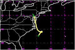
Danielle originated within a weak surface trough and area
of cloudiness and thunderstorms that had persisted over the Atlantic near
the southeast U.S. coast since 18 September. It is also speculated that
a weak tropical wave, which passed from Africa into the Atlantic on 8
or 9 September, moved into this area on the 18th. A cold front merged
with the northern portion of this stationary weather area on the 20th.
By the 22nd, surface reports and satellite imagery showed that a closed
cyclonic circulation formed about 175 nautical miles south-southeast of
Cape Hatteras, North Carolina. The circulation is estimated to have become
a tropical depression at 1200 UTC on the 22nd at this location and the
"best track" begins at this time. An Air Force Reserve Unit
aircraft reconnoiterd the system several hours later and reported 52-mph
floght-level winds and the depression was upgraded to Tropical Storm Danielle.
In response to an approaching trough in the westerlies, Danielle moved
slowly northeastward, but the trough passed and was replaced by a high
pressure to the north of the storm. This resulted in a small clockwise
loop on the 23rd and 24th followed by a westward motion toward the Outer
Banks of North Carolina on the 25th. However, the storm soon turned northward
as a large extratropical low approached the Great Lakes and, in combination
with high pressure anchored to the east of the storm, set up a north-northwestward
steering current. Some strengthening occurred as the storm paralleled
the coast of North Carolina, with sustained winds increasing to 63 mph
and the central pressure falling to 1001 mb.
The center of the storm moved inland on the 25th, over the Delmarva dection
of Maryland. The weakening storm moved across Maryland and Delaware and
over eastern Pennsylvania on the 26th, where it dissipated.
b. Meteorological Statistics
The maximum wind reported by aircraft was 72 mph at an elevation of 1500
feet at 1704 UTC on the 25th, while the minimium central pressure was 1001
mb several hours earlier. Peak satellite intensity estimates were 52 mph
and 1000 mb.
There were several coastal reports of tropical storm force winds. The highest
sustained wind speed was 51 mph at Cape Charles, Virginia. The report of
74 mph from the ship Stonewall Jackson is suspected of being somewhat
too high, although it was near the center of the storm at the time and its
pressure of 1001 mb agrees with the reconnaissance value mentioned above.
Also, offshore data buoys as far north as New York Harbor reported tropical
storm force winds.
The storm was within range of several radars including Hatteras, Patuxent
River NAS, the WSR-88D radar at Stirling and, for a short period, Atlantic
City. These showed an increasingly better presentation of a center and heavier
convection prior to landfall which allows for the possibility that the 74-mph
ship report might not be too far off.
1. Storm Surge Data
The highest storm surge report was 5.4 feet above normal
astronomical tide at Cape Hatteras, North Carolina.
2. Rainfall Data
Storm rainfall totals were near 4 inches over central Virginia
and up to 3 inches along the extreme eastern portions of Virginia, Maryland,
Delaware and New Jersey. Eastern Pennsylvania had up to 2 inches of rain.
c. Casualty and Damage Statistics
There were 1 death attributed to Danielle; 1 in New Jersey.
One death was the result of a sailboat being battered and sunk by high
seas to the east of New Jersey. There was minor flooding and significant
beach erosion along the mid-Atlantic coast. According to press reports,
only minor damage resulted from the storm.
Maximum
Sustained Winds For Tropical Storm Danielle
22 - 26 September, 1992
Date/Time
(UTC) |
Position |
Pressure
(mb) |
Wind Speed
(mph) |
Stage |
| Lat. (°N) |
Lon. (°W) |
| 25/1200 |
35.9 |
75.2 |
1001 |
65 |
Tropical Storm |
Minimum
Pressure For Tropical Storm Danielle
22 - 26 September, 1992
Date/Time
(UTC) |
Pressure
(mb) |
Wind Speed
(mph) |
Stage |
Landfall |
| 25/2200 |
1007 |
65 |
Tropical Storm |
Delmarva Peninsula,
Virginia |
|