1992 PRELIMINARY
REPORTS
Hurricane
Andrew (5)
Hurricane Bonnie (2)
Hurricane Charley (2)
Tropical Storm Danielle (TS)
Tropical Storm Earl (TS)
Hurricane Frances (1)
|
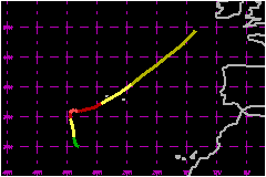
a. Synoptic History
METEOSAT imagery showed that the cloudiness and showers became
concentrated in an area centered about 550 nautical miles south of the
Azores early on 20 September. Animation of the satellite imagery suggested
a mid- to upper-level cyclonic circulation interacting with the northern
portion of a tropical wave. By midday on the 20th, an inverted trough
was analyzed in this vicinity on the NHC surface analysis. Visible imagery
showed a well-defined low-level circulation on 21 September, and satellite
classifications were initiated on this day. The system became Tropical
Depression Five at 1800 UTC on 21 September about 550 nautical miles southwest
of the Azores. The depression began moving toward the northwest at 6 to
12 mph.
Satellite imagery showed increased convective banding on 22 September,
and the system became Tropical Storm Charley at 1200 UTC on this day.
The storm moved generally toward the north for the next couple of days,
steered in part by the flow around the slowly-moving Hurricane
Bonnie located about 1000 nautical miles to the northwest. An eye
appeared in the satellite pictures, and charley became a hurricane at
1200 UTC on 23 September. Analysis of satellite imagery suggests that
the maximum sustained winds were 109 mph and minimum central pressure
was 965 mb near 1800 UTC on 24 September.
Charley began drifted in a general eastward direction by 25 September
in response to the slowly-changing deep-layer-mean flow. On 26 September,
Charley began moving toward the east-northeast with increasing forward
speed over progressively cooler water. Charley was downgraded to a tropical
storm at 0000 UTC on 27 September, while centered just southwest of the
Azores. The storm then accelerated toward the northeast, and the center
passed over the island of Terceira near 1000 UTC on the 27th. Lajes AFB
reported a minimum pressure of 982.4 mb with sustained wind of 53 mph
and gusts to 82 mph.
The storm gradually lost tropical cyclone charactersitics as it moved
over cooler water, and became an extratropical cyclone at 1800 UTC on
the 27th. The acceleration toward the northeast continued, until the system
was absorbed by a larger extratropical low centered to the northwest of
the British Isles near 0600 UTC on 29 September.
b. Meteorological Statistics
Ship FNOM reported winds of 44 mph and a pressure of 983 mb while
very near the center of Charley at 1500 UTC on the 27th.
c. Casualty and Damage Statistics
The NHC has not received reports of casualties or damage
related to Charley.
Maximum
Intensity For Hurricane Charley
21 - 29 September, 1992
Date/Time
(UTC) |
Position |
Pressure
(mb) |
Wind Speed
(mph) |
Stage |
| Lat. (°N) |
Lon. (°W) |
| 24/1800 |
36.1 |
34.1 |
965 |
110 |
Category 2 Hurricane |
|