1992 PRELIMINARY
REPORTS
Hurricane
Andrew (5)
Hurricane Bonnie (2)
Hurricane Charley (2)
Tropical Storm Danielle (TS)
Tropical Storm Earl (TS)
Hurricane Frances (1)
|
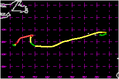
Hurricane Bonnie formed at rather high latitudes
and moved very slowly for a large part of its lifetime. It affected the
Azores with tropical storm conditions, shortly before it became extratropical.
a. Synoptic History
Bonnie had its origins in a non-tropical weather system.
A cold front moved off the east coast of the United States on September
11. The front continued moving southeast and then became stationary, with
its western end in the vicinity of Bermuda by September 15. Surface pressures
fell over an area a few hundred miles east-northeast of Bermuda the following
day, and satellite pictures on the 17th showed that an area of clousiness
and become detached and isolated from the frontal cloud band. The cloud
pattern quickly became organized, exhibiting cyclonically curved bands
and a small circularly-shaped overcast feature. The tropical depression
stage of Bonnie began at 1800 UTC September 17.
The depression strengthened fairly rapidly, and became Tropical Storm
Bonnie around 0600 UTC on the 18th. As is frequently the case in non-tropical-type
developments, Bonnie was initially embedded within a larger-scale deep-layer
cyclonic circulation. This provided an an environment of relatively weak
vertical shear and also controlled the steering of Bonnie during the easrly
stages. Bonnie moved slowly along counterclockwise path before strengthening
into a hurricane at 1800 UTC September 18. The hurricane commenced an
east-northeast to northeast motion on the 19th while exhibiting a fairly
well-defined eye. The eye became indistinct at times on the 20th but on
the 21st, satellite images showed that it had again become rather sharp
in appearance. At 1800 UTC on September 21, Bonnie reached its peak intensity
with estimated maximum winds of 109 mph. The forward motion, which was
also slow, decreased even further on the 22nd. Bonnie was practically
stationary from 1800 UTC on the 22nd until 1200 UTC on the 23rd, when
it began drifting west-southwest. Bonnie weakened considerably as satellite
imagery showed that the low-level center became exposed from the associated
deep convection. Its winds had been reduced to tropical storm strength
on the 24th. By the 25th, Bonnie had lost most of its deep convection
and by 0000 UTC September 26 Bonnie weakened briefly to a tropical depression.
However tropical storm strength was regained a little later on that same
day as deep convection returned.
Bonnie began a southward motion on September 24th which continued until
the 26th at which time Bonnie turned southeast and then east, while picking
up some forward speed. The stalling and southwestward drift of Bonnie
were caused by the northward retreat of deep layer westerlies over the
west-central Atlantic area and the formation of a blocking-type pattern
in the steering currents. A building mid-tropospheric high to the northwest
of Bonnie forced the tropical cyclone southwestward. Subsequently, a broad
deep-layer trough developed over the Atlantic to the east of Bonnie. The
combined effects of the trough and high guided Bonnie southward for a
while. Later on, as the influence of the trough became dominant, Bonnie
was steered southeastward and eastward.
Although Bonnie had restrengthened back to a tropical storm, it remained
in a westerly shearing environment on the 26th and 27th. The circulation
center was generally near the western edge of the deep convective overcast.
However on the 27th, Bonnie's cloud pattern took on a non-tropical comma
shape and the deep convection was confined to an area several degrees
east of the center. By the 28th, convection had returned near the center
and Bonnie looked more like a tropical storm again. The system was then
moving toward the east-northeast and it maintained that course for the
next couple of days with some increase in forward speed. The center of
the storm, moving near 23 mph, passed through the Azores island group
on September 30th. Not much deep convection was associated with the system
and, shortly after passing through the Azores, Bonnie became an extratropical
low. The low then decelerated and looped clockwise, eventually moving
back towards the Azores while dissipating.
b. Meteorological Statistics
The unusually rapid development of a sharply-defined eye in Bonnie on September
19, along with its subsequent (temporary) disappearance on satellite images
on the 20th, are the basis for the first peak in intensity.
A number of ships reported winds of tropical storm force associated with
Bonnie. One ship, with call sign ELE02, reported tropical storm force
winds on four consective days while moving east-northeastward, paralleling
the track of Bonnie.
Lajes Air Base in the Azores had showers and squalls as Bonnie approached.
They reported sustained winds of 40 mph with gusts to 59 mph as Bonnie passed
nearby. Wind gusts to 68 mph were reported atop a 240-foot tower at Lajes.
c. Casualty and Damage Statistics
Apparently, Bonnie did not have serious effects on the Azores.
No reports of casualties or damage due to Bonnie have been received.
Maximum
Intensity For Hurricane Bonnie
17 September - 02 October, 1992
Date/Time
(UTC) |
Position |
Pressure
(mb) |
Wind Speed
(mph) |
Stage |
| Lat. (°N) |
Lon. (°W) |
| 21/1800 |
37.5 |
52.3 |
965 |
110 |
Category 2 Hurricane |
|