1992 PRELIMINARY
REPORTS
Hurricane
Andrew (5)
Hurricane Bonnie (2)
Hurricane Charley (2)
Tropical Storm Danielle (TS)
Tropical Storm Earl (TS)
Hurricane Frances (1)
|
a. Synoptic History
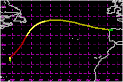
Frances formed about 400 nautical miles to the south-southeast
of Bermuda. Satellite pictures and surface analyses indicate that the
formation occurred within a broad area of low pressure that developed
near the tail end of a weak, quasi-stationary frontal trough. A south-southwesterly
vertical wind shear, associated with a nearly stationary upper-level trough
located over the U.S. east coast and the southwestern Atlantic Ocean,
kept the western portion of the low free of deep convection from the 18th
through the 21st of October. In contrast, the eastern portion of the low
remained under a long, 200 nautical mile wide band of clouds that extended
from north-northwest to south-southeast. Satellite pictures suggest that
the section of the band extending south-southeast from the low was periodically
invigorated for several days by the northern portion of tropical waves.
Water vapor imagery on the 22nd and 23rd showed an upper-level cyclonic
circulation system "cutting-off" to the southwest of the low,
within the upper-level trough. The shear then decreased and with, with
the possible enhancing effects of a tropical wave, the low quickly strengthened
and became a gale center of about 1004 mb by 1800 UTC on the 22nd. The
deep convection then began to wrap cyclonically around the circulation
center and quickly grow in lateral extent. This indicates that the system
was making a transition from a gale center to Tropical Storm Frances.
The transformation was completed shortly after 0600 UTC 23 October.
Several ship reports from the Migaea and Sparrow document
the cyclone strengthened during the transition period. The Migaea
observed a pressure of 1000 mb about 150 nautical miles from the circulation
center at 2230 UTC on the 22nd. By 0200 UTC on 23 October it was closer
to the center and observed 997 mb with sustained winds of 58 mph and gusts
to 85 mph. The Sparrow reported sustained winds of 58 mph near
0000 UTC. Before sunrise, sustained winds approached 75 mph at the Sparrow,
but then dropped temporarily to 39 mph while the wind direction switched
from southeast to northwest. Those changes coincided with the sky partially
clearing and the pressure reaching 996 mb after falling rapidly for several
hours. These observations suggest that the first stages in the formation
of an eye occurred early on the 23rd. It is also noted that the pressures
shown in the "best track" are a little lower than the pressures
discussed above because the observations were not made at the site of
minimum pressure.
Frances continued to strengthen through the 23rd. The ship TSL Bold, located
30-45 nautical miles southeast of the center of Frances, reported a pressure
of 994 mb at 1600 UTC and a southwest wind of 75 mph four hours later.
An eye appeared for the first time on satellite images during that period.
The initial reconnaissance mission in the cyclone found a 979 mb central
pressure at 2238 UTC. From these data it is estimated that Frances reached
hurricane strength near 1800 UTC.
Frances initially drifted northward, in the general direction of Bermuda.
By late on the 23rd, however, the trough to the west of Frances was reinforced
by a new mid-latitude shortwave trough approaching from the eastern United
States. The associated steering flow accelerated Frances northeastward
to about 23 mph on the 24th. Frances reached its peak intensity, with
estimated 86 mph sustained winds and 976 mb central pressure, on that
day.
The track toward the northeast carried Frances over colder water. The
eye became indistinct on the 25th, although relatively deep convection
persisted near the circulation center through early on the 27th. Analyses
of surface weather maps indicate a gradual broadening of the wind field
during that period. Frances became extratropical at about 0600 UTC on
the 27th. Over the following three days, Frances moved generally to the
east as a complex extratropical gale.
b. Meteorological Statistics
There were ship reports of 39 mph or stronger winds.
c. Casualty and Damage Statistics
Sailor Mike Plant was reported missing over the North central
Atlantic during the latter part of October. The U.S. Coast Guard has not,
to date, concluded that Mr. Plant's disappearance is directly related
to Frances.
Ms. Anita Page was the only person aboard the 35 foot sailboat Sparrow.
She suffered a broken rib and the boat was partially disabled during her
encounter with the cyclone on the 22nd and 23rd.
No other reports of damage or casualties related to Frances have been
received by the NHC.
Maximum
Intensity For Hurricane Frances
22 - 30 October, 1992
Date/Time
(UTC) |
Position |
Pressure
(mb) |
Wind Speed
(mph) |
Stage |
| Lat. (°N) |
Lon. (°W) |
| 24/1200 |
30.6 |
58.8 |
976 |
85 |
Category 1 Hurricane |
|