1992 PRELIMINARY
REPORTS
Hurricane
Andrew (5)
Hurricane Bonnie (2)
Hurricane Charley (2)
Tropical Storm Danielle (TS)
Tropical Storm Earl (TS)
Hurricane Frances (1)
|
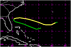
a. Synoptic History
A tropical wave exited the coast of Africa on 18 September
and for several days moved westward through low latitudes accompanied
by disorganized clousiness and showers. Once the wave approached the Lesser
Antilles, it began to interact with a large and strong upper level trough
which was partially related to the outflow from Danielle
and Bonnie located at higher latitudes.
Due to the interaction with the upper trough, most of the convection associated
with the wave shifted further to the north within a band along 62°W
between 22°N and 28°N. The upper trough developed into a cut off
low while moving southwestward toward central Cuba. This new pattern may
have enhanced the upper-level divergence over the convection associated
with the wave, resulting in the formation of a tropical depression about
360 nautical miles north of Hispaniola by 1800 UTC 26 September.
The weak depression moved rapidly on a west-northwest course toward the
northern Bahamas, steered by the flow induced by the middle to upper-level
low over Cuba. However, a cold front, sweeping across the eastern United
States forced the depression to become nearly stationary over the warm
waters of the Gulf Stream where the depression strengthened.
Data from a reconnaissance plane, buoys and ships indicate that the depression
became Tropical Storm Earl at 1200 UTC 29 September. By then Earl was
already moving eastward ahead of the cold front. The tropical storm was
able to maintain its low-level circulation, staying detached from the
frontal zone for several days, reaching its peak intensity of 63 mph and
990 mb at 0000 UTC 2 October.
Earl continued moving on a general east-southeast track, producing transient
convection but maintaining a well-defined low level circulation as indicated
by satellite images. Finally, the storm weakened to a tropical depression
at 1200 UTC 3 October and lost its tropical characteristics later on that
day. The remnants of Earl meandered over the Atlantic for a few more days
until dissipation.
b. Meteorological Statistics
There were ship reports of 39 mph or stronger winds.
c. Casualty and Damage Statistics
There were no reports of casualties or damage associated
with Earl.
Maximum
Intensity For Tropical Storm Earl
26 September - 03 October, 1992
Date/Time
(UTC) |
Position |
Pressure
(mb) |
Wind Speed
(mph) |
Stage |
| Lat. (°N) |
Lon. (°W) |
| 02/0000 |
28.0 |
69.0 |
990 |
65 |
Tropical Storm |
|