1994 PRELIMINARY
REPORTS
Tropical
Storm Alberto (TS)
Tropical Storm Beryl (TS)
Hurricane Chris (1)
Tropical Storm Debby (TS)
Tropical Storm Ernesto (TS)
Hurricane Florence (2)
Hurricane Gordon (1)
|
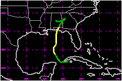
Tropical Storm Alberto caused minor damage and no casualties when it
came ashore in the Florida panhandle. Although the winds then quickly
diminished, the remnants meandered for four days through eastern Alabama
and western Georgia, producing record-breaking rainfall, and floods
that over the course of a week took 28 lives in Georgia and 2 lives
in Alabama. Alberto caused damage estimated at $500
Million.
a. Synoptic History
Alberto's origin is traced to a tropical wave detected in
Dakar, Senegal rawindsonde data on 18 June. Satellite pictures indicate
that the wave then progressed steadily westward for several days accompanied
by a broad area of low clouds and a hint of dust. The wave produced showers
over the Lesser Antilles, but little deep convection occurred until a
cluster of thunderstorms developed over the waters just north of the Virgin
Islands and Puerto Rico early on the 26th. When the cluster neared the
central Bahamas two days later, however, it was sheared apart by westerly
winds aloft associated with a short-wave trough progressing eastward into
the Atlantic.
Beginning on the 28th, water vapor imagery and sounding data showed the
axis of a narrow mid- to upper-level trough or cyclonic shear zone becoming
nearly stationary from south Florida to the nortern Yucutan peninsula.
(This feature developed between the short-wave trough noted above and
a slow-moving east-west oriented trough over the southern Gulf of Mexico.)
Southwesterly winds ahead of the axis were rather light. Hence, when the
tropical wave moved across Cuba and the adjacent waters of Caribbean Sea
on the 29th, it encountered a light vertical wind shear. Deep convection
quickly increased and became concentrated over central Cuba. Rawindsonde
data from Camaguey, Cuba indicated the pressure of a closed low at 850
and 700 mb. A little later, surface data showed the first signs of an
associated surface low in that area.
By midday on the 30th, the disturbed weather crossed the Isle of Youth
and was centered near the Western tip of Cuba. The first reconnaissance
flight into the area, by a NOAA aircraft, indicated a well-defined circulation
at 1000 feet altitude and a central pressure of 1008 mb at 1902 UTC. Based
on those observations, and earlier ship and land reports, it is estimated
that the system became Tropical Depression One with 30 mph surface winds
near 0600 UTC on the 30th. The depression initially moved westward at
about 8 mph.
A low aloft was then forming within the trough just to the west of the
depression. That low moved quickly westward and was located over the south-central
Gulf of Mexico by the 1st of July. In addition, the next mid-latitude
short-wave trough swept eastward across the northern Gulf. This combination
put the depression in a modest, mainly southerly steering flow and shear.
The depression gradually turned more to the north, but remained rather
poorly-organized with a partially exposed low-level center seen on satellite
pictures.
The low aloft shifted farther away from the depression, into the southwestern
Gulf. Reconnaissance aircraft data from the U.S. Air Force Reserves indicates
that the depression strengthened to become Tropical Storm Alberto near
0000 UTC on the 2nd. Later that day, the ship Robert E. Lee reported 51
mph winds about 40 nautical miles to the north of Alberto's center.
A third short-wave trough approached the central Guf states late on the
2nd. The steering flow ahead of the trough axis accelerated Alberto northward,
from 8 to 14 mph, toward the Florida panhandle. Alberto continued to strengthen
with its circulation center becoming more embedded within deep convection.
Alberto was at its peak intensity, 993 mb and 63 mph winds, when the center
made landfall near Dustin, Florida at 1500 UTC on the 3rd. At that time,
visible satellite pictures showed a recessed spot near the middle of the
central cloud feature that may have indicated the first stages in the
development of an eye.
Winds then quickly subsided and Alberto's central pressure rose rapidly.
Alberto weakened back to a tropical depression near 0000 UTC on the 4th.
Alberto's northward progress was then retarded and eventually halted when
it was bypassed by the third short-wave trough and blocked by an area
of high pressure that built that trough, to the north of Alberto.
By 1800 UTC on the 4th, the central pressure increased to 1014 mb and
surface winds speeds decreased to around 23 mph. Surface data indicate
that the cyclonic circulation spun down very slowly after that time. In
addition, satellite pictures and WSR-88D radar data continued to show
a well-defined, cyclonically turning cloud and reflectivity pattern moving
slowly through eastern Alabama and western Georgia until late on 7 July.
The system produced locally torrential rain during that period, inducing
numerous floods that continued many days after the tropical cyclone dissipated.
b. Meteorological Statistics
The highest officially recorded 1-min wind speed at the surface
was 40 mph, observed at Eglin AFB/Valparaiso (VPS) and Hurlburt Field
(HRT). The Coast Guard Station at Destin recorded a gust to 75 mph. VPS
had a peak gust of 68 mph. An unofficial gust to 86 mph at 1405 UTC was
reported from a portable anemometer in an open exposure in Destin. This
comparable to the highest wind speed just above the shoreline shown by
Eglin AFB/Valparaiso (KEVX) WSR-88D radar about 50 minutes later. The
reconnaissance flight at about that time had peak 1500 feett flight-level
winds of about 77 mph.
Alberto's estimated minimum pressure of 993 mb is based on reconnaissance
measurements of that value and an unofficial observation of 994 mb at
Destin.
1. Storm Surge Data
A storm tide of 5 feet was estimated near Destin. A 3 foot
storm surge (NGVD) occurred at Panama City, Panama City Beach, Turkey
Point and Apalachicola.
2. Rainfall Data
The Isle of Youth, Cuba had about 10 inches of rain while
Alberto became organized into a depression. Rainfall totals for the landfall
area in northwest Florida were about 5 inches. Record rains occurred farther
to the north in association with the slowly-weakening depression over
the following several days. The KEVX WSR-88D radar indicated a roughly
50 nautical miles wide swath of greater than 5 inches of rainfall extending
from near Crestview, Florida to west-central Georgia during the 35-hour
period ending near 2000 UTC on the 6th. It also showed a maximum of 14.6
inches for that period.
Americus, Georgia received more than 21 inches of rain in a 24-hour period
ending on the morning of 6 July and 27.61 inches fell there from 4-7 July.
Macon, Georgia established their one-day rainfall record with 10.25 inches.
When the depression headed westward on the 6th, heavy rains returned to
the Florida panhandle and rainfall up to 8 inches was estimated to have
fallen on the night of the 6th-7th near D'Iberville, Mississippi.
Many rivers and creeks in Georgia and in the Florida panhandle flooded.
The Flint River crested above flood stage by about 24 feet in Albany,
Georgia. Some dams were overtopped and broken by the river torrents in
Georgia.
c. Casualty and Damage Statistics
Although 13 people were rescued offshore, no casualties and
mostly minor damage (e.g., limited beach erosion, downed trees and power
lines) are attributed to Alberto through about the first day following
landfall. The most extensive beach erosion (up to 14 feet) was reported
on Cape San Blas.
Subsequent rains resulted in the failure of two hydroelectric dams and
82 small dams. The associated floods, in some instances exceeded 100-year
event thresholds. The floods were directly responsible for the loss of
28 lives in Georgia and 2 in Alabama. Some of the fatalities were reported
as much as a week after Alberto's landfall and days after the last vestiges
of Alberto's circulation and rain disappeared.
The American Insurance Services Group preliminary estimated Alberto's
damage at $500 Million, of which $250-300
Million was insured. A component of the insured loss, damage to
buildings and vehicles, was estimated at $70 Million
in Georgia, $15 Million in Florida and $10
Million in Alabama, and likely to rise further. Crop losses alone
accounted for a $100 Million loss in Georgia.
The total loss in Florida has been estimated at about $80
Million.
About 20,000 people evacuated from Albany, Georgia, 2,000 people left
Bainbridge, Georgia, and about 4,000 people were evacuated from the Florida
panhandle because of the threat of fresh-water flooding. Evacuations also
occurred in parts of Alabama.
A total of 55 counties in Georgia, 13 in Florida, and 10 in Alabama were
declared disaster areas.
Maximum Intensity For Tropical Storm Alberto
30 June - 07 July, 1994
Date/Time
(UTC) |
Position |
Pressure
(mb) |
Wind Speed
(mph) |
Stage |
| Lat. (°N) |
Lon. (°W) |
| 03/1200 |
29.9 |
86.7 |
993 |
65 |
Tropical Storm |
Landfall for Tropical
Storm Alberto
30 June - 07 July, 1994
Date/Time
(UTC) |
Pressure
(mb) |
Wind Speed
(mph) |
Stage |
Landfall |
| 03/1500 |
993 |
65 |
Tropical Storm |
Destin,
Florida |
|