|
|
|
|
|||||||||||||||
|---|---|---|---|---|---|---|---|---|---|---|---|---|---|---|---|
|
1994 PRELIMINARY
REPORTS |
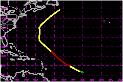
a. Synoptic HistoryChris originated from as a tropical wave that moved across
the African coast and into the eastern tropical Atlantic on 11 August.
Moving westward, the wave acquired significant convection and signs of
rotation on the 15th and became a depression on the 16th, midway between
Africa and the Lesser Antilles. The depression strengthened to a tropical storm by the 15th
and to a hurricane on the 18th, while moving toward the northwest at 12
to 17 mph. This strengthening occurred even though there was evidence
of vertical shearing from an upper-level low located to the northwest.
Chris remained a hurricane for almost two days before the strong vertcal
wind shear significantly disrupted the circular symmetry of the cloud
pattern and caused weakening. b. Meteorological StatisticsThe maximum flight level winds mreasured by reconnaissance
aircraft was 70 mph at 700 millibars midday on the 20th. This was the
first aircraft into Chris and, based on satellite intensity estimates,
weakening had already begun. The central sea-level pressure by then was
up to 1009 millibars. Dvorak estimates give a minimum pressure of 979
millibars and a maximum 1-minute surface wind speed of 81 mph on the 19th.
c. Casualty and Damage StatisticsThere were no casualties or damage from Chris. However, Bermuda received 2.83 inches of rainfall from the passage of Chris.
Maximum
Intensity For Hurricane Chris
| ||||||||||||||