1994 PRELIMINARY
REPORTS
Tropical
Storm Alberto (TS)
Tropical Storm Beryl (TS)
Hurricane Chris (1)
Tropical Storm Debby (TS)
Tropical Storm Ernesto (TS)
Hurricane Florence (2)
Hurricane Gordon (1)
|
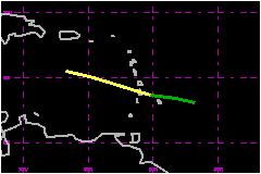
Tropical Storm Debby lasted only two days, but locally heavy rain and
gusty winds from the cyclone and its remnants led to the deaths of nine
people near its track across the eastern Caribbean Sea and adjacent
islands.
a. Synoptic History
Debby formed from a westward-moving tropical wave that entered
the eastern tropical Atlantic on the 4th of September. Satellite pictures
showed the system to be quite large on the 6th and, a day later, indicated
several clusters of strong convection with cloud-top temperatures lower
than -80°C. The wave was then located about midway between Africa
and the Lesser Antilles islands.
The amount and intensity of deep convection decreased the
next day as the system encountered a northwesterly vertical wind shear.
The shearing became more westerly and weakened enough for an area of concentrated
convection to redevelop when the wave axis was a few hundred miles east
of the Lesser Antilles late on the 8th.
At 1200 UTC on the 9th, a ship located about 125 nautical miles southeast
of Barbados reported a light north wind just ahead of the system. About
12 hours later, surface observations and satellite pictures suggested
that a surface circulation center was located just west or northwest of
Barbados. NOAA was then conducting the first reconnaissance flight into
this system. At a flight level of 1500 feet, 58-69 mph winds were measured
in a 20-30 nautical mile band that was centered in the vicinity of thunderstorms
about 40 nautical miles north through east of the center. They also estimated
surface winds of 58 mph. A few hours later, this part of the system passed
over Martinique. Surface observations from Martinique and a nearby ship
indicate that, despite the disorganized appearance on satellite pictures,
the system was then a tropical storm with 1-minute wind speeds of about
69 mph. It is estimated that about 18 hours earlier (at about 1200 UTC
on the 9th) the system had become a tropical depression with strong circulation
aloft. In the vicinity of Martinique, the winds were efficiently conveyed
to the surface of thunderstorms.
The tropical cyclone moved toward the west-northwest at about 20 mph.
Westerly vertical wind shear affected the growth of the cyclone by limiting
the amount and intensity of thunderstorms and by displacing most of that
activity 50-150 nautical miles to the east of the low-level circulation
center. The flight level and estimated surface wind speeds reported by
the Air Force Reserve Hurricane Hunter's near 1200 UTC on the 10th were
not as strong as noted earlier, but, just six hours later, returned to
magnitudes that were comparable to those found on the NOAA flight. Meanwhile,
the winds at Martinique only slowly abated as the storm receded. Hence,
while some fluctuation in surface wind speed likely occurred in association
with the variations of deep convection, its is estimated that the surface
wind speeds in Debby remained around 58-69 mph through the 10th.
Even though the system continued to produce locally strong winds on the
11th, its circulation became more disrupted by the strong wind shear.
By 0200 UTC, a closed circulation center could not be identified by the
crew aboard the reconnaissance aircraft. The cyclone is analyzed as degenerating
back to the vigorous tropical wave around the 0600 UTC 11 September synoptic
hour.
The wave continued to produce locally heavy rain and gusty winds that
spread across Hispaniola on the 11th. These conditions advanced westward
before diminishing over the northwest Caribbean Sea and adjacent portions
of Mexico on the 15th. Satellite pictures indicate that some of the activity
could also have spread into the southeastern Gulf of Mexico.
b. Meteorological Statistics
The 69 mph maximum 1-minute surface wind speed at 0600 UTC
is primarily based on hourly reports around that time from two observation
sites in Martinique. At Le Vauclin, on the southeast coast, 10-minute
winds of 64 mph with a gust to 98 mph were recorded. At the Morne des
Cadets observatory, the maximum 10-minute wind was 62 mph with a gust
to 97 mph (The maximum 1-minute wind speed is usually a little higher
than the associated 10-minute average). The nearby ship PJRB (name
unknown) reported a sustained wind of 51 mph at 0600 UTC, and this likely
does not represent the storm's maximum wind at that time.
In addition, the meteorological service of the Dominican Republic reported
gusts to 62 mph on the 11th, but this could have come after Debby ceased
to exist as a tropical cyclone.
The ship PJRB reported 1000.7 mb at 0600 UTC on the 10th. This
pressure is believed to be incorrect. A pressure of 1007.0 mb would have
been more appropiate for that time at their location.
1. Rainfall Data
An isohyet analysis by the meteorological service of Martinique indicates
that about one-half of that island had at least 4 inches of rain. The largest
total was 7.24 inches at Saint Joseph/Rabuchon.
c. Casualty and Damage Statistics
There were 4 deaths attributed to Debby; 4 in St. Lucia.
A total of four people were killed (in two landslides) and 24 injured
in St. Lucia. There was one drowning in Martinique and another (a fisherman)
off the southwest coast of Puerto Rico. Three deaths (apparently related
to downed power lines) were reported in the Dominican Republic. Three
deaths in the Dominican Republic occurred on the 11th, possibly after
Debby had reverted back to a tropical wave.
The associated press indicated that the worst damage occurred in St. Lucia,
where rains caused landslides that blocked main roads, and covered the
town of Pont St. Jacques. Two inches of silt covered the runways at the
main international airport. The rains caused floods that washed away hillside
shacks, eight bridges and portions of some roadways. Water was chest-high
in the village of Anse La Raye. Debby's winds damaged banana plantations
in St. Lucia.
In Martinique, some towns were flooded while wind-felled trees blocked
some roads. The banana crop was also damaged in Martinique. About 20,000
residents lost power and schools were closed.
The meteorological service of the Dominican Republic reported that some
rivers flooded.
The number of people left homeless in the area affected by Debby was estimated
to be in the hundreds.
Maximum Intensity
For Tropical Storm Debby
09 - 11 September, 1994
Date/Time
(UTC) |
Position |
Pressure
(mb) |
Wind Speed
(mph) |
Stage |
| Lat. (°N) |
Lon. (°W) |
| 10/0600 |
14.1 |
61.6 |
1006 |
70 |
Tropical Storm |
Landfall for
Tropical Storm Debby
09 - 11 September, 1994
Date/Time
(UTC) |
Pressure
(mb) |
Wind Speed
(mph) |
Stage |
Landfall |
| 10/0300 |
1007 |
65 |
Tropical Storm |
St. Lucia |
|