1994 PRELIMINARY
REPORTS
Tropical
Storm Alberto (TS)
Tropical Storm Beryl (TS)
Hurricane Chris (1)
Tropical Storm Debby (TS)
Tropical Storm Ernesto (TS)
Hurricane Florence (2)
Hurricane Gordon (1)
|
a. Synoptic History
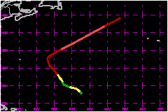
Hurricane Florence developed from a low-pressure system that
formed at the end of October along a stationary frontal band about 1000
nautical miles to the east-southeast of Bermuda. The low gradually acquired
a closed circulation when the portion of the front in its vicinity dissolved
during the first day or two of November.
A curved band of deep convection developed to the north through northeast
of the low on the 2nd of November. Ship reports indicate that the system's
strongest surface winds were then associated with a distant portion of
the convective band, about 200 nautical miles to the northeast of the
center. These features are characteristic of a subtropical cyclone, as
indicated in early satellite "Classifications" of this system
by the NHC Tropical Satellite Analysis and Forcast (TSAF) unit and NESDIS
Synoptic Analysis Branch (SAB). It is estimated that the cyclone became
a subtropical depression at 0000 UTC on the 2nd of November. Ship reports
of 40 mph winds in the convective band support designating the system
a subtropical storm for part of the day on the 2nd and 3rd.
The distant area of convection weakened on the 3rd and ship reports suggest
that maximum wind speeds decreased to about 35 mph. However, deep convection
then became concentrated near the circulation center and the system made
a transition from subtropical to tropical. Dvorak technique estimates
from the TSAF unit and SAB reached T2.5 at 0000 UTC on the 4th and it
is estimated that the cyclone became Tropical Storm Florence at that time.
Florence moved toward the northwest at about 9 mph before turning toward
the north at a decreased speed on the 6th. Although upper-level outflow
was restricted to the south, the cyclone strengthened early in this period.
Satellite pictures revealed a partially developed eye for the first time
around 1700 UTC on the 4th and the system reached hurricane strength about
that time. The eye was occasionally noted but analyses of satellite pictures
implied no significant change in strength over the following three days.
The only reconnaissance mission in Florence, near 1800 UTC on the 6th,
encountered 83 mph maximum winds at a flight level of about 10,000 feet,
and a central pressure of 982 mb.
The hurricane was located about 700 nautical miles to the east of Bermuda
when it reached the westernmost point of its track near 0600 UTC on the
7th. The hurricane had become nearly stationary at that point. It then
turned toward the northeast and accelerated in response to a large and
powerful mid-latitude storm that approached Florence from the Canadian
maritime provinces. Only 24-30 hours later, the associated steering currents
were moving Florence toward the northeast at nearly 52 mph.
A distinct eye surrounded by moderately deep convection was seen on satellite
pictures on the 7th and the hurricane is estimated to have reached its
peak intensity of 109 mph and 972 mb central pressure at 0000 UTC on the
8th. Florence was then within a narrowing sector of warm air between the
large storm to its northwest and another to the northeast. The eye diameter
widened from about 20 to 30-35 nautical miles. The eye remained apparent
until about 1800 UTC, when Florence began moving over water temperatures
below 20°C, and was overtaken and absorbed by the rapidly-moving cold
front previously located to its northwest.
b. Meteorological Statistics
The maximum intensity inferred from application of Dvorak
technique to satellite imagery was about 86-104 mph for Florence. However,
this technique (unlike the Hebert-Poteat method for subtropical systems)
does not include an adjustment to the wind speed that accounts for the
translational speed of exceptionally fast moving cyclones. The estimated
best track maximum intensity of 109 mph for Florence on the 8th incorporates
an attempt to make a reasonable adjustment for that characteristic. There
were no surface obervations to corfirm or reject this estimate.
c. Casualty and Damage Statistics
Florence did not directly affect land and the NHC received
no reports of damages or casualties.
Maximum
Intensity For Hurricane Florence
02 - 08 November, 1994
Date/Time
(UTC) |
Position |
Pressure
(mb) |
Wind Speed
(mph) |
Stage |
| Lat. (°N) |
Lon. (°W) |
| 08/0000 |
37.0 |
49.9 |
972 |
110 |
Category 2 Hurricane |
|