|
|
|
|
||||||||||||||||||||||||||||||||||||||||||||||||||
|---|---|---|---|---|---|---|---|---|---|---|---|---|---|---|---|---|---|---|---|---|---|---|---|---|---|---|---|---|---|---|---|---|---|---|---|---|---|---|---|---|---|---|---|---|---|---|---|---|---|---|
|
1994 PRELIMINARY
REPORTS |
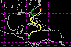
Gordon, a complex system, followed an unusual, erratic path over the western Caribbean Sea and islands, Florida and the southwestern Atlantic. Its torrential rains caused a catastrophic loss of life in Haiti and extensive agricultural damage in south Florida. a. Synoptic HistoryDisturbed weather was noted over the southwestern Caribbean
Sea during much of the first week of November. Convection over the area
was enhanced by the passage of two tropical waves during this period.
The second of these waves induced the formation of a lower-tropospheric
cyclonic circulation, as indicated by rawinsonde data, just to the north
of Panama around 0000 UTC 6 November. Meteorologists at the NHC's Tropical
Satellite Analysis and Forecast (TSAF) unit began tracking this circulation
center from satellite imagery beginning on 6 November. By 1200 UTC 7 November,
the convective cloud pattern associated with this circulation had enough
curvature to warrant an initial satellite intensity classification, a
T1.0 on the Dvorak scale. Early on the 8th, deep convection became concentrated
in a cluster not far offshore of the southeast coast of Nicaragua. By
1800 UTC on the 8th, Dvorak intensity estimates from TSAF and the NESDIS
Synoptic Analysis Branch (SAB) were T2.0 and T1.5 respectively, and surface
observations showed the presence of a 29-mph circulation. The tropical
depression stage of Gordon begins at this time. There was limited upper-level outflow from the system, primarily
to the north and northeast, which favored very slow strengthening. The
depression moved toward the coast of Nicaragua, and an Air Force Hurricane
Hunter plane investigating the system found that the center was very near
the coast by 1800 on the 9th. Spot wind reports from the aircraft suggested
that the cyclone was nearing storm strength. However, the close proximity
to land inhibited further intensification. The center hugged the coast
of Nicaragua from 0000 to 1200 UTC on the 10th, and is estimated to have
moved just onshore near Puerto Cabezas at 0600 UTC. Then, in response
to a trough aloft to the northwest, the tropical cyclone turned northeast,
moving back over the western Caribbean, and strengthened into Tropical
Storm Gordon by 1800 UTC. Data from Air Force flights into Gordon showed
that little additional intensification occurred over the ensuing 24 hours,
as the storm moved slowly north-northeastward. Surface and aircraft data
showed that Gordon consisted of a broad cyclonic circulation, which covered
much of the western Caribbean, within which was embedded a smaller scale
vortex. Visible satellite pictures on the 11th revealed that Gordon
was being sheared by upper level west-southwesterly flow. On 12 November,
Gordon turned east-northeastward, and eastward, heading for Jamaica. Although
bursts of strong convection were occurring near and east of the estimated
storm center, the system remained disorganized with maximum sustained
winds near 46 mph. The low-level center of Gordon
was clearly exposed on visible satellite pictures on the 12th. Gordon's
center moved across eastern Jamaica early on the 13th and accelerated
further, nearing eastern Cuba by 1200 UTC that same day. As Gordon passed
near Guantanamo, Cuba, the center became disorganized and difficult to
locate. However, it is estimated from surface synoptic reports that the
center that was previously being tracked moved rapidly northward across
Cuba and was nearing the southern Bahamas by 1800 UTC 13 November. Around
that time, Gordon's structure started to become more complicated. While Gordon was crossing Cuba, an upper-tropospheric trough,
which had been intensifying along 80�W north of 20�N, was cutting off
a cyclonic circulation near the Straits of Florida. This upper-level system
appeared to induce surface cyclogenesis in the vicinity of the central
Bahamas. From 1800 UTC on the 13th through 0000 UTC on the 14th, there
were multiple low-level centers embedded within a broader-scale circulation
that covered most of central-eastern Cuba and the Bahamas. This larger
circulation had accompanied Gordon since the tropical cyclone's inception,
but was strengthened and modified by the influence of the upper-level
cyclone. After 0000 UTC on the 14th, the cloud pattern and surface wind
field resembled that of a subtropical cyclone, with a center of circulation
becoming dominant just to the south of the central Bahamas. A deep-layer ridge near the U.S. mid-Atlantic coast and a larger-scale
deep-layer cyclone (within which Gordon was embedded) provided a steering
current which carried Gordon, in its transformed state, west-northwestward.
As a result of the increased surface pressure gradient between the broad
low that accompanied Gordon and the high to the north, winds increased
to near gale force over portions of the Florida peninsula late on the
13th. The center of Gordon passed south of the western Bahamas on the
14th and moved across the Straits of Florida early on the 15th. During
this time, there was a lack of deep convection near the center and strongest
winds were well-removed from the center. Radiosonde data were indicative
of a cold-core system, except over the eastern portion of the circulation
where warmer mid-tropospheric air was still prevalent. As Gordon moved over the Straits of Florida, Air Force Hurricane
Hunters estimated that the center was rather close to the coast of Cuba,
since they were unable to close off a circulation to the north of the
"no-fly" line off the north coast of the island. However, the center was
broad at this time with light winds covering much of the southern Straits.
Just before dawn on the 15th, the radar observations from Key West suggested
a reformation of Gordon's center just to the south of the lower Florida
Keys, closer to deep convection. A special radiosonde release from Key
West at 0600 UTC showed mid-tropospheric warming near the center of cyclone,
indicating that Gordon was beginning to re-acquire tropical characteristics.
The broad center moved northwestward over the lower Keys, and decelerated
over the extreme southeast Gulf of Mexico. Early on the 16th, Gordon turned
northward, and then north-northeastward, recurving under the influence
of a mid- to upper-tropospheric shortwave trough moving eastward from
the central United States. By 1300 UTC that day, the center crossed the
southwest coast of Florida near Fort Myers. Maximum sustained winds were
near 52 mph. Moving northeastward, Gordon crossed the Florida peninsula,
its center emerging over the Atlantic just north of Vero Beach around
2200 UTC 16 November. Central pressure was falling, and based on a report
from the ship ZHEM7, maximum winds increased to near 63 mph shortly after Gordon moved back over the water.
Gordon's northeastward motion accelerated on the 17th, and it strengthened
into a hurricane. Just when it appeared to be headed safely out to sea,
however, the hurricane abruptly slowed down and turned northward, then
northwestward, and then west-northwestward, threatening the coast of North
Carolina. This turn of events could be attributed to a mid-tropospheric
ridge, which built over the eastern U.S. behind the shortwave trough that
brought about Gordon's latest recurvature, and the fact that the trough
essentially "out-ran" Gordon. The center of the hurricane came within
about 80 nautical miles of the Outer Banks at 1200 UTC 18 November, before
turning southward and south-southeastward. Gordon weakened to a tropical
storm around 1800 UTC on the 18th as it entrained cooler, drier air into
its circulation and was affected by northwesterly shear. Turning southward
and then southwestward, weakening Gordon executed a track off the southeast
U.S. coast. Gordon lost most of its deep convection on the 19th, and weakened
to a depression early on the 20th. The weakening depression turned westward
and west-northwestward, crossing the coast of Florida near Cape Canaveral
as an inconsequential tropical cyclone. Gordon turned northward, then
north-northeastward, crossed Georgia, and dissipated over South Carolina.
b. Meteorological StatisticsA number of observing sites reported sustained winds of tropical
storm force. Some regional maxima are of interest. In Florida, the highest
known sustained wind speed measurement from a land station, 53
mph, was from Virginia Key. A peak gust of 83
mph was recorded by an amateur meteorologist in southern Dade County.
A 10-minute average wind speed of 71 mph was obtained
from Diamond Shoals lighthouse, off the North Carolina Outer Banks. The
69-mph 1-minute winds with peak gusts to 120
mph, reported from the Guantanamo Navy base, occurred in a thunderstorm
microburst and is not considered representative of the intensity of the
tropical storm when it was near that site. There were a number of ship reports of tropical storm force
winds associated with Gordon. Ships WPPO and KLHC reported
the highest sustained winds, 78 mph, and ship
LAHE2 reported the lowest pressure, 987 mb. The Air Force Reserve's Hurricane Hunter unit carried out numerous
missions into Gordon, providing valuable information on its position,
intensity and wind distribution. Gordon's peak intensity is estimated
to have occurred around 0000 UTC 18 November, when reconnaissance data
from the Hurricane Hunters indicated a minimum pressure of 980 mb. Peak
flight-level (700 mb) winds of 110 mph were measured
at 0123 UTC. This suggests maximum 1-minute surface winds near 86
mph. 1. Rainfall DataGordon produced heavy rains over Jamaica, eastern Cuba and Hispaniola. In Hispaniola the persistent southerly flow to the east of the broad circulation that accompanied Gordon, combined with upslope motion over steep topography, generated prolonged rains that led to disastrous floods and mud slides. Gordon also dumped heavy rains over the Florida peninsula, except for the west coastal area north of Fort Myers. Storm total rainfall amounts of 6 to 9 inches occurred over most of the eastern third of the peninsula, with totals to almost 11 inches in Volusia county, 12 or 13 inches over portions of southern and northern Dade county and as high as 15 or 16 inches in some locations in Broward county.
| |||||||||||||||||||||||||||||||||||||||||||||||||
| Date/Time (UTC) |
Position | Pressure (mb) |
Wind Speed (mph) |
Stage | |
|---|---|---|---|---|---|
| Lat. (°N) | Lon. (°W) | ||||
| 18/0000 | 33.1 | 74.2 | 980 | 85 | Category 1 Hurricane |
Landfall for
Hurricane Gordon
08 - 21 November, 1994
| Date/Time (UTC) |
Pressure (mb) |
Wind Speed (mph) |
Stage | Landfall |
|---|---|---|---|---|
| 10/0600 | 1008 | 35 | Tropical Depression | Puerto Cabezas, Nicaragua |
| 13/0300 | 1000 | 40 | Tropical Storm | Kingston, Jamaica |
| 13/1300 | 1000 | 45 | Tropical Storm | Guatanamo, Cuba |
| 15/1300 | 999 | 50 | Tropical Storm | Key West, Florida |
| 16/1300 | 996 | 50 | Tropical Storm | Fort Myers, Florida |
| 21/0300 | 1011 | 30 | Tropical Depression | Cape Canaveral, Florida |