1994 PRELIMINARY
REPORTS
Tropical
Storm Alberto (TS)
Tropical Storm Beryl (TS)
Hurricane Chris (1)
Tropical Storm Debby (TS)
Tropical Storm Ernesto (TS)
Hurricane Florence (2)
Hurricane Gordon (1)
|
a. Synoptic History
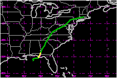
A large upper-level low developed over the southwest North
Atlantic and was centered a few hundred miles north of Puerto Rico on
9 August. It moved westward, and gradually became pronounced in the low-
to mid-levels of the troposphere. Although the low at upper-levels had
weakened to a trough by the time it passed over south Florida on 12 August,
there was evidence of a low- to mid-level cyclonic circulation off the
southwest Florida coast by 1200 UTC on this day. Based on surface observations
from Cuba and ship reports, a weak 1014 mb surface low was centered off
the northwest coast of Cuba at 0000 UTC on 13 August. This surface feature
appears to have been the lower-troposperic extension of the low aloft.
The winds around the surface low were light and the associated cloudiness
was disorganized.
The weak surface low moved generally toward the north-northwest for the
next 24 hours, steered by the low-level flow. A cloud-system center gradually
became identifiable on satellite imagery, and Dvorak estimates began at
0000 UTC on 14 August by both the NESDIS Synoptic Analysis Branch (SAB)
and the NHC Tropical Satellite Analysis and Forcast (TSAF) unit. Based
on data from aircraft reconnaissance and analysis of satellite imagery
as well as surface reports, the third tropical depression of the Atlantic
season is estimated to have formed near 1200 UTC on the 14th centered
about 100 nautical miles south of Pensacola, Florida. The tropical depression
drifted slowly northward in its early stages while the poorly-defined
center was still organizing. Aircraft reconnaissance then indicated essentially
no movement between 1630 and 2011 UTC on the 14th. By 0000 UTC on 15 August,
both reconnaissance and satellite data suggested that the center of the
depression had reformed to the east of the previously tracked center.
At this time, the center was poorly defined on the Eglin AFB Doppler radar,
but by 0600 UTC it was better defined in both base velocity and reflective
data. The tropical depression drifted toward the east-northeast between
0000 UTC and 1200 UTC on the 15th while becoming better organized. Rains
began spreading over portions of the west coast of the Florida peninsula
and the Florida panhandle.
Based primarily on Air Force reconnaissance data and surface reports,
the depresion is estimated to have strengthened into Tropical Storm Beryl
at 1200 UTC on 15 August. Between 1200 UTC and 1800 UTC the center moved
erratically, possibly influenced by a mesocyclone noted to the south of
Beryl's circulation center in both reflectivity and velocity data from
Eglin AFB Doppler radar. After 1800 UTC, Beryl drifted generally mid-tropospheric
trough. The storm made landfall near Panama City, Florida, arount 0000
UTC on 16 August.
Onshore winds produced coastal flooding over the Big Bend area of Florida
between Apalachicola and Cedar Key. Even after the center moved inland,
aircraft reports indicated strong winds were slow to subside over the
Apalachee Bay area. Doppler radar showed strong convective bands moving
ashore over that area.
Winds diminished to below tropical stormforce as Beryl weakened to a tropical
depression over southwest Georgia around 1200 UTC on 16 August. The weakening
cyclone continued moving toward the north-northeast but with increasing
forward speed. Although the winds associated with the dissipating stage
of the tropical depression were not significant, a surface low pressure
center could be tracked from Georgia through the western portions of the
Carolinas, Virginia, and West Virginia, then northeastward through Maryland
and Pennsylvania, and finally east-northeastward through New York to Connecticut.
The low was then absorbed into a frontal band trough by 0600 UTC on 19
August.
Very heavy rains and tornadoes occurred in association with the dissipating
stage of the tropical Cyclone from Georgia into New York.
b. Meteorological Statistics
There were four aircraft reconnaissance missions into Beryl
with a total of 13 center fixes during a 32-hour period from near 1600
UTC on 14 August to landfall near 0000 UTC on 16 August. The peak flight-level
wind reported while the storm's center was over was 70 mph at an altitude
of 1500 feet at 1739 UTC on 15 August. A few hours after the center moved
inland, the peak wind reported from the aircraft was 77 mph over Apalachee
Bay at 0415 UTC on 16 August. The highest sustained wind reported by a
land station was 53 mph from Tallahassee at 0619 UTC, also after the center
had moved inland. It is likely that the sustained winds over the Apalachee
Bay area were somewhat higher at that time. Therefore, it is reasonable
to assume that the estimated maximum sustained winds of 58 mph with higher
gusts at landfall persisted until at least 0600 UTC.
The lowest central pressure reported by U.S. Air Force reconnaissance
aircraft was 1001 mb near landfall. However, that aircraft report stated
that this pressure was extrpolated from 1500 feet just offshore while
the actual circulation center was inland. The minimum central pressure
had been consistently falling prior to landfall, and it is estimated that
the minimum central pressure dropped to 999 mb near 0300 UTC shortly after
the storm made landfall. The lowest surface pressure reported by a land
station was 1001.3 mb from Panama City as the storm center was passing
very nearby.
1. Storm Surge Data
The highest reported storm surge, 2.9 feet above the normal
astronomical tide, came from a National Ocean Survey tide gage at Apalachicola,
Florida. It is likely that somewhat higher values occurred in the Big
Bend area to the east of Apalachicola.
2. Rainfall Data
Rainfall amounts in excess of 10 inches occurred in isolated
locations in Florida, Georgia, South Carolina and North Carolina. Several
rivers from Florida to New York reached levels near or above flood stage
as a result of the heavy rains.
3. Tornadoes
The number of tornadoes reported vary depending upon the
source. A total of 23 confirmed tornadoes touched down in South Carolina.
Five of these tornadoes touched down in Lexington County, two of which
were F3 category on the Fujita scale. An F2 tornado was also confirmed
in Henry County, Virginia. Some newspaper accounts as well as preliminary
National Weather Service reports indicate as many as 37 tornadoes associated
with the dissipating stage of Beryl.
c. Casualty and Damage Statistics
No deaths were directly attributable to Beryl. However, a
number of injuries occurred, including 37 related to tornadoes in Lexington
County, South Carolina.
The preliminary total damage estimate is placed at $73
Million. The state damage estimates include $40
Million from South Carolina ($37 Million
from tornado damage in Lexington County alone), $15
Million from Virginia ($10 Million
from tornado damage near Martinsville) $12 Million
from New York (primarily related to flooding), and $5.9
Million from Florida (primarily related to flooding).
Maximum Intensity For
Tropical Storm Beryl
14 - 19 August, 1994
Date/Time
(UTC) |
Position |
Pressure
(mb) |
Wind Speed
(mph) |
Stage |
| Lat. (°N) |
Lon. (°W) |
| 16/0300 |
30.2 |
85.4 |
999 |
60 |
Tropical Storm |
Landfall for Tropical
Storm Beryl
14 - 19 August, 1994
Date/Time
(UTC) |
Pressure
(mb) |
Wind Speed
(mph) |
Stage |
Landfall |
| 16/0000 |
1000 |
60 |
Tropical Storm |
Panama City,
Florida |
|