|
|
|
|
|||||||||||||||||||||||||
|---|---|---|---|---|---|---|---|---|---|---|---|---|---|---|---|---|---|---|---|---|---|---|---|---|---|
|
1996 PRELIMINARY
REPORTS |
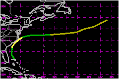
a. Synoptic HistorySatellite imagery showed an increase in cloudiness and showers
just east of the Bahamas on 16 June. This activity may have been associated
with a tropical wave that brought pressure falls to Puerto Rico and the
Dominican Republic on the previous day. On the 17th, increased organization
of the system at low levels was observed in surface data, animation of
satellite imagery and the first aircraft reconnaissance reports. The best
track indicates that the Atlantic's first tropical depression of the year
formed from this system at 1800 UTC, centered near the eastern end of
Grand Bahama Island. The depression initially moved toward the north-northwest
to north, steered by the low-level flow around the western periphery of
the Atlantic subtropical ridge. The depression experienced considerable
shear at this time due to strong upper-level winds associated with a cold
low over the eastern Gulf of Mexico. Deep convection increased in a small area mainly to the north
of the center on 18 June. The depression became Tropical Storm Arthur
at 0000 UTC on the 19th, based on analysis of reconnaissance data. Maximum
winds of 46 mph are based on a ship report received on this day. The storm
began to turn more toward the northeast with time. Arthur's center crossed over Cape Lookout, North Carolina
near 0000 UTC 20 June. As the storm continued moving toward the northeast,
locally heavy rains occurred over portions of the Carolinas in advance
of the cyclone's center. The center moved over the Pamlico Sound and the
Cape Hatteras National Seashore and exited into the Atlantic. Satellite
imagery indicated that the storm had a very well-defined low-level circulation
with minimal deep convection. It is likely that most of the tropical storm
force winds associated with Arthur remained offshore over the Atlantic
waters. The tropical storm weakened to a tropical depression about 100
nautical miles northeast of Cape Hatteras. Arthur began moving toward the east-northeast and accelerated
when westerly steering currents increased on the 20th. Deep convection
developed on 21 June, but the cloud pattern was not very symmetrical in
appearance, suggesting that the system was losing tropical characteristics.
Forward motion increased to greater than 40 mph and Arthur became an extratropical
gale at 1200 UTC 21 June while centered about 350 nautical miles north-northeast
of Bermuda. The remnant of Arthur was tracked for another 36 hours and
was last identified about midway between Newfoundland and the Azores,
where it was absorbed by a much larger extratropical low over the North
Atlantic. b. Meteorological StatisticsIntensity estimates derived from satellite data never exceeded
40 mph. The maximum wind reported by U.S. Air Force reserve aircraft was
52 mph at a flight-level of 1500 feet at 0023 UTC 19 June. The ship Atlantic
Huron reported a sustained wind of 48 mph at 1500 UTC 19 June while
located 35 nautical miles southeast of the cyclone's center. The C-MAN
station at Frying Pan Shoals reported sustained winds of 39 mph and a
gust to 46 mph at 1700 UTC on 19 June. This automated reporting station
is located about 30 nautical miles southeast of Cape Fear, North Carolina,
and the winds were measured at an elevation of approximately 80 feet.
A sustained wind of 38 mph and a gust to 45 mph were reported from Ocracoke
Island on the North Carolina Outer Banks at 0512 UTC 20 June. 1. Storm SurgeSurf as high as 5 to 7 feet occurred off the North Carolina coast in the vicinity of Cape Lookout. No significant beach erosion was reported.2. Rainfall DataThe largest rainfall total, 5 inches, occurred in Georgetown County, South Carolina. Several areas over the coastal plains of South Carolina and North Carolina reported between 2 and 4 inches.c. Casualty and Damage StatisticsNo reports of casualties or significant damage associated
with Arthur have been received at the NHC.
Maximum Intensity
For Tropical Storm Arthur
Landfall for
Tropical Storm Arthur
| ||||||||||||||||||||||||