|
|
|
|
|||||||||||||||||||||||||||||||||||||||
|---|---|---|---|---|---|---|---|---|---|---|---|---|---|---|---|---|---|---|---|---|---|---|---|---|---|---|---|---|---|---|---|---|---|---|---|---|---|---|---|
|
1996 PRELIMINARY
REPORTS |
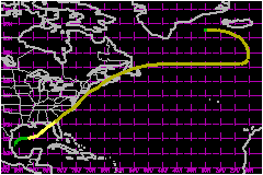
Josephine made landfall in the eastern Apalachee Bay, Florida area as a 69-mph tropical storm. a. Synoptic HistoryThe origin of Josephine does not appear to be directly related
to a tropical wave. On 29-30 September, a front, which had moved over
the southwestern Gulf of Mexico, stalled over that area. A broad area
of cloudiness and showers was noted over the southwest Gulf beginning
around this time. This disturbed weather appears to have been caused mainly
by the front, but could also be partially ascribed to a tropical wave
which passed over the extreme southern Gulf on 29 September. This wave
led to the formation of Hernan in the eastern Pacific. A broad area of
low pressure developed near the Bay of Campeche on 1-2 October, but upper-tropospheric
winds were only marginally favorable for development, and the associated
deep convection was not persistent until the 3rd. The surface circulation
became better defined on the 4th, on which day the system received its
initial Dvorak classification from the Tropical Analysis and Forecast
Branch (TAFB). Meanwhile, the strong pressure gradient between the low
and a large high pressure system centered near the Great Lakes began to
produce strong winds across the northern Gulf of Mexico. An Air Force Hurricane Hunter plane was dispatched to the
system on the afternoon of the 4th and data from the aircraft indicated
that a tropical cyclone, Tropical Depression Ten, had formed. Based on
aircraft, surface and satellite data, the estimated time of genesis is
1800 UTC 4 October. Initially, steering currents were weak and the depression
moved slowly north-northeastward on the 4th and 5th. Southwesterly shearing
was present over the system and there was no significant increase in organization
until the 6th. Even though the depression did not intensify during the
first couple of days of its existence, the strong pressure gradient persisted
over the northern Gulf, producing gale to storm force winds over that
area. By midday on the 6th, aircraft observations indicated that the central
pressure had dropped to 1001 mb. Banding features on satellite images
became better defined and it is estimated that the cyclone strengthened
into Tropical Storm Josephine at 1800 UTC 6 October. A strong mid-latitude, deep-layer trough began to dominate
the eastern half of the United States, and on the 6th and 7th the tropical
storm was steered eastward to northeastward, at an increasing forward
speed, on the southeast flank of this trough. Early on the 7th, Josephine
strengthened significantly and was nearing hurricane intensity. This development
trend proved to be temporary, however, as vertical shear began to increase
over the northeast Gulf. Josephine's cloud structure became more asymmetric,
with nearly all of the deep convection northeast of the center. The storm's
intensity leveled off at 69 mph. The center moved over Apalachee Bay on
the evening of the 7th, and crossed the coast in a relatively uninhabited
region of north Florida, in Taylor County, at about 0330 UTC on the 8th
of October. Josephine was already beginning to lose its tropical characteristics
when it crossed the coast, since temperature at Keaton Beach dropped about
6C in one hour shortly after the storm moved inland. The system became
an extratropical cyclone by the time it entered Georgia at 0600 UTC 8
October. The cyclone's forward speed increased dramatically, to near 46
mph, and the extratropical low raced northeastward near the U.S. east
coast, passing close to Cape Cod at 0600 UTC on the 9th. The low traversed
Nova Scotia and Newfoundland on 9-10 October, and then emerged over the
north Atlantic. It moved eastward for a day or two, slowing its forward
speed. Then the system tracked counter-clockwise within a deep-layer cyclonic
flow regime over the northeastern Atlantic on the 12th through the 15th.
Finally, the extratropical remnant of Josephine merged with a larger extratropical
cyclone in the vicinity of Iceland on 16 October. b. Meteorological StatisticsThe minimum central pressure reported in Josephine, by the
Hurricane Hunters, was 981 mb at 1135 UTC 7 October. Highest flight-level
(850 mb) winds near that time were 76 mph. The maximum flight-level wind
reported by reconnaissance aircraft was 85 mph at 0050 UTC 8 October.
Josephine's maximum surface winds were estimated to be 69 mph from 1200
UTC on the 7th up to landfall 16 hours later. Aircraft observations indicated
that, at most, a partial eyewall was present on three center fixes during
the above period. 1. Storm SurgeStorm surge heights were "significant" from the Tampa area northward to eastern Apalachee Bay. County officials estimated storm tides (storm surge plus astronomical tide) ranged from up to 9 feet in Levy county to 4 to 6 feet in Pinellas and Hillsborough Counties, and 3 feet as far south as Lee County. These tides produced widespread flooding of roads, dwellings, and businesses.2. Rainfall DataRainfall amount of up to 8.5 inches were reported over northern Florida in association with Josephine.3. TornadoesAccording to reports from National Weather Service Offices, at least 16 tornadoes occurred in association with Josephine over northern and central Florida. These caused mostly minor damage, primarily to trees. One tornado, however, had a 7 mile long, 400 yard wide track across Edgewater in Volusia County. It severely damaged 30 homes, while 100 others had minor damage.c. Casualty and Damage StatisticsTotal insured losses from Josephine in Florida, Georgia, South Carolina, North Carolina, and Virginia are estimated to be $65 Million. This gives a rough estimate of $130 Million for the total storm damage. There were no deaths that could be directly attributed to Josephine. A woman suffered a heart attack during a tornado in Edgewater, and a surfer suffered a broken leg in Pinellas County.
Maximum
Sustained Winds For Tropical Storm Josephine
Minimum
Pressure For Tropical Storm Josephine
Landfall
for Tropical Storm Josephine
| ||||||||||||||||||||||||||||||||||||||