|
|
|
|
|||||||||||||||||||||||||
|---|---|---|---|---|---|---|---|---|---|---|---|---|---|---|---|---|---|---|---|---|---|---|---|---|---|
|
1996 PRELIMINARY
REPORTS |
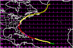
Bertha was an early-season Cape Verde Hurricane that moved across the islands of the northeastern Caribbean Sea as a category 1 hurricane on the Saffir/Simpson scale and made landfall on the North Carolina coast near Wilmington as a category 2 hurricane. Bertha's 1-minute winds reached their maximum value of 115 mph on 9 July, while located to the north of Puerto Rico. The last Hurricane to reach this strength, this early in the season, was Alma in 1966 in the eastern Gulf of Mexico with 127 mph. Bertha is responsible for an estimated eight deaths and $250 Million in U.S. damages. a. Synoptic HistoryBertha originated from a tropical wave which moved from Africa
to the Atlantic on 1 July. A weak circulation was first detected on satellite
imagery on 3 July, centered about 500 nautical miles south of the Cape
Verde Islands in the far eastern Atlantic Ocean. The track of the circulation
center begins on 5 July, when the circulation is believed to have reached
the surface and become a tropical depression, in the central tropical
Atlantic. Bertha followed a fairly smooth curved path around the western
periphery of the Atlantic subtropical high pressure ridge. This ridge
changed little during Bertha's existence and a weak mid-level trough persisted
in the western North Atlantic. For three days, the depression moved toward
the west-northwest at the fast forward speed of 23 to 29 mph and strengthened
to a hurricane with 1-min. maximum sustained winds of 86 mph on the 8th
as the center moved across the Leeward and Virgin Islands of the northeastern
Caribbean. The center moved between Antigua and Barbuda at 0600 UTC on
the 8th, across St. Barthelemy, Anguilla, and St Martin, just north of
St. Thomas, and over the British Virgin Islands by 1800 UTC. The track gradually turned northwestward on the 9th and maximum
sustained winds reached 115 mph at 0600 UTC. Bertha was centered 120 nautical
miles north of Puerto Rico at this time, but earlier passed within 30
nautical miles of this island. The strongest winds were located in the
northeast quadrant of the hurricane and most of Puerto Rico experienced
only tropical storm conditions, except for Culebra, over which hurricane-force
winds might have occurred. Moving northwestward at a slower forward speed of 17 to 23
mph, the center of Bertha moved parallel to the Bahama islands, passing
40 to 60 nautical miles northeast of the Turks and Caicos islands, San
Salvador, Eleuthera and the Abacos. Again, the strongest winds were located
to the northeast of the center, but 75-mph sustained winds might have
reached some of the above mentioned islands. Continuing on its gradual turn, the track became north-northwestward
on the 10th and 11th and the center moved parallel to the coast of Florida
and Georgia at a distance of 150 to 175 nautical miles offshore. During
this time, the forward speed slowed to about 9 mph. Moving northward and
re-accelerating to a forward speed of 17 mph, Bertha made landfall at
2000 UTC on the 12th on the coast of North Carolina, with the center crossing
the coast midway between Wrightsville and Topsail Beaches. The hurricane
had been gradually weakening since its top speed of 115 mph on the 9th
to 81 mph on the 11th. Then, in 12 hours just before landfall, the winds
increased to 104 mph, which is the estimated maximum 1-min. wind speed
at landfall. Bertha quickly dropped below hurricane strength when it moved
inland over eastern North Carolina. It then moved northeastward along the U.S. east coast, producing
46 to 58 mph sustained winds over land from northern North Carolina to
New England and 69 mph winds over nearby Atlantic waters. Bertha was declared
extratropical on the 14th when the center moved from the Maine coast to
New Brunswick, Canada. The extratropical storm brought 46 to 58 mph winds
to the Canadian Maritime Provinces and was tracked to just south of Greenland
on the 17th. b. Meteorological StatisticsThe minimum pressure of 960 mb occurred at 0600 UTC on the
9th and is based on a dropsonde measurement. The best track maximum sustained
wind speed of 115 mph at the same time is based on a 700-mb flight-level
wind speed of 140 mph, measured 19 nautical miles east-northeast of the
center. Observations are incomplete from the Leeward and Virgin Islands,
but because the circular eyewall was 20 - 30 nautical miles across, it
is believed that hurricane conditions with sustained wind speeds to 86
mph, could have occurred on Antigua, Barbuda, Nevis, St. Eustatius, St.
Bathelemy, Anguilla, St. Martin, and from St. Thomas northward through
the U.S. and British Virgin Islands. Experience with Hurricane
Marilyn in 1995 suggests that even higher sustained winds
can occur over mountainous terrain as is found on many of these islands.
Winds of 40 to 46 mph were experienced over portions of Puerto Rico as
indicated by the San Juan observations. A reconnaissance aircraft flight level wind speed of 127
mph in the northeast quadrant of the circulation several hours before
landfall is the basis for estimating sustained surface winds of 104 mph
on the coast at landfall. The lowest sea-level pressure observed at landfall
was 977 mb at Surf City, North Carolina and a value of 974 mb is assumed
to be the minimum pressure at landfall. 1. Storm SurgeCoastal storm surge flood heights, from Florida through New England, ranged from 1 to 4 feet, but values to 5 feet were estimated on the North Carolina coast from Cape Fear to Cape Lookout. A storm surge of 6 feet or a little higher is indicated near Swansboro, where 5 to 6 feet of water was "inside of businesses on the waterfront".(from Newport, North Carolina National Weather Service Forecast Office Preliminary Storm Report).2. Rainfall DataStorm total rainfall amounts ranged from 5 to 8 inches along a coastal strip from South Carolina to Maine.3. TornadoesSeven tornadoes have been confirmed, and these occurred during the passage of an outer rain band. There were five tornadoes in Virginia, one in North Carolina and one in Maryland.c. Casualty and Damage StatisticsTwelve deaths have been related, in some way, to Hurricane
Bertha. One, in Florida, was from an evacuating military jet crashing
into a house. One death from an auto accident occurred in North Carolina
and another drowned in rip currents. A surfer died in New Jersey. In Puerto
Rico, two died in an automobile accident and another died while surfing.
On the French half of St. Martin, one person was electrocuted and one
fell off a boat. The U.S. Virgin Islands, along with North Carolina, has been
declared a federal disaster area. Surveys indicate that Bertha damaged
almost 2500 homes on St. Thomas and St. John. For many, it was a second
hit in the ten months since Hurricane
Marilyn devastated the same area. It is likely that there was beach erosion on the north coast
of the Dominican Republic as Bertha passed to the north. The Bahamas were
also affected by the weak side of the hurricane, but there are no damage
figures available from either of these locations. The primary effects in North Carolina were to the coastal
counties and included storm surge flooding and beach erosion, roof damage,
piers washed away, fallen trees, and damage to crops. A survey indicated
over 5000 homes damaged, mostly from storm surge. A Federal Emergency
Management Agency (FEMA) estimate of the number of persons in South and
North Carolina who evacuated is 750,000. Minor wind damage and flooding
also spread along the path of the storm all the way to New England. The American Insurance Association reports an estimate of
$135 Million in insured property damage,
primarily along coastal North Carolina. A conservative ratio between total
damage and insured property damage, compared to past land falling hurricanes,
is two to one. Then the total U.S. damage estimate is 2 times $135
Million or $270 Million. No figures
are available from the Caribbean.
Maximum Intensity For Hurricane Bertha
Landfall for
Hurricane Bertha
| ||||||||||||||||||||||||