Hurricane Marilyn devastated portions of the U.S. Virgin Islands when
it hit that area with Category 2 to near Category 3 intensity on the
Saffir/Simpson Hurricane Scale (SSHS).
a. Synoptic History
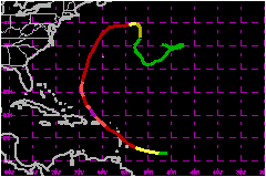
Marilyn originated from a tropical wave that crossed from the
west coast of Africa to the eastern tropical Atlantic Ocean on 7-8 September.
A large circulation of low- and middle-level clouds accompanied the wave,
but little deep convection was generated at that time. The system moved
westward at about 20 mph over the following few days, under upper-level
easterlies on the south side of a well-defined anticyclone aloft, which
also moved westward.
The initial Dvorak technique T-number intensities of 1.0 were
assigned late on the 11th by satellite analysts at the National Hurricane
Center (NHC) and the NESDIS Synoptic Analysis Branch (SAB). Although the
low-level circulation was rather disorganized then, deep convection developed
and became concentrated near the analyzed center on the 12th. Based on
analysis of satellite pictures, it became the fifteenth 1995 Atlantic
tropical depression at 1800 UTC on the 12th. The cyclone strengthened
further, becoming Tropical Storm Marilyn six hours later. Marilyn reached
hurricane strength 4 hours after that, at 0000 UTC on the 14th, shortly
after the U.S. Air Force Reserves (Hurricane Hunters) first identified
a closed eyewall during their reconnaissance flight.
Over the following three days, the track gradually became directed
toward the west-northwest and then the northwest while the hurricane moved
toward a weakness in the subtropical ridge over the central Atlantic Ocean.
Marilyn continued to strengthen in an "embedded center" cloud pattern,
but at a slower rate during that period. It was a Category 1 hurricane
on the 14th when the center passed about 45 nautical miles to the north
of Barbados, then just north of Martinique, over Dominica, to just southwest
of Guadeloupe.
Marilyn continued moving northwestward over the northeastern
Caribbean Sea. It hit the U.S. Virgin Island during the afternoon and
night of the 15th as a strengthening Category 2, nearly Category 3, hurricane.
The Hurricane Hunters reported hail, an unusual occurrence for tropical
cyclones. They noted an eye of 20 nautical mile diameter. The strongest
part of the hurricane, the eyewall to the east and northeast of the center,
passed over St. Thomas. Maximum 1-minute surface winds at that time were
close to 95 knots.
After passing just offshore from eastern Puerto Rico early
on the 16th, the center of Marilyn was again over the Atlantic Ocean.
An upper-level low had developed to the west and this could have enhanced
outflow aloft from Marilyn. An eye became distinct on satellite pictures
and Marilyn reached its peak intensity, about 949 mb and 115 mph (Category 3) as it began to turn northward on
the 17th. Flight-level data showed some evidence of a concentric pair
of eyewall wind maxima. Reconnaissance data indicated a marked weakening
later that day. The central pressure rose 20 mb in about 10 hours and
the peak flight-level winds decreased from 139
to 102 mph. The primary (inner) eyewall disintegrated
into a few fragments. The weakening was likely caused by some combination
of shearing within the system reported by the flight crew, the impact
of nearby waters upwelled not long before by Hurricane Luis
that were 1 to 3C cooler than normal, and the decaying phase of an eyewall
cycle.
Marilyn began accelerating toward the north-northeast late
on the 18th and its center passed about 150 nautical miles to the west
of Bermuda a day later. It had made a brief resurgence, with an eye reappearing
in satellite pictures. However, upper-level westerly winds then began
to shear Marilyn and the low-level cloud center became partially exposed.
Marilyn ceased generating deep convection late on the 21st and became
extratropical on the 22nd. The remnant circulation meandered over the
central tropical Atlantic Ocean for another 10 days before becoming absorbed
in a frontal system.
b. Meteorological Statistics
Surface meteorological data during Marilyn's passage over Dominica
are not available at the NHC.
Over Martinique and Guadeloupe, the maximum wind speed (presumably,
sustained over the WMO-standard of 10-minutes) was 59 mph with gusts between 81 and 86
mph.
Part of Marilyn's eye passed over St. Croix. However, owing
to the northwestward motion of the hurricane, Marilyn's strongest winds
were located in the eastern or northeastern eyewall which passed just
offshore. The highest 1-minute wind speed (estimated for open exposure
at 10 meters elevation) at St. Croix was likely a little less than the
85 knots shown in the best track.
On the other hand, St. Thomas was hit by the hurricane's eastern
and northeastern eyewall. In addition, the hurricane strengthened as it
approached and passed St. Thomas. An uncommissioned FAA Automated Surface
Observing System (ASOS) at the St. Thomas King Airport provided the only
continuous "official" wind record of the event in the U.S. Virgin Islands.
Its maximum 2-minute wind was 104 mph at 0352 and again at 0353 UTC on the 16th. (Around
then, the peak 10-second winds in the hurricane at the 700 mb flight-level
were 121 to 127 mph.) The ASOS measured a gust
to 129 mph at 0408 UTC. Based on the ASOS data,
the estimated maximum 1-minute wind speed (for open exposure at 10 meters
elevation) at that time is 109 mph. This is 5
knots higher than was estimated operationally. It is likely that somewhat
stronger 1-minute winds (perhaps, to Category 3) and gusts above 129
mph occurred on exposed hills. Some unofficial high wind speed
observations remain unconfirmed or have been rejected.
The ASOS measured a minimum pressure of 956.7 mb. This occurred
at 0422 UTC when the airport was still experiencing 69 mph 1-minute winds, apparently on the inside edge
of the eyewall. The estimated minimum pressure for Marilyn at that time
is 952 mb. This is lower than implied by the data obtained from the Hurricane
Hunters. They reported extrapolated and dropsonde pressures of 957 and
960 mb, respectively, at 0305 UTC, and 954 and 958 mb for those techniques
at 0600 UTC. This is reminiscent of Hurricane
Andrew's landfall over Florida, where the minimum pressure
obtained from surface observations was lower than analyzed using aircraft
data. The reason for this discrepancy in Marilyn is not obvious.
An unofficial gust to 125 mph was
reported from the island of Culebra.
The center of Marilyn passed far enough to the east of Puerto
Rico that hurricane conditions were apparently not experienced on that
island. The Naval Base at Roosevelt Roads had maximum 1-minute winds of
41 knots with gusts to 58 mph.
Bermuda experienced sustained winds of 45
mph with a gust to 60 mph during the passage of Marilyn's outer
circulation.
1. Storm Surge Data
The storm surge in the U.S. Virgin islands reached 6 to
7 feet, with an isolated storm tide of 11.7 feet reported on St. Croix.
Rainfall totals reached about 10 inches in St. Croix and St. Thomas.
2. Rainfall Data
Guadeloupe had exceptionally heavy rain, with one station,
Saint-Claude, recording 20.00 inches in a 12-hour period. The maximum
rainfall reported from Martinique was about 9 inches.
c. Casualty and Damage Statistics
There were 8 deaths attributed to Marilyn; 5 in St. Thomas,
1 in St. John, 1 in St. Croix and 1 in Puerto Rico.
Marilyn caused severe damage to the U.S. Virgin Islands, in
particular to St. Thomas. An estimated 80 percent of the homes and businesses
on St. Thomas were destroyed and at least 10,000 people were left homeless.
Some of the damage was reportedly attributable to lax construction standards
and practices. According to FEMA, 30 percent of the homes on St. John
were destroyed and 60 percent were roofless. About 20 to 30 percent of
homes in St. Croix received damage. Trees fell and hotel windows broke
there. Hillsides were littered with sheets of metal roofing, wooden planks
and household debris. On Culebra, 250 homes were destroyed or severely
damaged and light planes were overturned.
Large waves crashed over the harbor at Dewey, Culebra, flooding
streets. Flash floods occurred over northern and eastern Puerto Rico where
the La Plata and Manati rivers overflowed.
The American Insurance Services Group estimated insured losses
for the U. S. Virgin Islands and Puerto Rico at $875
Million. Because the overall loss is often estimated to be up to
about double the insured loss, the total U.S. loss is tentatively estimated
at $1.5 Billion. The U. S. Virgin Islands
Bureau of Economic Research estimated the economic loss at $3
Billion. FEMA placed the cost for their programs at $1
Billion in the Virgin Islands and $50 Million
in Puerto Rico. The FEMA totals include losses not traditionally described
by the NHC as "damage", such as FEMA's cost to set up field offices, inspector's
salaries, disaster unemployment compensation, and crisis counseling.
According to The New York Times, the British Virgin Islands
were not seriously affected and some (unquantified) damage occurred in
Antigua. According to the Antigua Meteorological Service, that island
had extensive flooding in low-lying areas, destruction of banana trees
and, otherwise, minimal wind damage.
About 12,000 people went to shelters in Puerto Rico. In the
U.S. Virgin Islands, 2,243 people were sheltered.
Maximum Intensity For Hurricane Marilyn
12 September - 01 October, 1995
Date/Time
(UTC) |
Position |
Pressure
(mb) |
Wind Speed
(mph) |
Stage |
| Lat. (°N) |
Lon. (°W) |
| 17/0300 |
20.7 |
67.1 |
949 |
115 |
Category 3 Hurricane |
Landfall for
Hurricane Marilyn
12 September - 01 October, 1995
Date/Time
(UTC) |
Pressure
(mb) |
Wind Speed
(mph) |
Stage |
Landfall |
| 14/2100 |
984 |
80 |
Category 1 Hurricane |
Jenny Point,
Dominica |
|