|
|
|
|
|||||||||||||||
|---|---|---|---|---|---|---|---|---|---|---|---|---|---|---|---|
|
1995 PRELIMINARY
REPORTS |
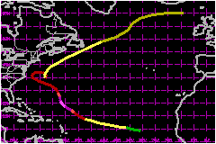
a. Synoptic HistoryA tropical wave moved off the African coast on 6 August. Satellite
imagery indicated that it quickly displayed evidence of a circulation
as it moved toward the west. The post-analysis "best track" shows that
the disturbance became Tropical Depression Seven about 400 nautical miles west-southwest
of the Cape Verde Islands at 0000 UTC 8 August when loosely organized
deep convection increased. The depression strengthened into Tropical Storm Felix later
on the 8th and followed a west-northwestward track at 17-23 mph for the
next three days. Based on satellite intensity estimates, Felix reached
hurricane strength at 0000 UTC 11 August while centered about 500 nautical miles
east-northeast of the Leeward Islands. Reports from reconnaissance aircraft
indicated rapid strengthening from the time of the first eye penetration
near 1200 UTC on the 11th through the 12th. Maximum sustained surface
winds of 138 mph are estimated to have occurred
near 1800 UTC 12 August. A well-defined eye was visible in satellite imagery
at this time. Felix moved northwestward on 12 August, and then turned more
toward the north and started to weaken on 13 August. Two factors likely
contributed to the weakening: 1) Felix went through a concentric eyewall
cycle, and 2) wind shear increased over the system when Felix's upper-level
anticyclone didn't remain centered over the lower-level cyclonic circulation.
Aircraft data on the 13th when Felix was centered 300 to 400 nautical miles south-southeast
of Bermuda indicated a large wind field with several wind maxima and no
tight center. These characteristics would persist for much of the remainder
of the storm's life. Felix's northward turn was due to a large deep-layer trough
over the western Atlantic. The trough split as Felix approached, with
one part moving northeastward and filling and the other moving southward
to the southwest of the hurricane. The resulting steering pattern allowed
Felix to resume a general northwestward motion by 15 August, with this
motion persisting into the next day. This track took the storm center
within 65 nautical miles of Bermuda and toward the North Carolina coast. The split in the trough resulted in increased ridging over
the western Atlantic that appeared to be strong enough to drive Felix
into the eastern United States. However, a small weakness remained between
70 and 75°W as indicated by Air Force and NOAA reconnaissance data on
the 16th. Felix turned northward into the weakness and almost stalled
late on the 16th. It then moved slowly northeastward on 17 August. A second
westerly trough failed to pick up the storm on 18-19 August, and Felix
performed an anticyclonic loop offshore as the trough bypassed the tropical
cyclone. The hurricane accelerated northward on 20 August and northeastward
on 21 August in response to a third trough. During 17-19 August, Felix had a 50-70 nautical miles wide eye on aircraft
radar and rather weak convection in satellite imagery. Despite this, the
storm maintained 75-81 mph sustained winds and
a central pressure near 970 mb. It is possible that this structure was
due to cooler, drier air entering the circulation at low and mid levels.
Felix dropped below hurricane strength on 20 August as it moved over colder
water and shearing again increased. Felix became extratropical about 300 nautical miles east-northeast of
Newfoundland on 22 August. The extratropical cyclone was tracked across
the North Atlantic between Scotland and Iceland and then toward Norway. On a historical note, the threat of Hurricane Felix postponed
Bermuda's scheduled vote for independence. Ironically, the first inhabitants
at Bermuda were survivors of a hurricane-caused shipwreck on the island
in 1609. Their stories helped inspire Shakespeare's writing of The Tempest. b. Meteorological Statistics U.S. Air Force Reserve aircraft provided a total of 70 operational
center fixes on Felix. The 24 missions and approximately 280 flying hours
of reconnaissance on this hurricane are both records for an Atlantic tropical
cyclone. The maximum winds of 164 mph from a flight-level
of 700 mb were measured at 1254 UTC 12 August. The minimum central pressure
reported by aircraft was 930 mb at 2328 UTC 12 August, and it is likely
that the pressure was somewhat lower during the previous 10 hours when
there were no aircraft measurements. In addition to the Air Force Reserve
reconnaissance, two NOAA aircraft flew a research mission on 16 August. During most of the 15th and 16th, the minimum central pressure
hovered between 965 and 970 mb, which would normally be consistent with
98-115 mph surface winds. However, maximum flight-level
winds reported by reconnaissance aircraft were only 75
to 86 mph at 850 and 700 mb. This would suggest a minimal hurricane
at most. The rawinsonde at Bermuda indicated 63 mph
surface winds with 92 mph at 400 feet. Because a large component of these
winds were probably brought to the surface in strong convective bands,
the maximum sustained surface winds are estimated at 81-86 knots during this time. Numerous ship reports were received in the vicinity of Felix
and were helpful in defining the extent of tropical storm force winds. Bermuda reported a minimum pressure of 988.1 mb and maximum
sustained winds of 63 mph with gusts to 81 mph at 0000 UTC 15 August as the center of Felix
passed about 65 nautical miles to the south- southwest. No sustained tropical storm
force winds were reported by U.S. land stations. Wind gusts to 43
mph were reported from the NWS office at Buxton, North Carolina
at 2058 UTC 16 August and at 0102 UTC 17 August while the hurricane was
centered about 125 nautical miles to the east. The eye of Felix passed over NOAA buoy 41001 located at 34.7°N
72.6°W, about 150 nautical miles east of Cape Hatteras, near 1600 UTC 16 August.
The buoy reported a 970.4 mb pressure at this time with light winds. A
10-minute average wind of 61 mph and gusts to
76 mph were reported earlier by the buoy near
1200 UTC. Rain bands associated with Hurricane Felix remained offshore
of the U.S. coast. Although the strong winds and heavy rains did not directly
affect the United States, large swells generated by Felix produced dangerous
surf conditions including some coastal flooding and rip currents from
northeastern Florida to New England. Isolated areas of severe beach erosion
occurred along the New Jersey coast, but the most significant beach erosion
occurred on the Outer Banks of North Carolina. Highway 12 on the Outer
Banks was flooded with sand and ocean overwash at times of high tides.
Beach nourishment occurred in some coastal areas of North Carolina to
the southwest of the Outer Banks.
c. Casualty and Damage StatisticsThere were 8 deaths attributed to Felix; 3 in North Carolina
and 5 in New Jersey. Although there was considerable beach erosion, little significant property damage occurred.
Maximum Intensity For Hurricane Felix
| ||||||||||||||