|
|
|
|
|||||||||||||||||||||||||
|---|---|---|---|---|---|---|---|---|---|---|---|---|---|---|---|---|---|---|---|---|---|---|---|---|---|
|
1995 PRELIMINARY
REPORTS |
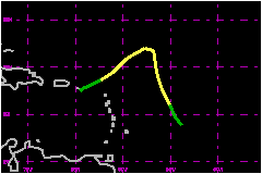
a. Synoptic HistoryTropical Storm Sebastien originated from a tropical wave that
moved westward across the Atlantic Ocean from the 13th through the 19th
of October. Associated thunderstorms remained unorganized and mostly to
the south of 15N during that period. On the 20th, deep convection became
more concentrated about 350 nautical miles to the east of Barbados. Dvorak technique
T-numbers were first assigned on that date by meteorologists at the National
Hurricane Center's Tropical Analysis and Forecast Branch (TAFB, formerly
TSAF as in figures) and the NESDIS Synoptic Analysis Branch (SAB), and
within 24 hours increased to 2.5. Based on their analyses, it is estimated
that the system became a tropical depression at 1200 UTC on the 20th and
a tropical storm at 0000 UTC on the 21st. From the 20th to the 22nd, Sebastien was embedded within the
outer part of the circulation associated with a large, deep low- pressure
system centered just northeast of Puerto Rico. The associated steering
currents moved Sebastien toward the northwest to north at about 17 mph
during that period. Southwesterly vertical wind shear precluded significant
development and, based on a ship observation, Sebastien reached its peak
intensity of 63 mph, at 1800 UTC on the 22nd.
At that time, its exposed low-level cloud center was located about 350
nautical miles to the northeast of the northern Leeward Islands. Sebastien began moving with the low-level flow toward the southwest on the 23rd. This pushed Sebastien directly into the upper-level southwesterly winds, displacing the coldest cloud tops about 100 nautical miles to the east and northeast of the center. Sebastien weakened to a tropical depression during the evening of the 23rd while it moved under the upper-level cyclonic circulation. Its dissipating circulation of low clouds was near the U.S. Virgin Islands about 24 hours later, while some remnant deep convection persisted well to the east. b. Meteorological Statistics Sebastien did not cause tropical storm conditions over land. The basis for the estimated maximum wind speed of 63 mph is a 60 mph wind observed on the ship with call sign ELSE5 while it was located 60 nautical miles northeast of the center at 1800 UTC on the 22nd. The maximum flight-level wind at 1500 feet came at about this time and was 58 mph. The only other reports of 39 mph or higher wind speeds came from the ship Sea Wolf. It had 41 and 44 mph winds at 1200 and 1400 UTC, respectively, on the 21st, 35 to 45 nautical miles to the east of the circulation center. c. Casualty and Damage StatisticsNo reports of casualties or damages were received by the
NHC.
Maximum Intensity
For Tropical Storm Sebastien
Landfall for
Tropical Storm Sebastien
| ||||||||||||||||||||||||