|
|
|
|
|||||||||||||||||||||||||
|---|---|---|---|---|---|---|---|---|---|---|---|---|---|---|---|---|---|---|---|---|---|---|---|---|---|
|
1995 PRELIMINARY
REPORTS |
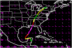
a. Synoptic HistorySatellite imagery and synoptic analyses indicate that Opal
originated from a tropical wave that emerged from the west coast of Africa
on 11 September. The wave moved westward across the Atlantic into the
western Caribbean Sea by 23 September and merged with a broad area of
low pressure centered in the vicinity of 15N� 80�W. The combined system
drifted west-northwestward toward the Yucatan peninsula over the following
few days without significant development. Deep convection increased near
the center of the low and the post-analysis "best track" shows that a
tropical depression formed about 70 nautical miles south-southeast of
Cozumel, Mexico at 1800 UTC 27 September. Steering currents were weak and the tropical depression moved
slowly over the Yucatan peninsula for the following three days. Convective
banding increased and ship reports suggest that the depression became
Tropical Storm Opal at 1200 UTC 30 September while centered near the north-central
coast of the Yucatan peninsula. The storm gradually strengthened and moved
slowly westward into the Bay of Campeche. Air Force Reserve unit aircraft investigating Opal over the
southwestern Gulf of Mexico reported that the minimum central pressure
steadily dropped. Aircraft reports and satellite estimates suggest that
Opal strengthened into a hurricane near 1200 UTC 2 October while centered
about 150 nautical miles west of Merida, Mexico. A banding type eye appeared
in satellite imagery later in the day while a large amplitude mid- to
upper-level trough moving into the central United States began turning
Opal slowly toward the north. On 3 and 4 October, the hurricane turned toward the north-
northeast to northeast and gradually accelerated. During this period,
the water temperature beneath the hurricane's circulation was near 28
to 29C, and a large upper-level anticyclone was well established over
the Gulf of Mexico. Rapid intensification occurred not only as a result
of these favorable environmental conditions on the large scale but, and
perhaps more importantly, due to significant changes on a smaller scale
within the hurricane's inner core. Opal intensified into a category four
hurricane on the Saffir/Simpson Hurricane Scale early on 4 October at
which time reconnaissance aircraft reported a small, 10 nautical mile
diameter eye. The minimum central pressure of 916 mb, with maximum sustained
surface winds estimated at 150 mph, occurred when the hurricane was centered about
250 nautical miles south-southwest of Pensacola, Florida near 1000 UTC
4 October. The peak intensity appears to have occurred near the end of
an eyewall contraction cycle. Soon thereafter, the small inner eyewall
diminished as an outer eyewall became more dominant. The hurricane weakened
during this process, but was still a marginal Category 3 hurricane as
the center made landfall at Pensacola Beach, Florida near 2200 UTC 4 October.
The collapse of the inner eyewall, reduced sea surface temperatures along
the Gulf coast and increased upper-level westerlies likely contributed
to the weakening. The hurricane was moving north-northeastward near 23 mph at
landfall with the sustained hurricane force winds in the eastern quadrants
of the circulation primarily between Pensacola Beach and Cape San Blas.
The minimum central pressure at landfall was 942 mb. Maximum sustained
surface winds are currently estimated at 115 mph in a narrow swath at the coast near the extreme
eastern tip of Choctawhatchee Bay about midway between Destin and Panama
City. Although no official reports of surface winds were received
within this area, data from reconnaissance aircraft and Doppler radar
suggest that the peak winds occurred in this location. It should be emphasized
that the strongest winds were in a very limited area and most of the coastal
areas of the Florida panhandle experienced winds of a Category 1 or Category
2 hurricane (between 75 and 109 mph). Although the winds were diminishing
at the time of landfall, extensive damage due to storm surge and breaking
waves occurred over most of the coastal areas of the Florida panhandle.
Opal weakened rapidly after moving inland, becoming a tropical
storm over southern Alabama and a tropical depression over southeastern
Tennessee. The cyclone was declared extratropical on the best track as
it moved northeastward over the Ohio Valley and eastern Great Lakes into
southwestern Quebec. The strongest winds occurred well away from the center
of the cyclone during the extratropical stage. b. Meteorological Statistics
| ||||||||||||||||||||||||
| Date/Time (UTC) |
Position | Pressure (mb) |
Wind Speed (mph) |
Stage | |
|---|---|---|---|---|---|
| Lat. (°N) | Lon. (°W) | ||||
| 04/1000 | 26.6 | 88.8 | 916 | 150 | Category 4 Hurricane |
Landfall for
Hurricane Opal
27 September - 06 October, 1995
| Date/Time (UTC) |
Pressure (mb) |
Wind Speed (mph) |
Stage | Landfall |
|---|---|---|---|---|
| 04/2200 | 942 | 115 | Category 3 Hurricane | Pensacola Beach, Florida |