|
|
|
|
||||||||||||||||||||||||||||||||||||||||||||
|---|---|---|---|---|---|---|---|---|---|---|---|---|---|---|---|---|---|---|---|---|---|---|---|---|---|---|---|---|---|---|---|---|---|---|---|---|---|---|---|---|---|---|---|---|
|
1995 PRELIMINARY
REPORTS |
a. Synoptic HistoryThe NHC surface analysis showed a weak 1019 mb frontal low
midway between Bermuda and the South Carolina coast at 0600 UTC 5 July.
Maximum sustained winds around the low were 12 to 23 mph based on available
ship reports. Satellite imagery indicated that the clouds associated with
the low gradually became isolated from the frontal cloud band over the
next 24 to 36 hours. The satellite imagery also revealed that a low- level
cloud system center became better defined just to the west of a small
cluster of deep convection, and it is estimated that the frontal low transformed
into Tropical Depression Two near 1800 UTC 6 July. Upper-level westerly
shear was evident from the small area of deep convection remaining displaced
to the east of the low- level center. Little overall movement was noted
on 5 and 6 July. The center of circulation became better defined by a curved
low- to mid-level cloud band, and post-analysis suggests that the depression
strengthened into Tropical Storm Barry near 0600 UTC 7 July. During the
day, the storm began moving toward the north-northeast near 10 knots.
This allowed the storm-relative shear to decrease and deep convection
to move cyclonically around the western semicircle of the circulation.
The deepest convection moved from just north through west to south of
the circulation center. The presence of a negatively tilted mid- to upper-level
trough just to the southwest of Barry appears to have favored the temporary
increase in convection. The maximum sustained winds are estimated to have occurred
near 2100 UTC 7 July. At this time, an Air Force Reserve unit aircraft
reported hurricane force winds at a flight-level of 1500 feet, but the
minimum central pressure of 998 mb reported by the plane does not appear
to support sustained hurricane strength. Central convection decreased
dramatically after the strong winds were reported, and it is assumed that
the aircraft winds were associated with a transitory mesoscale feature. Satellite imagery revealed a cloud-free center within relatively
weak surrounding convection by 0000 UTC 8 July. The next aircraft reconnaissance
report indicated that the minimum central pressure had changed little,
but the maximum flight-level winds had decreased about 46 mph from those
that were measured the previous day. By 1800 UTC 8 July, a small area
of deep convection had developed near the low-level circulation center.
The storm began accelerating toward the north-northeast in advance of
a large amplitude trough moving eastward over the eastern United States.
The central dense overcast grew until near 1200 UTC on 9 July. Some of
this increase in convection may have been related to the passage of Barry
over a warm water eddy that bulged northward from the Gulf Stream to near
42�N between 63-66�W. Convection associated with Barry began to weaken as the tropical
cyclone continued to accelerate toward the north-northeast over cooler
water. The maximum winds began to spread out away from the cyclone center
as Barry gradually lost tropical characteristics, although upper-air soundings
indicated that the cyclone still exhibited a warm core when it passed
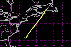
near Sable Island. The center of the storm crossed the eastern tip of
the peninsula of Nova Scotia, near Hart Island, around 2130 UTC 9 July
and then continued north-northeastward over Cape Breton Island. Barry
became extratropical near the western coast of Newfoundland shortly after
0600 UTC 10 July. As a weakening extratropical cyclone, it could be tracked
to near the southeast coast of Labrador before losing its identity. b. Meteorological Statistics On 9 July, Hart Island, Nova Scotia, reported 990.8 mb at
2145 UTC and Fourchu Head, Nova Scotia, reported 990.6 mb at 2248 UTC.
The minimum central pressure curve is anchored to these surface reports
and to the reports from aircraft reconnaissance on 7 and 8 July. The maximum wind reported by aircraft was 99 mph at a flight-level of 1500 feet at 2050 UTC 7
July. The latest available satellite wind estimates at that time were
40 mph from both the NHC and the NESDIS Synoptic
Analysis Branch (SAB). The satellite wind estimate was 30 knots from the
Air Force Global Weather Central (AFGWC) a few hours before and after
the maximum winds reported by aircraft. Similar scatter occurred between
the satellite estimates and the aircraft measurements of maximum winds
on 8 July as well. At 1200 UTC, the NHC satellite analyst estimated 75 mph while the SAB analyst estimated 52 mph. At 1438 UTC, the analyst at the AFGWC estimated
35 mph. At 1328 UTC, the aircraft reported maximum winds of 49 mph at a flight-level of 1500 feet. Given the large
amount of scatter in maximum wind information, there is obviously considerable
uncertainty in the best track wind speed on Tropical Storm Barry. c. Casualty and Damage StatisticsNo reports of casualties or damage associated with Barry have been received at the NHC.
Maximum
Sustained Winds For Tropical Storm Barry
Minimum
Pressure For Tropical Storm Barry
Landfall
for Tropical Storm Barry
| |||||||||||||||||||||||||||||||||||||||||||