|
|
|
|
|||||||||||||||||||||||||||||
|---|---|---|---|---|---|---|---|---|---|---|---|---|---|---|---|---|---|---|---|---|---|---|---|---|---|---|---|---|---|
|
1995 PRELIMINARY
REPORTS |
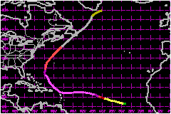
a. Synoptic HistoryLuis was first detected as a tropical wave and circulation
of low clouds on 26 August over the far eastern tropical Atlantic between
the coast of Africa and the Cape Verde Islands. The low- level cloud circulation
moved westward and is estimated to have developed a weak surface circulation
on the 27th near the Cape Verde Islands. While Luis was developing, there were three other tropical
cyclones in the Atlantic, to the west and northwest...Humberto, Iris and Karen. Luis strengthened from a depression to
a storm on the 29th, but its deep convection fluctuated for the next two
days while there was strong vertical shear nearby. The shear diminished
on the 30th; an eye formed and Luis quickly became a hurricane. The intensification
process continued for the next two days as Luis moved west-northwestward.
A reconnaissance aircraft reached the hurricane late on the 3rd of September
and confirmed the satellite intensity estimates of a category 4 hurricane
on the Saffir/Simpson scale. Luis was located about 600 nautical miles
east of the Lesser Antilles at this time. The track heading turned from westward to northwestward on
the 5th and the hurricane moved across the northeastern Leeward Islands.
The center passed directly over Barbuda and close enough to the northeast
of Antigua, St. Barthelemy, St. Martin and Anguilla that the southern
portion of the eyewall affected these islands. Luis' sustained winds in
the eyewall were as high as 132 mph at this time,
just below 138-mph maximum values which had occurred for the previous
48 hours. Luis was a large hurricane. The inner diameter of the eyewall
was 40 nautical miles as it moved over the islands. In addition to the
eyewall conditions described above, Nevis, St. Kitts, St. Eustatius and
the northernmost British Virgin Islands experienced hurricane-force wind
speeds, while tropical storm conditions affected the remainder of the
British and U.S. Virgin Islands and the eastern islands of Puerto Rico. Luis gradually recurved across the north Atlantic. The center
of the hurricane passed about 200 miles west of Bermuda on the 9th of
September, causing tropical storm force winds there. Luis became extratropical
on the 11th, as it moved over eastern Newfoundland, where high winds and
sea conditions were also reported. b. Meteorological Statistics
| ||||||||||||||||||||||||||||
| Date/Time (UTC) |
Position | Pressure (mb) |
Wind Speed (mph) |
Stage | |
|---|---|---|---|---|---|
| Lat. (°N) | Lon. (°W) | ||||
| 05/0600 | 17.3 | 61.0 | 939 | 140 | Category 4 Hurricane |
Minimum
Pressure For Hurricane Luis
27 August September - 12 September, 1995
| Date/Time (UTC) |
Position | Pressure (mb) |
Wind Speed (mph) |
Stage | |
|---|---|---|---|---|---|
| Lat. (°N) | Lon. (°W) | ||||
| 08/0000 | 24.3 | 68.0 | 935 | 125 | Category 3 Hurricane |