|
|
|
|
|||||||||||||||
|---|---|---|---|---|---|---|---|---|---|---|---|---|---|---|---|
|
1995 PRELIMINARY
REPORTS |
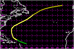
a. Synoptic HistoryChantal originated from a tropical wave which moved off of
the coast of Africa on 5 July and soon showed signs of a low level cloud
circulation. On the 12th, satellite imagery showed enough organization
for the system to be upgraded to a tropical depression while it was located
a few hundred miles east of the Lesser Antilles. An aircraft investigated
on the 13th and confirmed the existence of a depression. Even though there were signs of unfavorably strong upper level
westerlies, the depression strengthened to a storm on the 14th, while
centered a little over 200 nautical miles north-northeast of Puerto Rico.
On the 15th, it threatened the southeast and central Bahamas as it was
moving west-northwestward, but it gradually re-curved toward the north
on the 16th and 17th and did not directly affect the Bahamas. The storm's maximum 1-minute surface wind of 69 mph is estimated to have been reached on the 17th
as it was moving northward between Bermuda and the U.S. mid Atlantic coast.
Although there was a brief threat to Bermuda, the center passed well to
the west of there on the 18th. Chantal turned toward the northeast and
accelerated across the North Atlantic shipping lanes where it became extratropical
on the 20th.
b. Meteorological Statistics The storm was monitored by Air Force Reserve Unit reconnaissance
aircraft from the 13th to the 18th. There were 40 penetrations into the
center of the storm during this period, which averages to one fix every
three hours. The lowest surface pressure reported from an aircraft was
991 mb at 2338 UTC on the 16th and the maximum wind speed was 77 mph at a flight level of 1500 feet a few hours earlier.
c. Casualty and Damage StatisticsNo reports of casualties or damage have been received in connection with Chantal.
Maximum Intensity
For Tropical Storm Chantal
| ||||||||||||||