|
|
|
|
||||||||||||||||||||||||||||||||||||||||||||
|---|---|---|---|---|---|---|---|---|---|---|---|---|---|---|---|---|---|---|---|---|---|---|---|---|---|---|---|---|---|---|---|---|---|---|---|---|---|---|---|---|---|---|---|---|
|
1995 PRELIMINARY
REPORTS |
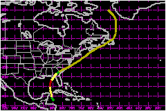
a. Synoptic HistorySatellite images and rawinsonde data show that a tropical
wave passed over the Windward Islands on 28 May. When the wave entered
the western Caribbean Sea on 1 June, it was accompanied by a broad mid-level
cyclonic circulation, which rawinsonde observations indicated was particularly
distinct at 700 mb. Convective cloudiness acquired sufficient organization
to warrant an initial Dvorak satellite classification at 0000 UTC 2 June.
At that time, the cloud cluster was located a few hundred miles to the
east of Honduras. The system moved north-northwestward, and gradually
became better organized during the daylight hours of the 2nd. The first
reconnaissance flight into the area revealed that the system became a
tropical depression around 0000 UTC on 3 June, centered 230 nautical miles
east of Belize City. Continuing on its north-northwestward heading, the cyclone
strengthened into Tropical Storm Allison at 1200 UTC on the 3rd. The intensifying
storm turned northward, and moved through the Yucatan Channel. The storm
deepened even though southwesterly upper-level winds were creating a shearing
environment. In fact, by 1200 UTC on the 4th, Allison became a 75-mph hurricane over the southeast Gulf of Mexico,
centered 240 nautical miles west of Key West. However, the strengthening
trend soon ceased and Allison never developed beyond minimal hurricane
intensity. Moving northward near 17 mph, Allison headed for the Florida
panhandle. Early on 5 June, as the system drew nearer to the coast, it
turned northeastward, and weakened slightly, apparently in response to
south-southwesterly vertical shear. Allison's winds dropped just below
hurricane force by 0600 UTC 5 June. Landfall occurred at 1400 UTC 5 June
on the coast of north Florida, near Alligator Point, and again (after
a very brief time over water) at 1500 UTC near Saint Marks. Maximum winds
at landfall are estimated at 63-69 mph. The storm
weakened further as it headed inland to Georgia, but tropical storm force
winds persisted over Apalachee Bay until 2100 UTC on the 5th. Allison
diminished to a tropical depression over southern Georgia by 0000 UTC
6 June. By 0600 UTC on the 6th, the system acquired extratropical characteristics as it interacted with a warm frontal zone to the northeast. Gale force winds developed along the Georgia and South Carolina coasts as the cyclone's isobaric pattern expanded and the pressure gradient increased well east of the low center. During the day on the 6th, the low moved northeastward over the coastal plain of the southeastern U.S., emerging into the Atlantic a little north of Cape Hatteras just after 0000 UTC 7 June. The low, with an associated area of gale to storm force winds over its southeastern semicircle, moved rapidly northeastward, skirting the eastern shore of Nova Scotia on the 8th, as it headed for Newfoundland. After passing over Newfoundland on the 9th, the gale center turned northward, and then north-northwestward, crossing the Arctic Circle to the west of Greenland on the 11th. The maximum wind speed recorded in Allison was 85 mph at 700 mb from an Air Force Hurricane Hunter
plane on 0019 UTC on 5 June. The highest surface wind estimated by the
aircraft crew was 75 mph. The highest observed
sustained (8-min) winds were reported from the NOAA Data Buoy 42003, 60 mph. The minimum observed central pressure was 987
mb, from the Hurricane Hunters, at 1346, 1527, and 2224 UTC on 4 June.
It is presumed that Allison was at its peak intensity at 1200 UTC 4 June,
since this was the only time that aerial reconnaissance data showed any
kind of eye structure (a partial wall cloud). The peak observed flight-level
winds at 850 mb were 79 mph around that time. b. Meteorological Statistics
| |||||||||||||||||||||||||||||||||||||||||||
| Date/Time (UTC) |
Position | Pressure (mb) |
Wind Speed (mph) |
Stage | |
|---|---|---|---|---|---|
| Lat. (°N) | Lon. (°W) | ||||
| 04/1200 | 24.7 | 86.2 | 987 | 75 | Category 1 Hurricane |
Minimum
Pressure For Hurricane Allison
03 - 11 June, 1995
| Date/Time (UTC) |
Position | Pressure (mb) |
Wind Speed (mph) |
Stage | |
|---|---|---|---|---|---|
| Lat. (°N) | Lon. (°W) | ||||
| 08/0000 | 41.0 | 67.7 | 982 | 60 | Extratropical Storm |
Landfall
for Hurricane Allison
03 - 11 June, 1995
| Date/Time (UTC) |
Pressure (mb) |
Wind Speed (mph) |
Stage | Landfall |
|---|---|---|---|---|
| 05/1400 | 991 | 70 | Tropical Storm | Alligator Point, Florida |
| 05/1500 | 991 | 70 | Tropical Storm | Saint Marks, Florida |