|
|
|
|
|||||||||||||||||||||||||
|---|---|---|---|---|---|---|---|---|---|---|---|---|---|---|---|---|---|---|---|---|---|---|---|---|---|
|
1995 PRELIMINARY
REPORTS |
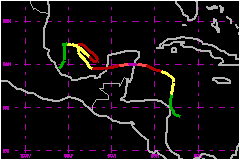
a. Synoptic HistoryRoxanne formed from a complex combination of several synoptic-scale
features (a broad low-pressure area, a tropical wave and an upper trough)
which interacted over the western Caribbean. Formation of tropical cyclones
from this combination has been commonly observed in the western Caribbean
during previous decades, (e.g., 1930, 1940). As early as 6 October, radiosonde data from the western Caribbean
indicated a broad well-established low- to middle-level cyclonic circulation
with cloudiness and showers between the Cayman Islands and Honduras. A
distinct tropical wave, tracked from the coast of Africa on 26 September,
became convectively active over the central Caribbean on 4 October. The
wave reached the western Caribbean early on the 7th and interacted with
the pre-existing area of disturbed weather. A slow-westward moving upper-level
trough was at that time located over the Windward Passage, to the east
of an upper-level anticyclone centered over the southeastern Gulf of Mexico
and left by Hurricane Opal.
This combination of the high and the trough aloft resulted in diffluent
northerly winds over the low-level disturbance. On 6 October, the National Hurricane Center (NHC) surface analysis
showed a broad 1004 mb low not too far from the east coast of Nicaragua.
Associated winds were only 12 to 17 mph. Satellite images indicated a
gradual increase in organization and cloud banding features began to develop
early on the 7th as the tropical wave reached the area. It is estimated
that the system became a tropical depression at 1800 UTC 7 October just
east of Nicaragua. The next day, a reconnaissance plane confirmed the
presence of a tropical depression with a pressure center of 1004 mb and
35 mph winds. Satellite images and surface observations indicated a steady
intensification. The depression became Tropical Storm Roxanne at 0000
UTC 9 October and a hurricane by 0600 on the 10th. During that period,
data from reconnaissance planes indicated that the pressure dropped to
989 mb and by 1200 UTC on the 10th the pressure was down to 972 mb. Prior
to intensification, the low-level center was located on the northern edge
of the deep convection due to the northerly winds produced by the upper
high over the Gulf of Mexico. However, the upper trough previously located
over the Windward Passage became a cut-off low and moved west-southwest
into Central America. This allowed the outflow to become established in
all quadrants. Initially, Roxanne was a threat to Cuba and the Cayman Islands
as it moved northward in response to a weak trough over Florida and the
eastern Gulf of Mexico. The trough moved eastward and was replaced by
a high pressure system. Roxanne turned northwestward and then westward
toward the Yucatan peninsula and intensified. A similar abrupt change
in motion, not expected by climatology, was taken by Hurricane Hattie
in 1961. During the early afternoon of the 10th, a well-defined eye
became apparent on satellite images. Roxanne reached its maximum intensity
of 115 mph and a minimum pressure of 956 mb about
2152 UTC just to the southeast of Cozumel. Roxanne made landfall just north of Tulum, on the mainland,
Mexico just to the southwest of Cozumel about 0200 UTC 11 October. The
hurricane continued westward over the Yucatan peninsula and emerged over
the Gulf of Campeche as a minimal hurricane. It then temporarily weakened
to tropical storm status. Once the center of circulation was completely
over the waters, the tropical cyclone regained hurricane intensity and
maintained that status for about 60 hours. It gradually weakened to a
tropical storm and then to a tropical depression. The steering currents were weak when Roxanne was in the Bay
of Campeche. Consequently, the hurricane meandered within an area of less
than 250 nautical miles for almost a week. During that period, several
shortwave troughs and ridges rapidly passed by to the north of Roxanne,
forcing the tropical cyclone to swing either southeastward or northwestward.
Feeder bands and waves of 15 to 20 feet were pounding the coastal section
from the State of Campeche to Veracruz throughout that time. Eventually,
Roxanne was forced to move southward into the area near Veracruz by an
approaching strong cold front. The remnants of the tropical cyclone moved
southwestward into Mexico. b. Meteorological Statistics
| ||||||||||||||||||||||||
| Date/Time (UTC) |
Position | Pressure (mb) |
Wind Speed (mph) |
Stage | |
|---|---|---|---|---|---|
| Lat. (°N) | Lon. (°W) | ||||
| 10/2152 | 20.0 | 86.7 | 956 | 115 | Category 3 Hurricane |
Landfall for
Hurricane Roxanne
07 - 21 October, 1995
| Date/Time (UTC) |
Pressure (mb) |
Wind Speed (mph) |
Stage | Landfall |
|---|---|---|---|---|
| 11/0200 | 958 | 115 | Category 3 Hurricane | Tolum, Mexico |