|
|
|
|
|||||||||||||||||||||||||||||
|---|---|---|---|---|---|---|---|---|---|---|---|---|---|---|---|---|---|---|---|---|---|---|---|---|---|---|---|---|---|
|
1995 PRELIMINARY
REPORTS |
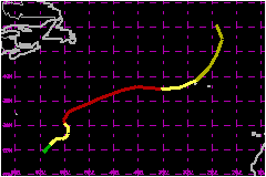
a. Synoptic HistoryTanya originated from a tropical wave that, based on extrapolation,
moved off the west coast of Africa in mid-October. This wave followed
one that spawned Tropical Storm Sebastien, and was not easily
identifiable as a cloud mass on satellite pictures until 20 October, when
it neared 40�W longitude in the tropical Atlantic. The wave moved slowly
westward for a few days. By 24 October, cloudiness associated with the
wave merged with an area of convection to the east and northeast of Tropical Depression Sebastien. This weather
was partly associated with an upper-level cyclone that was producing shearing
winds over Sebastien, causing its demise. At 1800 UTC
on the 25th, a low cloud swirl was evident in the vicinity of 22�N 60�W.
However, this system was barely classifiable by the Dvorak technique since
deep convection was not very close to the center. The low-cloud swirl
became more pronounced on satellite images on the 26th. By 0000 UTC 27
October, surface observations indicated a definite closed surface circulation,
and the tropical depression stage of Tanya is initiated at this time in
the post-analysis best track. The movement of the tropical cyclone was controlled mainly
by two factors: shortwaves in the midlatitude westerlies and the upper-level
cyclone in Tanya's vicinity. Initially the cyclone moved northeastward,
in response to an approaching shortwave trough. However, due to the effect
of the upper cyclone, Tanya turned more eastward and slowed. Because of the influence of the upper-level cyclone, the development
of Tanya was not like that of a typical tropical cyclone in the deep tropics.
On the 27th and 28th, the system had some subtropical characteristics,
i.e. a large comma-shaped cloud band and strongest winds well removed
from the center. Nonetheless, Tanya's winds increased to tropical storm
force by 1200 UTC on the 27th and gradual strengthening continued thereafter.
Convection developed closer to the center by 1800 UTC on the 28th, and
on the following day the cloud pattern was more symmetrical about the
center. Tanya reached hurricane strength around 1200 UTC on the 29th,
when a small eye was observed in the middle of the central dense overcast. While Tanya was strengthening into a hurricane, its motion
was cyclonic along roughly a half-circular path, again due to the adjacent
upper low. This movement continued into the 29th, when a strong eastward-moving
mid-tropospheric trough over the western Atlantic, and associated cold
front near Bermuda, began to influence the track of the hurricane. Tanya
turned north- northeastward on the 30th, and east-northeastward later
that same day. Early on the 31st, while still embedded in a narrow wedge
of warmer air between cooler air masses over the western and eastern Atlantic,
the system acquired peak intensity of 86-mph winds
with a 972 mb central pressure. On the 1st of November, Tanya veered to the east and weakened
to a tropical storm - headed in the general direction of the Azores. As
the storm neared those islands, the movement became more northeasterly,
taking the center just to the north of the Azores. Tanya was becoming
extratropical as it passed near the Azores. The extratropical cyclone
turned north-northeastward, then northward, and was absorbed into a larger
low pressure system over the north Atlantic by 0600 3 November. b. Meteorological Statistics
| ||||||||||||||||||||||||||||
| Date/Time (UTC) |
Position | Pressure (mb) |
Wind Speed (mph) |
Stage | |
|---|---|---|---|---|---|
| Lat. (°N) | Lon. (°W) | ||||
| 31/0600 | 35.4 | 48.3 | 972 | 85 | Category 1 Hurricane |
Minimum
Pressure For Hurricane Tanya
27 October - 03 November, 1995
| Date/Time (UTC) |
Position | Pressure (mb) |
Wind Speed (mph) |
Stage | |
|---|---|---|---|---|---|
| Lat. (°N) | Lon. (°W) | ||||
| 02/0000 | 39.2 | 28.2 | 970 | 65 | Extratropical Storm |