|
|
|
|
|||||||||||||||||||||||||
|---|---|---|---|---|---|---|---|---|---|---|---|---|---|---|---|---|---|---|---|---|---|---|---|---|---|
|
1995 PRELIMINARY
REPORTS |
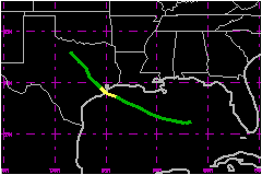
a. Synoptic HistoryTropical Storm Dean developed from a broad quasi-stationary
middle-level trough extending from the northeastern Gulf of Mexico through
Florida. On the 27th of July, a weak cyclonic circulation was indicated
by buoy reports in the eastern Gulf of Mexico accompanied by surface pressure
falls of about 2.5 mb in 24 hours. At that time, satellite images showed
that the thunderstorm activity was disorganized but the upper-level outflow
was beginning to become established. On the 28th, animation of high resolution
visible satellite images clearly showed a low-level cyclonic rotation.
Based on that information and on surface reports, it is estimated that
Tropical Depression Four formed about 300 nautical miles southeast of New Orleans
at 1800 UTC July 28. A reconnaissance plane was dispatched to the area and located
a circulation center of 1008 mb minimum pressure. The maximum flight-level
(1500 ft) wind was 37 mph. The depression moved slowly toward the west
to west-northwest around a well-established mid-level high pressure ridge
located over the central U.S., with no significant change in strength.
The depression was under continuous reconnaissance surveillance and, during
the time between the last fix at 1712 UTC 30 July of mission number 5
and the first fix of mission number 6 at 2142 UTC 30 July, the pressure
dropped from 1005 mb to 999 mb and the flight-level (1500 ft) winds increased
from 46 to 58 mph. Using this data, it is estimated
that the depression became Tropical Storm Dean at 1800 UTC 30 July about
60 nautical miles from the upper Texas coast. The center of Dean crossed the coast
near Freeport, Texas a few hours later. Tropical cyclones have occasionally
intensified just prior to making landfall in that area. Dean weakened to tropical depression status shortly after landfall
and continued on a northwestward track through Texas. The depression became
nearly stationary for about 24 to 36 hours over the northwest portion
of the state producing heavy rainfall. It dissipated at 0000 UTC August
3 as it merged with a frontal zone.
b. Meteorological Statistics There were no reports of tropical storm force winds (1-min
sustained) from surface land stations. The highest observed wind was a
51-mph gust reported by Galveston Scholes Field
at 2115 UTC 30 July.
1. Storm Surge DataThe storm tide rose and covered the road along highway 82
between Johnsons Bayou and Holly Beach in Cameron Parish, Louisiana. Minor
storm surge flooding of highway 87 occurred on the 30th. 2. TornadoesThere were two tornadoes associated with Dean. The first
occurred in Galveston County at High Island around 2330 UTC and the second
touched down just southeast of Anahua near 0300 UTC. c. Casualty and Damage StatisticsThere were no reports of injuries or deaths associated with
Dean. However, rainfall was a problem causing near $500,000
in damage. Evacuation of 20 families was necessary in Chambers County
due to rainfall flooding. Data were provided by local weather service
forecast offices.
Maximum Intensity
For Tropical Storm Dean
Landfall for
Tropical Storm Dean
| ||||||||||||||||||||||||