|
|
|
|
||||||||||||||||||||||||||||||||||||||||||||
|---|---|---|---|---|---|---|---|---|---|---|---|---|---|---|---|---|---|---|---|---|---|---|---|---|---|---|---|---|---|---|---|---|---|---|---|---|---|---|---|---|---|---|---|---|
|
1995 PRELIMINARY
REPORTS |
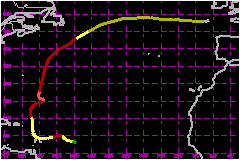
a. Synoptic HistoryThe wave associated with the formation of Iris crossed the
coast of Africa and began moving over the Atlantic Ocean on August 16th.
Surface analyses showed a closed circulation around a 1009 mb pressure
center located just south of Dakar. A day later, the circulation was evident
in surface observations and satellite pictures near the Cape Verde Islands.
Associated deep convection diminished on the 18th and 19th, but then gradually
redeveloped. Dvorak technique T-numbers of 1.0 were assigned by the NHC
Tropical Analysis and Forecast Branch (TAFB; TSAF in figures) on the 21st
and both the TAFB and NESDIS Synoptic Analysis Branch indicated T-2.0
on the 22nd. From the satellite data it is estimated that the system became
the 10th Atlantic tropical depression of the season at 1200 UTC on the
22nd, when located about 600 nautical miles to the east of the Lesser
Antilles. It became Tropical Storm Iris six hours later. The cyclone took a jog to the northwest on the 23rd and quickly
strengthened. The first reconnaissance flight into Iris took place that
evening and found the system to be stronger than operational estimates
based on satellite pictures. The aircraft encountered 106
mph 10-second winds at a flight level of about 500 m, and a central
pressure of 991 mb was reported. From this data, Iris is analyzed as a
hurricane at 1800 UTC on the 23rd. Iris moved toward the west-southwest at about 12 mph on the
24th and 25th. The change in heading was probably a consequence of a Fujiwhara
interaction between Iris and Humberto located about 750 nautical miles
to the east--Humberto had developed from a depression
on the 22nd to a 109-mph hurricane by late on the 24th. On the 25th, Iris neared the Lesser Antilles. An upper-level
cold low was centered then to the north of Puerto Rico. Westerly vertical
wind shear occurred, separating deep convection from the low-level cloud
center, disrupting the circulation, and slowing the general westward progress
of the cyclone. Iris weakened back to tropical storm strength. Reconnaissance
aircraft and radar data indicate a reformation of the center to the east
of the former position while the system meandered for about a day before
moving into the islands. Steering currents ahead of a trough to the northwest then turned
Iris generally toward the north-northwest on the 27th. On this track,
Iris moved up the chain of Leeward Islands and strengthened as the shear
decreased. Late on the 28th, Iris regained hurricane status over the south-central
Atlantic. Iris began a Fujiwhara interaction on the 30th, with Tropical
Storm Karen to its southeast. The interaction swept the weaker Karen on a spiral path around, and then into,
Iris where it was absorbed on September 3rd. The interaction could have
contributed to Iris' erratic motion during this period. An eye appeared intermittently and the intensity of Iris fluctuated
from August 29th through September 2nd. Iris reached its peak intensity
of 109 mph several hundred miles to the southeast of Bermuda
on the 1st. Iris then weakened, temporarily, in an environment of shear
and relatively cool water. It dropped below hurricane strength and became
extratropical while accelerating northeastward well to the southeast of
Newfoundland on the 4th. It then turned eastward and deepened. The pressure
fell from around 1000 mb to near 957 mb in about 48 hours. On the 7th,
Iris battered western Europe as a powerful extratropical storm with sustained
wind speeds near 75 mph.
b. Meteorological Statistics The ship Pallas Athena reported 39-46 mph winds at 1200 UTC on September 1 while located
about 100 nautical miles to the south-southeast of the center of Iris.
This was the only ship report of wind speeds 39 mph or greater received
by the NHC for the tropical cyclone phase of Iris. The only available observation of sustained tropical storm
force winds in Caribbean islands came from Desirade (just east of Guadeloupe)
where a 52 mph (2-min) wind and 62 mph gust occurred.
Highest reported gusts elsewhere reached 56 mph at Martinique, 46 mph
at Antigua, 43 mph at Dominica, and 41
mph at St. Kitts. The lowest pressure reported from the northeastern
Caribbean area was 999 mb at Antigua. 1. Rainfall DataThe primary meteorological event caused by Iris in the Caribbean islands was heavy rain. The totals were particularly large in Martinique where Ducos (La Manzo) had 17.72 inches for the event, with 16.18 inches falling in 24 hours. Other peak rainfall rates in Martinique included 1.89 inches in 30 minutes, 3.01 inches in 1 hour and 4.61 inches in 2 hours at Trois Ilets, Vauclin, and Ducos, respectively. An average of 6 inches of rain fell on Antigua.
c. Casualty and Damage StatisticsThere were 5 deaths attributed to Iris; 4 in Martinique and
1 in Guadeloupe. Few damage reports have been received at the NHC. There was extensive flooding in low-lying areas and destruction of banana trees on Antigua. Similar damage likely occurred on neighboring islands.
Maximum
Sustained Winds For Hurricane Iris
Minimum
Pressure For Hurricane Iris
Landfall
for Hurricane Iris
| |||||||||||||||||||||||||||||||||||||||||||