|
|
|
|
|||||||||||||||
|---|---|---|---|---|---|---|---|---|---|---|---|---|---|---|---|
|
1996 PRELIMINARY
REPORTS |
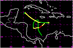
Hurricane Marco drifted aimlessly over the western Caribbean Sea for about a week threatening several land areas but never making landfall. a. Synoptic HistoryA cold front moved into the northwestern Caribbean on 9 November,
followed by an abnormally strong high pressure system which dominated
the eastern United States. The front became nearly stationary and interacted
with a series of westward moving tropical waves. The Intertropical Convergence
Zone (ITCZ) became active in the southwestern Caribbean as monsoonal southwesterly
flow from the eastern Pacific reached the area. As early as 13 November,
surface analysis showed a weak low pressure area just north of Colombia
and, by the next day, there was a well-defined but broad low-level circulation
between Jamaica and Honduras. At that time, the system did not meet the
criteria for tropical depression status because the convection was not
concentrated nor organized near a center of circulation. In fact, there
were several smaller centers of circulation embedded within a much larger
system. The broad area of low pressure drifted northward for a couple
of days, and in combination with a high pressure system over the United
States, produced gale force winds over Florida, Cuba, the Bahamas and
the Gulf of Mexico. The convection gradually became organized south of Jamaica
and a post-analysis of the surface and reconnaissance aircraft data indicates
that the system became a tropical depression at 1800 UTC November 16.
The poorly-defined tropical depression moved generally southward and encountered
a much better upper-level environment for strengthening. It became a tropical
storm at 0600 UTC 19 November and then moved on a slow east-northeast
track. Marco briefly reached hurricane status at 0600 UTC 20 November
with maximum winds of 75 mph and a minimum pressure of 983 mb. Thereafter,
Marco was hit by strong upper-level westerlies and weakened rapidly to
a tropical depression at 1800 UTC 23 November. It was then located just
to the southeast of Jamaica. Once a middle-level ridge rebuilt over the Bahamas and Florida,
Marco turned toward the west and west-northwest and regained tropical
storm strength. The tropical cyclone was south of the western tip of Cuba
when it interacted with a cold front and dissipated by 1800 UTC 26 November.
The remnants of Marco drifted southward and produced heavy rains over
Honduras and Belize. Marco was characterized by its numerous intensity fluctuations.
For several consecutive days, Marco became disorganized during the afternoon
when the low-level center was practically exposed and there was an increase
in the central pressure. This was followed by a significant redevelopment
of the convection and a drop in pressure during the nights and early mornings.
These fluctuations could be attributed to the interaction of Marco with
a series of fast moving shortwave troughs and ridges observed on water
vapor imagery. These features increased and relaxed the shear while moving
through the area. b. Meteorological StatisticsMarco was upgraded to a hurricane based on a 72-mph 1-min
sustained wind reported by a U.S. Navy ship. Shortly thereafter. A reconnaissance
plane reported a minimum pressure of 983 mb and 1-sec wind of 102 mph.
This was a significant pressure drop of 11 mb in 1 h and 40 minutes. During
that flight, the crew reported a volatile center structure with severe
turbulence, extreme rainfall and hail. Satellite images showed very cold
convective tops at that time. During the early morning flight of 22 November,
the reconnaissance plane observed another pressure drop from 996 to 985
mb in about 2 hours, and a 5 nautical mile diameter eye. The vessel PFAS
reported sustained winds of 64 mph and a pressure of 1007.5 mb at 1200
UTC 25 November. This observation was used to operationally upgrade Marco
to a tropical storm for the second time. c. Casualty and Damage StatisticsThere were 8 deaths attributed to Marco.
Minimum Pressure For Hurricane Marco
| ||||||||||||||