|
|
|
|
|||||||||||||||||||||||||
|---|---|---|---|---|---|---|---|---|---|---|---|---|---|---|---|---|---|---|---|---|---|---|---|---|---|
|
1989 PRELIMINARY
REPORTS |
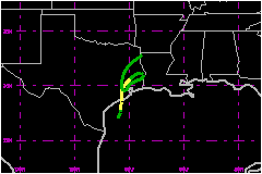
Tropical Storm Allison, although never reaching hurricane strength, proved to be a very destructive event. Allison caused $500 Million in damages during a six day period due mainly to the flooding from the torrential rains that fell along the upper Texas coast and over the western two thirds of Louisiana. The looping storm, which produced over 29 inches of rain in a few areas of central Louisiana will long be remembered as one of the wettest ever for the state of Louisiana. a. Synoptic HistoryThe formation of Tropical Storm Allison can be attributed to at least 3 meteorological phenomena: the remnants of the east Pacific Hurricane Cosme, the northern portion of a westward moving tropical wave and a strong anticyclone at 200 millibars over the Gulf of Mexico. These three factors in addition to a building ridge of high pressure over the central plains provided the environment that created Allison. A strong mid to upper level trough in th westerlies which turned Cosme to the north and spread the remnants of that storm over northern Mexico and the western Gulf of Mexico had been replaced by a large well defined 200 millibar anticyclone that covered the entire Gulf of Mexico. To the north, moderate to strong ridging occured on 22 through 24 June, and during this time the northern portion of tropical wave number eight had moved into the western Gulf of Mexico Heavy thunderstorms began to develop over the Gulf of Mexico on 22 June and by 23 June the activity became concentrated over the northwest portion of the Gulf. Data from upper air soundings indicated that the circulation from the remnants of Cosme were just to the southwest of Brownsville, Texas, at 1200 UTC on 23 June. During the following 24 hours, a new broad weak surface circulation developed just off the upper Mexican coast. Based upon surface observation along the coast and data from offshore oil rigs, the area of disturbed weather was upgraded to Tropical Depression Two at 1800 UTC on 24 June. The depression gradually became better organized during the next 2 days. Early on the morning of 26 June, Air Force reconnaissance aircraft detected a large area of 46 to 52 mph winds at a flight level of 1500 feet; and the depression was officially upgraded to Tropical Storm Allison at 1200 UTC 26 June. However, post analysis indicated the depression probably reached tropical storm strength near 0000 UTC on 26 June. At 0100 UTC on 26 June the ship M/T Jacinth (LAOE2), located about 100 nautical miles northeast of the estimated center of the storm, reported east southeast winds of 40 mph with gusts to 52 mph. By 1200 UTC 26 June a frontal trough in the westerlies moving
across the western United States began to erode the ridge of high pressure
to the north of Allison, and the storm began to accelerate toward the
north in advance of the trough. The center of Allison moved inland on
the middle Texas coast near the northeast end of Matagorda Bay at 1300
UTC 26 June with a central pressure of 1002 millibars. The central pressure
of the storm continued to decrease and reached an estimated minimum reading
of 999 millibars at 0100 UTC 27 June while the center of Allison was located
just to the west northwest of Houston, Texas. Thereafter, the storm began
to weaken, was downgraded to a tropical depression by 1200 UTC 27 June,
and became an extratropical low pressure center by 0000 UTC 28 June. b. Meteorological StatisticsWind gusts to to tropical storm force occured in the clusters
of heavy showers and thunderstorms as early as 24 June. Practically all
of the strongest surface winds and peak gusts measured in Allison occured
in the clusters of heavy thunderstorms that developed in the right half
of the tropical cyclone's circulation. Satellite pictures the heavy thunderstorm
activity that had developed by 26 and 27 June. Strongest winds and peak
gusts from the offshore oil rigs occurred as these heavy thunderstorms
crossed over the observation platforms. Note: The oil rigs L40 and 01T
measured maximum sustained winds of 58 to 46 mph, respectively, on 26
June while in heavy precipitation. Also the coastal observation site 7R5
recorded a peak gust of 69 mph in a thunderstorm. 1. Rainfall Data Torrential rains accompanying Allison fell along the upper
Texas coast and over the western two thirds of Louisiana. Nearly 30 inches
(29.52) fell in a six day period at a few locations in north central Louisiana
and amounts of 10 to 15 inches were common along the upper Texas coast.
The small community of Winfield, Louisiana, had 29.52 inches of rain from
26 June through 01 July, with 17 inches falling in a three day period.
Portions of Harris County, Texas, received over 18 inches. c. Casualty and Damage StatisticsThere were 11 deaths attributed to Allison; 5 in Mississippi,
3 in Louisiana and 3 in Texas. Damage from Allison is estimated at $500 Million. Almost all damage occured from the flooding producd by the heavy rains. Estimates include $200 Million to $400 Million in damages in Texas while upwards of $100 Million was reported in Louisiana. Mississippi claimed nearly $60 Million in damages.
Maximum Intensity For Tropical
Storm Allison
Landfall for Tropical
Storm Allison
| ||||||||||||||||||||||||