HURRICANE GABRIELLE 1989

Hurricane Gabrielle 1989

Preliminary Report
Hurricane Gabrielle
30 August - 13 September 1989


1989 PRELIMINARY REPORTS

Tropical Storm Allison (TS)
Tropical Storm Barry (TS)
Hurricane Chantal (1)
Hurricane Dean (2)
Hurricane Erin (2)
Hurricane Felix (1)
Hurricane Gabrielle (4)
Hurricane Hugo (5)
Tropical Storm Iris (TS)
Hurricane Jerry (1)
Tropical Storm Karen (TS)


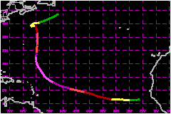
Hurricane Gabrielle was a classic Cape Verde type tropical cyclone. It developed from an African wave near the Cape Verde Islands, tracked westward across the tropical Atlantic while strengthening to a large category four hurricane on the Saffir/Simpson Hurricane Scale and made the typical parabloic recurvature into the northern North Atlantic.


a. Synoptic History

The tropical which became Gabrielle moved off the coast of Africa on 28 August immediately following the wave which developed into Felix. However the wave associated with Gabrielle was located further to the south than Felix and tracked westward. The wave was well organized with a moderate amount of convection and didn't take long to develop into the 10th tropical depression of the season. Based upon two ship reports at 1200 UTC 30 August (UQYC located near latitude 14.3°N, longitude 20.9°W with the northeast winds of 35 mph in showers and UJTG located near latitude 8.7°N, longitude 22.7°W with southwest winds of 17 mph), the wave likely became a tropical depression near 1200 UTC on 30 August.

Even though Tropical Depression Ten was located within 1000 miles to the southeast of Tropical Storm Felix, the depression tracked toward the west as high pressure ridging from the northeast built a wedge between the two systems.

A distinct outflow pattern at the 200 millibar level provided ventilation for the budding storm and, based upon satellite imagery from the European Meteosat, the depression was upgraded to Tropical Storm Gabrielle at 0000 UTC 31 August. By 1200 UTC the storm had already become rather large and well developed. A ship of unknown identity located about 180 nautical miles south of the storm reported 40 mph winds with a pressure of 1008 while the upper air sounding from Sal in the Cape Verde Islands located about 450 nautical miles to the northeast of Gabrielle's center reported east southeast winds of 58 mph at the 700 millibar level.

Gabrielle tracked toward the west northwest for the next several days and strengthened to a category four by 3 September. Meanwhile, the ridge of high pressure which had built westward to the north of Gabrielle continued to form a wedge of high pressure between Gabrielle and Felix. By 0000 UTC 4 September a major trough extended from just east of the Canadian Maritimes southwestward to the Georgia-Florida border. By 0600 UTC 5 September a wave developed on the surface trough which created pressure falls to the northwest of Gabrielle and the hurricane turned to the northwest in response to a change in the steering flow associated with the weakness. Gabrielle passed to the northeast to the northeastern Caribbean Islands. During this same period of time Felix, located about 1000 miles to the north northeast began to strengthen to hurricane force. Felix's strengthening weakened the high pressure between the two hurricanes and Gabrielle turned toward the the north.

Gabrielle continued moving toward the north for the next several days in response to a very broad north-south oriented trough which covered most of the Western North Atlantic. By 10 September Gabrielle became nearly stationary about 475 nautical miles east southeast of of Cape Code, Massachusetts. Located in the center of a broad trough with the westerly jet stream well to the north, the weakening hurricane drifted slowly westward and weakened to tropical storm strength on the 10th and to a depression on the 11th.

On 12 September another frontal trough moving off the north eastern U.S. coast turned Gabrielle toward the northeast. By 13 September the depression lost most of its tropical characteristics as it merged with a developing North Atlantic storm off Newfoundland.


b. Meteorological Statistics

Based upon satellite imagery, Gabrielle had strengthened to 960 millibars with estimated winds of 117 mph by 1800 UTC 3 September. The first reconnaissance aircraft arrived in the hurricane at 1820 UTC and found a central pressure of 937 millibars by exploration from a flight level of 1500 feet. Shortly thereafter, at 2046 UTC, the NOAA reconnaissance aircraft determined the hurricane's minimum pressure to be 935 millibars by exploration from the 700 millibar level. Strongest winds measured by the NOAA aircraft at this time were 121 mph. 0525 UTC on 4 September the central pressure rose to 940 millibars and strongest winds remained near 121 mph. The next reconnaissance plane into the hurricane on the afternoon of 4 September measured central pressures of 942 to 944 millibars and strongest 700 millibar flight level winds of 152 mph. Maximum flight level winds measured in the hurricane were 160 mph at the 700 millibar level at 2258 UTC 5 September with a central pressure of 943 millibars.

An examination of the data suggests that the strongest winds in Hurricane Gabrielle did not occur simultaneously with the lowest central pressure. The reasoning for this is not fully understood. The NOAA reconnaissance aircraft may not have flown into the areas of maximum winds when the central pressure was 935 millibars, or due to the concentric banding that was occuring during this period the pressure grandient may not have been as strong as the gradient that developed the following day. Since rapid intensification seemed to occur during the 12 hours prior to the plane's arrival, it is possible that the wind field had not had time to adjust to the rapidly changing pressure gradient.

Gabrielle was a very large hurricane. The eye diameter never decreased to less than 20 nautical miles and the majority of the time while the hurricane was most intense the eye diameter ranged from 40 to 50 nautical miles. Hurricane force winds frequently extended outwards from the hurricane's center in excess of 100 nautical miles and 115 mph winds at flight level occasionally extended outward to near 100 nautical miles. Gabrielle's powerful winds covered a very large area of the ocean and generated large ocean swells which pounded the shores of the northeastern Caribbean islands as well as Bermuda and the North American mainland from central Florida to the Canadian Maritimes.


1. Storm Surge Data

Swells ranged from 10 to 15 feet along portions of the U.S. east coast and were as high as 20 to 30 feet along the south coast of Nova Scotia.


c. Casualty and Damage Statistics

There were 8 deaths attributed to Gabrielle; 4 in New York, 2 in Massachusetts, 1 in New Jersey and 1 in Maine.

The large swells from Hurricane Gabrielle were responsible for deaths along the mid-Atlantic and New England coasts. Accidents, ranging from people being swept from jetties while watching the large swells to boats capsizing while trying to enter or leave inlets, claimed a total of 8 lives. Deaths included 2 in Massachusetts, 4 in New York, 1 in Maine and 1 in New Jersey.


Maximum Sustained Winds For Hurricane Gabrielle
30 August - 13 September, 1989

Date/Time
(UTC)
Position Pressure
(mb)
Wind Speed
(mph)
Stage
Lat. (°N) Lon. (°W)
03/2046 16.8 50.9 935 105 Category 2 Hurricane


Minimum Pressure For Hurricane Gabrielle
30 August - 13 September, 1989

Date/Time
(UTC)
Position Pressure
(mb)
Wind Speed
(mph)
Stage
Lat. (°N) Lon. (°W)
05/1800 21.4 57.8 941 145 Category 4 Hurricane