1989 PRELIMINARY
REPORTS
Tropical
Storm Allison (TS)
Tropical Storm Barry (TS)
Hurricane Chantal (1)
Hurricane Dean (2)
Hurricane Erin (2)
Hurricane Felix (1)
Hurricane Gabrielle (4)
Hurricane Hugo (5)
Tropical Storm Iris (TS)
Hurricane Jerry (1)
Tropical Storm Karen (TS)
|
Hurricane Chantal was the first hurricane of the 1989 Atlantic Season.
Although Chantal was not a strong hurricane, it thoroughly tested preparedness
efforts along the upper Texas coast while making landfall near High
Island, Texas, between Galveston and Sea Rim State Park, on 1 August
1989.
a. Synoptic History
The system that provided the embryo for Chantal could not be
traced back to Africa as a tropical wave, but first appeared on 24 July
as an ITCZ disturbance near Trinidad just off the coast of South America.
The system moved westward across the Caribbean with little development
until approaching Honduras on the 27th. Beginning on the 27th, NHC highlighted
the the wave in the Tropical Weather Discussions (TWD), the Satellite
Interpretation Messages (SIM), and in the Tropical Weather Outlooks (TWO).
Even though the outflow was impressive on satellite imagery on the 27th,
there was some uncertainty about the potential for development due to
close proximity to land. Thus, the TWO's indicated that development if
any would be slow.
By 1800 UTC on the 28th, synoptic reports indicated the possibility
of a surface low near Belize City. However, during the next 24 hours the
system was disorganized while over the Yucatan Peninsula. Beginning at
0230 UTC on the 30th, NHC indicated in the TWO's that there was some potential
for development as the system was in the process of emerging off the coast
near Merida, Mexico.
Satellite pictures at 0900 UTC on the 30th indicated that although
the center was still close to the Yucatan Peninsula, the cloud pattern
was becoming better organized. Ship data and satellite imagery confirmed
that a tropical depression had formed and the first advisory on Tropical
Depression Four was issued at 1900 UTC on the 30th. After the fact, it
is estimated that the tropical depression likely formed in the south central
Gulf of Mexico about 80 nautical miles north of the Yucatan Peninsula
as early as 1200 UTC on the 30th.
Based on estimates by satellite analysts using the Dvorak technique,
Tropical Storm Chantal likely formed 310 nautical miles southeast of Galveston,
Texas at 0600 UTC on the 31st. However, interpretation of infrared satellite
imagery during the night can be misleading and the NHC decided to wait
for reconnaissance confirmation before formally upgrading the system.
When the first Air Force reconnaissance plane arrived in the system at
1224 UTC on the 31st, the pressure was already down to 994 mb and the
estimated surface winds were 52 mph. Ship HZZB located 150 nautical
miles east northeast of the center reported 58 mph winds at 1200 UTC.
NHC issued a special advisory at 1300 UTC on the 31st upgrading the depression
to a tropical storm. Outflow conditions favoured continued strengthening
and hurricane warnings were issued at that time from Freeport, Texas to
Morgan City, Louisiana based on the anticipated motion of the center.
Normally the rate of development of a tropical system is one T number
per day using the Dvorak technique. NHC satellite meteorologists classified
the system as a T 1.5 at 1800 UTC on the 30th, a 2.5 at 0600 UTC on the
31st, and a 3.5 at 1800 UTC on the 31st. Thus the rate of development
during that 24 hour period was two T numbers per day which is rapid.
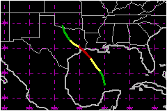
Strengthening Tropical Storm Chantal moved toward the northwest at 12
mph in responce to weak ridging extending westward across Florida. During
the afternoon of the 31st, an Air Force reconnaissance plane found 91
mph winds at 1500 feet and satellite pictures were showing better organization.
Thus Chantal was formally upgraded to hurricane at 2200 UTC.
Hurricane Chantal passed between oil rigs T81 and WC 459A, between W76
and P95, and to the west of P12 on its trek toward the upper Texas coast.
At 0439 UTC on the 1st, WC 459A reported sustained winds of 70 mph with
gusts to 79 mph at an elevation of 80 feet and a surface pressure of 994
mb. The hurricane was under continuous surveillance by both the Galveston
and the Lake Charles radars when within about 100 nautical miles of the
coast. Small scale fluctuations were noted in the radar positions but
generally they were within about 10 nautical miles of the best track.
Chantal continued strengthening while approaching the Texas coast and
at 1050 UTC reconnaissance reports were showing flight level winds of
94 mph at 850 millibars and the minimum pressure extrapolated to the surface
was 984 mb. At 1156 UTC, about one hour prior to landfall, the pressure
was 986 mb. Thus, Chantal reached its peak intensity just prior to the
center making landfall at High Island, Texas near 1300 UTC as a Category
1 hurricane on the Saffir/Simpson Hurricane Scale.
The center of Chantal continued moving northwestward passing close to
Dayton, Conroe, just northeast of College Station, and just east of Waco
before turning north northwestward to just west of Cleburne and east of
Mineral Wells before dissipating in southwestern Oklahoma by 0600 UTC
on 3 August 1989. Although the system could not be tracked at the surface
beyond then, satellite pictures showed that the cloud shield traveled
to eastern Kansas, eastern Iowa, Michigan, New York, and eventually joined
cloudiness associated with a trough over New England. That combined cloudiness
passed over Newfoundland early on 7 August ahead of Hurricane
Dean.
b. Meteorological Statistics
The center of Hurricane Chantal crossed the upper Texas coast
at High Island near 1300 UTC on 01 August with sustained winds estimated
at 81 mph and a minimum pressure of 986 mb. The highest winds reported
at a costal location were at Galveston where a sustained wind of 69 mph
and a gust of 82 mph were observed. The highest sustained wind at Sea
Rim State park was 54 mph with a gust to 62 mph. Sea Rim State Park had
about 7 continuous hours with sustained winds of tropical storm force.
The minimum pressure at Sea Rim State Park occurred at 1200 UTC, about
one hour prior to landfall, when the surface winds were from the east
southeast. At 1300 UTC, the wind was from the south southeast and the
pressure was 2.3 mb higher. The lowest pressure reported at a land station
was 994 mb at Houston Intercontinental Airport at 1700 UTC.
1. Storm Surge Data
Tides at High Island were 7 feet MSL. Kemah reported 3.8
feet MSL and Galveston Flagship Pier had 3.5 feet MSL. Tides at Sabine
Pass were 4 feet MSL. There was extensive beach erosion from High Island
to Sea Rim State Park.
2. Rainfall Data
Rainfall associated with Chantal varied considerably. Houston's
Hobby Airport reported 7.14 inches in 6 hours and 8.58 inches in 24 hours,
whereas Houston International Airport had only 1.21 inches in 6 hours
and 2.05 inches in 24 hours. Unofficially, Friendwood, southeast of Hobby
had a storm total of 20 inches and Clear Lake, northeast of Alvin, had
16 inches.
3. Tornadoes
One confirmed torando was reported on Crystal Beach (Galveston
County) causing total destruction to a boat shed. A tornado touched down
near Iota, LA uprooting several trees and moving a mobile home off its
foundation.
c. Casualty and Damage Statistics
There were 13 deaths attributed to Chantal; 2 in Texas and
11 in Louisiana.
The main effects from Chantal were from flooding by torrential rains and
beach erosion. Wind effects were relatively light. However, numerous trees,
powerlines, fences and signs were blown down. There was some roof damage
to homes, carports and mobile homes. About 3000 homes in Texas had either
water or wind damage. Total damage is estimated to be near $100
Million.
Thirteen deaths are attributed to Chantal. Two teenage boys
drowned in College Station (Brazos County) when their raft on which they
were riding capsized in flood waters and they were swept into a drainage
pipe. Two others on the raft managed to make it to safety. A 48 year old
man drowned about 100 miles south of New Orleans as he attempted to leave
an oil rig. A 74 foot "lift boat" , Avco 5, capsized in the
Gulf about 20 nautical miles off the coast south of Morgan City, Louisiana.
Four men were rescued about 10 others were trapped in the oil service
vessel, of which 7 are known drowned and three are missing and presumed
drowned. (According to: The Times Picayune, "a lift boat is equipped
with three extendable legs allowing it to work in up to 65 feet of water.
When a crew reaches a work site, the legs are lowered to the sea floor
and the vessel's hull is jacked up above above the waves to provide a
steady platform for pipeline construction and maintenance chores. The
Avco 5 overturned while heading for Safety") There were 18 persons
rescued by U.S. Coast Guard helicopters and rescue boats. Most of these
were fishermen whose boats capsized near the Bolivar Peninsula. Several
of the rescued were near the jetties at Sabine Pass. A man was injured
while evacuating a dredge barge in the coastal waters south of Lafayette,
Louisiana. Hundreds of persons were evacuated by airboats and high water
vehicles in flooded areas in Texas.
Maximum Intensity For Hurricane
Chantal
30 July - 03 August, 1989
Date/Time
(UTC) |
Position |
Pressure
(mb) |
Wind Speed
(mph) |
Stage |
| Lat. (°N) |
Lon. (°W) |
| 01/1000 |
29.2 |
94.0 |
984 |
80 |
Category 1 Hurricane |
Landfall for Hurricane
Chantal
30 July - 03 August, 1989
Date/Time
(UTC) |
Pressure
(mb) |
Wind Speed
(mph) |
Stage |
Landfall |
| 01/1300 |
986 |
80 |
Category 1 Hurricane |
High Island,
Texas |
|