|
|
|
|
|||||||||||||||
|---|---|---|---|---|---|---|---|---|---|---|---|---|---|---|---|
|
1989 PRELIMINARY
REPORTS |
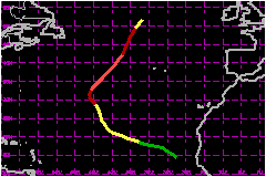
a. Synoptic HistoryA well organized tropical wave was observed on METEOSAT imagery to emerge from the African coast about mid day on 16 August. Once over the cool waters of the eastern Atlantic, the extensive convective activity associated with the system over Africa diminished, leaving a well organized, but small, low level circulation center. Slowly the tropical wave regained its convective activity so that by 0000 UTC 18 August, the system became a tropical depression based upon Dvorak satellite classifications near the Cape Verde Islands. At the same time another well organized, larger scale tropical wave was located in the tropical mid Atlantic and was moving westward. The interaction between this wave and the developing depression caused the system to move north northwestward. This course was maintained for almost 3 days as the depression appeared to be steered by the larger scale tropical wave ahead of it and the eastern portion of the subtropical ridge to the north. Based on analysis of satellite imagery using the Dvorak technique, at 1800 UTC 19 August, the depression was upgraded to Tropical Storm Erin. The storm was then near 18.5°N 32.7°W or about 420 nautical miles west of the northwesternmost Cape Verde Islands. About 1200 nautical miles to the northwest of the tropical storm, the southern portion of an upper level trough began to cutoff near 27°N 45°W. As this practically stationary low pressure system began to grow in size and intensity, it also began working its way down to mid levels. The upper level low controlled Erin with respect to track and intensity for the next 4 days. Initially, as erin approached the upper level low from the southeast, it was adversely affected by strong upper level soutwesterly flow. By 21 August Erin began moving more north northwest as the system was near enough to be steered by the level low. As Erin moved northward into the northeast quadrant of the upper level low, the flow aloft became weaker and more divergent. In this environment Erin strengthened in 24 hours from a 52 mph storm to a hurricane by 1200 UTC 22 August. Now northeast of the upper level low's center, Erin slowed
and began a more northwestward course. This motion was short lived as
a short wave trough moving eastward from the northwest began affecting
the track of the hurricane. By 23 August Erin's course returned to north
and then north northeast as the hurricane's forward speed began to increase.
Erin weakened to tropical storm strength by 0600 UTC 27 August and shortly
afterwards became extratropical. b. Meteorological StatisticsFigures 2 and 3 show the best track wind and pressure curves
as a function of time, along with the observations on which they are based.
All of the observations used in these figures are based on satellite data,
except for the single ship observation which was the basis for upgrading
Erin to hurricane status. It was at 1200 UTC 22 August that Portuguese
ship Montemuro (CSDN) reported a west wind of 75 mph just to the
south of Erin's center. Although the surface pressure observation accompanying
the 75 mph wind was 1003 mb, the same report stated a 13 millibar rise
had occured during the previous 3 hours. Before this observation and for
some time after it, the Dvorak technique as used by analysts at 3 independent
locations did not imply wind speeds of hurricane force. c. Casualty and Damage StatisticsAlthough the tropical depression that spawned Erin passed through the Cape Verde Islands during 18 August, only thunderstorms and gusty winds were observed. There were no reports of casulties or damage reported to the National Hurricane Center related to Erin.
Maximum
Intensity For Hurricane Erin
| ||||||||||||||