|
|
|
|
|||||||||||||||||||||||||||||||||||||||||||||
|---|---|---|---|---|---|---|---|---|---|---|---|---|---|---|---|---|---|---|---|---|---|---|---|---|---|---|---|---|---|---|---|---|---|---|---|---|---|---|---|---|---|---|---|---|---|
|
1989 PRELIMINARY
REPORTS |
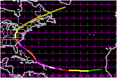
Hugo was a classical Cape Verde hurricane that left a path of devastation across the Leeward Islands, the Virgin Islands, Puerto Rico, and South and North Carolina. a. Synoptic HistoryThe origin of Hugo was detected on satellite imagery on 9 September when a cluster of thunderstorms moved off the coast of Africa and the official best track begins on the 10th when a tropical depression formed to the southeast of the Cape Verde Islands. Hugo moved westward at 21 mph across the tropical Atlantic Ocean, becoming a tropical storm on the 11th and a hurricane on the 13th while located about 1100 nautical miles east of the Leeward Islands. Hugo gradually turned toward the west northwest and slowed its forward speed as it headed for the Leeward Islands in response to low pressure to the north of Puerto Rico which represented a weakness in the westward extension of the subtropical high pressure ridge. Hugo's eye was over Guadeloupe at 0500 UTC on the 17th, as indicated by the landfall information. Continuing to deaccelerate and turning toward the northwest, the eye moved over St. Croix at 0600 UTC on the 18th with a forward speed of nine mph. The hurricane then began to accelerate its forward speed and the eye moved over the island of Vieques, Puerto Rico at 1200 UTC and then over the extreme eastern tip of mainland Puerto Rico at 1300 UTC on the 18th. Early on the 19th, the hurricane was north of Puerto Rico and
moving toward the north-northwest at 14 mph. By this time, the weakness
in the subtropical high pressure ridge had diminished and the hurricane's
motion was under the influence of the ridge and of an upper-level low
pressure system centered over georgia. Hugo's track curved gently to the
northwest over the next few days as the low pressure center moved southwestward
and altered the steering flow pattern. By the 21st, Hugo was centered
a few hundred miles east of Florida and began a gradual turn and acceleration
toward the north in response to the steering flow associated with a major
extratropical low that was advancing eastward across the central U.S. b. Meteorological StatisticsBoth Air Force and NOAA aircraft participated in the reconnaissance
of this hurricane. The first aircraft reached the hurricane on the 15th,
several hundred miles east of the Leeward Islands and reported a central
pressure of 918 millibars, a wind speed of 190 mph at an altitude of 1500
feet and a surface wind speed of 160 mph. This turned out to be Hugo's
maximum intensity. During the following seven days, there were 76 aircraft
penetrations of the eye of the hurricane, for an average of one center
fix every 2 hours. 1. Rainfall Data Rainfall totals ranged up to 9.20 inches at Gurabao in the
eastern interior of Puerto Rico. Rainfall totoals along the southeast
US coast ranged from a trace at Jacksonville to 6.10 inches at Savannah
to a maximum of 8.10 inches at Mt. Pleasant near Charleston to 2.30 inches
at Myrtle Beach to 0.58 inches at Hatteras. A 150 mile wide swath of 3
to 8 inches of rain spread inland across South Carolina. The swath continued
over Western North Carolina with a maximum of 6.91 inches rported at Boone.
Rainfall totals were in the two to four inch range across western Virginia,
West Virginia, western Pennsylvania, eastern Ohio and western New York. c. Casualty and Damage StatisticsThere were 49 deaths attributed to Hugo; 13 in South Carolina, 10 in Monserrat, 11 in Guadeloupe, 6 in Virginia, 3 in U.S. Virgin Islands, 2 in Puerto Rico, 1 in St Kitts and Nevis, 1 in Antigua and Barbuda, 1 in North Carolina. and 1 in New York. Damage Figures are astronomical and Hugo is the costliest hurricane
in U.S. history. The American Insurance Association reports $3.042
Billion as the preliminary estimate of insured property dmaage
for the U.S. mainland, and $500 Million for
Puerto Rico and the U.S. Virgin Islands and these numbers are subject
to upward revision. "The State" newspaper, Columbia, South Carolina,
reports a dollar damage estimate totalling $7.071
Billion for the U.S. mainland, $1 Billion
for Puerto Rico the the U.S. Virgin Islands and another $450
Million for other islands in the Caribbean, including Antigua and
Barbuda, the British Virgin Islands, Guadeloupe, Monserrat and St. Kitts
and Nevis. Hurricane damage estimates for past storms have often been
two to three times the insured property damage and it is possible that
Hugo's international damage total will exceed $10
Billion.
Maximum Intensity For Hurricane
Hugo
Landfall for Hurricane
Hugo
| ||||||||||||||||||||||||||||||||||||||||||||