|
|
|
|
|||||||||||||||||||||||||
|---|---|---|---|---|---|---|---|---|---|---|---|---|---|---|---|---|---|---|---|---|---|---|---|---|---|
|
1989 PRELIMINARY
REPORTS |
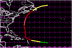
a. Synoptic HistoryOn 27 July a westward moving tropical wave emerged from the northwest coast of Africa, as detected in analyses of rawinsonde data from Dakar and in METEOSAT imagery. On 31 July the wave showed sufficient deep convection and a persistent enough cloud system center to be classified using the Dvorak technique by satellite analysts at the NHC. The weather system became the fifth tropical depression of the 1989 hurricane season near 0600 UTC on the 31st while located midway between the Lesser Antilles and the Cape Verde Islands. The depression generally moved westward near 17 mph, and based on satellite intensity estimates, attained tropical storm strength by 0600 UTC on 1 August. Tropical Storm Dean moved toward the west-northwest while continuing to strengthen, and was upgraded to a hurricane near 1200 UTC on 2 August immediately after the first report of hurricane force winds from an Air Force reconnaissance plane. By 3 August, Dean decreased in forward motion and turned toward the northwest, in response to a collapsing ridge to the north and a developing upper-level trough off the U.S. east coast. By 4 August, Dean turned more toward the north as the upper trough off the U.S. deepened. This northward direction of motion continued with an increase in forward speed to near 17 mph, bringing the eastern eyewall over the island of Bermuda near 1800 UTC on 6 August. This was the first time sustained hurricane force winds were recorded at Bermuda since Hurricane Emily passed over the island in 1987. The lowest pressure reported by reconnaissance aircraft was
970 mb, just after the hurricane passed Bermuda. However, after the last
aircraft penetrated the cyclone, the cloud pattern observed in satellite
imagery became even better organized with a well-defined eye embedded
within a small but cold central dense overcast. Based on satellite estimates,
the minimum pressure and maximum winds likely occurred near 0000 UTC on
7 August. b. Meteorological StatisticsAs the eastern eyewall passed over Bermuda, the highest sustained
wind reported was 81 mph with gusts to 113 mph at the U.S. Naval Annex
on the western end of the island. 1. Storm Surge DataAlthough the hurricane remained well offshore of the U.S.
east coast, tides of 1.7 feet above normal were reported on the Outer
Banks of North Carolina, and were apparently generated by swells from
Hurricane Dean.
| ||||||||||||||||||||||||
| Date/Time (UTC) |
Position | Pressure (mb) |
Wind Speed (mph) |
Stage | |
|---|---|---|---|---|---|
| Lat. (°N) | Lon. (°W) | ||||
| 07/0000 | 34.0 | 64.9 | 968 | 105 | Category 2 Hurricane |
Landfall for Hurricane
Dean
31 July - 09 August, 1989
| Date/Time (UTC) |
Pressure (mb) |
Wind Speed (mph) |
Stage | Landfall |
|---|---|---|---|---|
| 08/1300 | 991 | 65 | Extratropical Storm | Sable Island, Nova Scotia |