1991 PRELIMINARY
REPORTS
Tropical
Storm Ana (TS)
Hurricane Bob (3)
Hurricane Claudette (3)
Tropical Storm Danny (TS)
Tropical Storm Erika (TS)
Tropical Storm Fabian (TS)
Hurricane Grace (2)
|
a. Synoptic History
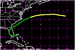
Ana, the first tropical cyclone of the 1991 hurricane season,
formed from a low to mid-level cyclone that developed downward to the
surface in the vicinity of the Bahamas.
A post-analysis of upper-air data, surface charts, and satellite imagery
revealed that the incipient stages of Ana may have begun as early as 1200
UTC 25 June 1991. At that time, there was a low at 850 mb and 700 mb about
275 nautical miles east of Jacksonville, Florida; a stationary front at
the surface oriented east-west near 30°N; and an anticyclone over
north Florida at upper levels. During the next several days, the low took
an anticylonically curving path toward the Bahamas. By 1200 UTC on 29
June, a small surface low was present embedded in a trough over the northern
Bahamas.
The trough with the embedded low continued moving westward across south
Florida, curving northward along Florida's west coast, and then northeastward
toward the St. Augustine area by 0000 UTC 2 July 1991. The low pressure
area was considered to weak to be classified (using the Dvorak technique)
as it emerged into the Atlantic by 1200 UTC, but by 1800 UTC the convection
was becoming better organized. It is estimated that Tropical Depression
One formed in this low pressure area when centered about 85 nautical miles
south of Charleston, South Carolina.
Within 12 hours, Tropical Depression One began accelerating toward the
northeast while maintaining a course offshore and parrallel to the coasts
of South and North Carolina. An Air Force Reserve reconnaissance plane
reached the system center at 1600 UTC 3 July but found only a weak circulation
with 35 mile winds at the 1500 feet flight level and a central pressure
of 1008 mb at the surface. However, NOAA buoy 41001 (34.9°N
72.9°W) at 1900 UTC 3 July, reported an 8.5 minute sustained wind
of 38 miles and a pressure of 1006. Thus, the maximum 1-minute sustained
wind was deemed to be of tropical storm force and a special statement
was issued by the National Hurricane Center at 2000 UTC indicating that
a tropical storm had formed, and the first advisory on Tropical Storm
Ana was issued at 2200 UTC.
Tropical Storm Ana began moving east northeastward near 29 miles while
approaching a quasi-stationary east-west frontal zone.
An unidentified ship located 20 nautical miles south of the center at
0900 UTC on the 4th estimated sustained winds of 52 miles. This was the
highest, sustained, surface wind speed reported for Ana.
Ana continued moving generally eastward, just south of the frontal zone
and lost its tropical characteristics by 1800 UTC 5 July 1991 over the
cold waters of the North Atlantic.
b. Meteorological Statistics
After becoming a tropical depression, Ana was primarily of
concern to the marine community. By the time it became a tropical storm,
the center was heading away from the east coast of the United States.
c. Casualty and Damage Statistics
There were no reports of damage, injuries, or deaths related
to Ana.
Maximum
Intensity For Tropical Storm Ana
29 June - 05 July, 1991
Date/Time
(UTC) |
Position |
Pressure
(mb) |
Wind Speed
(mph) |
Stage |
| Lat. (°N) |
Lon. (°W) |
| 07/1200 |
41.5 |
69.0 |
1002 |
40 |
Tropical Storm |
|