1991 PRELIMINARY
REPORTS
Tropical
Storm Ana (TS)
Hurricane Bob (3)
Hurricane Claudette (3)
Tropical Storm Danny (TS)
Tropical Storm Erika (TS)
Tropical Storm Fabian (TS)
Hurricane Grace (2)
|
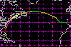
Hurricane Bob was the first hurricane to strike the
northeast United States since Hurricane
Gloria in 1985.
a. Synoptic History
Satellite imagery and synoptic analyses indicated that Bob
originated from the remnants of a frontal trough. Showers and thunderstorms
increased along this frontal trough just south and southeast of Bermuda
on 12 August. The area of disturbed weather moved toward the southwest
and west during the next few days. Surface analyses at 1200 and 1800 UTC
on 15 August indicated that a weak (1015 mb) low had formed within the
area of disturbed weather, a couple of hundred nautical miles to the east
of Bahamas. However, animation of high resolution visible satellite imagery
during that period revealed only a broad, poorly-defined cyclonic circulation
of low clouds near a band of convection with little curvature.
The area of disturbed weather was more organized on satellite
imagery the next day. In addition, a closed circulation at a flight level
of 1500 feet, and a maximum wind of 37 miles at 0143 UTC were reported
by the U.S. Air Force Reserve unit aboard the first reconnaissance flight
into the system. Based on these data, it is estimated that the area of
disturbed weather became the third tropical depression of the Atlantic
hurricane season at 0000 UTC on 16 August, while centered 175 nautical
miles east of Nassau in the Bahamas. Early-light visible satellite pictures
on the 16th showed further development, including a more-curved convective
band wrapping around the west and south quadrants of a well-defined low-level
cloud-system center that was moving west-northwest at about 6 miles.
Both the reconnaissance data near 1800 UTC on 16 August, which
included a 59 mile wind at the 1500-feet flight level and a surface pressure
of 1005 mb, and satellite intensity estimates from the NESDIS Synoptic
Analysis Branch (SAB) and the NHC support upgrading the depression to
Tropical Storm Bob at that time. Bob was then centered 120 nautical miles
northeast of Nassau. The storm continued strengthening and began moving
more toward the northwest under the influence of the deep layer mean flow.
On 17 August, satellite imagery showed increased convective
banding around a central dense overcast. An Air Force reconnaissance plane
at 1719 UTC encountered 82 mile winds at the 1500-feet flight level, and
a surface pressure of 987 mb was reported. The onboard Air reconnaissance
Weather Officer estimated surface winds at 75 miles. Based on these reports,
the best track shows that Bob strengthened to a hurricane at 1800 UTC
on the 17th, while centered 205 nautical miles east of Daytona Beach,
Florida. The hurricane began turning toward the north and then northeast
at an increasing forward speed. The steering flow was the result of the
combined effects of the subtropical high pressure ridge over the Atlantic
and a mid to upper-level trough over the southeastern united States.
Deep convection became more concentrated near the center of the hurricane
and a well-defined eye appeared in satellite pictures late on August 18.
Bob continued intensifying and the eye became even more distinct as it
passed 25 to 30 nautical miles east of Cape Hatteras early on the 19th.
An Air Force reconnaissance plane at 0412 UTC on 19 August encountered
137 mile winds at the 700 mb flight level. At 0621 UTC a surface pressure
of 950 mb was measured. These reports are the basis for showing the maximum
surface wind of 115 miles on the best track at 0600 UTC on the 19th while
Bob was located about 90 nautical miles east-southeast of Norfolk, Virginia.
Bob was a Category 3 hurricane on the Saffir/Simpson Hurricane Scale at
this time and was moving toward the north-northeast near 23 miles.
Bob continued to move toward the north-northeast, steered by the flow
between a mid to upper-level cut-off low near the Great Lakes, and a strong
Atlantic subtropical high pressure ridge. In this steering flow, Bob moved
parrellel to the United States mid-Atlantic coast and headed toward New
England on a track similar to the tracks of Hurricanes Carol and Edna
1954.
Bob weakened while accelerating the north-northeast over waters which
became significantly cooler off of the mid-Atlantic coast. The eye was
partially filled with clouds when it passed just east of Long Island,
New York. The west side of a weakened eyewall passed over Montauk Point
on the eastern tip of the island. The eye passed over Block Island at
1720 UTC and moved over Newport, Rhode Island near 1800 UTC. Aircraft
reconnaissance personnel were unable to report an eye just prior to this
landfall, because less than 50% of the center was surrounded by an eyewall.
By the time of landfall on Rhode Island, Bob was moving toward the north-northeast
at 32 miles with maximum sustained winds of a Category 2 hurricane.
Bob crossed Rhode Island and Massachusetts, with the center moving between
Boston and Scituate. It then moved over Massachusetts Bay. The hurricane
continued to weaken and began losing tropical characteristics as it passed
just offhore of the southern coast of Maine and made landfall as a tropical
storm near Rockland, Maineat at 0130 UTC on 20 August. Bob turned more
toward the northeast and crossed Maine and New Brunswick. Bob exited New
Brunswick near Chatham at 1200 UTC on the 20th and became extratropical
over the Gulf of St. Lawrence by 1800 UTC. It then crossed northern Newfoundland,
and the central North Atlantic along 50-55°N, before moving southeastward
and dissipating near the coast of Portugal on 29 August.
b. Meteorological Statistics
Air Force Reserve Unit aircraft provided most of the reconnaissance
on this hurricane from near the time of initial development into a tropical
depression east of the Bahamas, until just before final landfall on the
coast of Maine. A NOAA plane made a flight into Bob as the hurricane passed
the Outer Banks of North Carolina.
Table 2c lists selected hourly observations made by NOAA's National Data
Buoy Center (NDBC) platforms near the path of Bob. The NOAA buoys report
an 8-minute average sustained wind, and the Coastal-Marine Automated Network
(C-MAN) reports give 2-minute average sustained winds. The Diamond Shoals
Light C-MAN (35.2°N 75.3°W) reported a minimum pressure of 961
and maximum sustained winds of 98 miles with gusts to 112 miles at 0200
UTC on 19 August. The Buzzards Bay C-MAN (41.4°N 71.0°W) reported
a minimum pressure of 971 at 1800 UTC on 19 August and maximum sustained
winds of 77 miles with gusts to 89 miles at 1700 UTC. Since these were
reported hourly observations, they are likely not the extreme values which
occured at the sites. In fact, the continuous wind data from the Diamond
Shoals C-MAN received well after the event showed a peak gust of 123 miles.
The wind measurements from Block Island of 105 miles and 100 miles were
reported as peak gusts. However, both of these values were at the upper
limit of the equipment range and were reportedly maintained (and probably
exceeded) for a short period (< 1 minute). An observer on Block Island
reported the eye overhead at 1720 UTC on 19 August, with the approximate
duration of light winds from 30 to 40 minutes.
As the eye moved over Newport, the Navy Ship USS VALDEZ, anchored
in Narragansett Bay, reported a pressure of 964 mb at 1815 UTC on 19 August.
A cooperative observer in Adamsville, Rhode Island, just east of the track
reported a pressure of 964 mb at 1820 UTC. These values are close to the
965 mb pressure reported from an Air Force reconaissance plane at 1737
UTC just prior to the Newport landfall.
As Bob emerged over the cooler waters of Massachusetts Bay, the maximum
sustained surfcae winds continued to decrease. NOAA buoys 44013
(42.4°N 70.8°W) and 44007 (43.5°N 70.1°W),
along with the Mantinicus Rock (43.8°N 68.9°W) and Mt. Desert
Rock (44.0°N 68.1°W) C-MAN stations, all reported maximum sustained
winds below hurricane force, justifing the downgrading of Bob to tropical
storm before final landfall near Rockland, Maine.
1. Storm Surge Data
At the time of publication of this report a post-storm high
water mark survey was being conducted by the New England Division of the
U.S. Army Corps of Engineers. Initial survey results suggest that the
highest storm surge values occured in Massachusetts and Rhode Island,
where wind driven water was funneled into Buzzards and Narrangansett Bays.
Visual and measured high water marks, which contain both storm surge and
astronomical tide heights and in some cases the effects of breaking waves,
were also highest there. (Note: storm surge values derived from National
Ocean Survey (NOS) tide gages listed in Table 2a have the effects of tide
hight and wave effects removed). Specifically high water marks at the
upper end of Buzzards Bay ranged from 8.5 to 15.3 feet. Further south
on the east shore at Woods Hole a storm surge of 5.8 feet was calculated
from NOS tide gage data. Similarly, on the west shore of Buzzards Bay,
a storm surge of 5.8 feet was calculated from tide gage data at the New
Bedford hurricane barrier. In Rhode Island, high water marks between 10.2
and 16.5 feet were measured near Sakonnet Point. These values include
wave effects because of its exposure on the coast. A storm surge height
of 6.5 feet occurred ath the Providence hurricane barrier tide gage. This
gage, which is located at the west end of the Sound, had a storm surge
of 6.7 feet. The surge occurred almost 2 hours after landfall when the
hurricane was abeam of Boston.
2. Rainfall Data
Rainfall totals ranged up to nearly 8 inches along the path
of Bob. The largest totals include 5.3 inches at Cape Hatteras, 7.04 inches
at Bridgehampton (on Long Island), 7 inches at the Groton Emergency Operations
Center in Connecticut, 5.43 inches at Brimfield, Massachusetts, and 7.83
inches at Portland, Maine. Several rainfall amounts between 2 and 5 inches
occurred elsewhere over portions of New York and New England.
3. Tornadoes
Six confirmed tornadoes were reported in associated with
Bob, 4 in North Carolina and 2 in New York on Long Island. Thirteen additional
unconfirmed were reported, including 9 in wooded areas on Hatteras Island,
2 in Rhode Island, and 2 in Massachusetts.
c. Casualty and Damage Statistics
There were 17 deaths attributed to Bob; 6 in Connecticut,
3 in Maine, 2 in New York, 2 in New Hampshire, 2 in Nova Scotia, 1 South
Carolina and 1 in North Carolina.
The American Insurance Association preliminary estimate of
insured property damage for the United States is $782
Million. This includes $4 Million
for North Carolina, $75 Million for New York,
$40 Million for Connecticut, $115
Million for Rhode Island, $525 Million
for Massachusetts, $2 Million for New Hampshire,
and $21 Million for Maine. The addition of
flood claims, uninsured property damage, and the cost of cleanup increases
the total damage estimate from Bob to $1.5 Billion.
Without adjustments for inflation, Bob would rank 5th or 6th on the list
of 20th century United States hurricanes. With adjustments for inflation
Bob will rank 13th or 14th on that list. These damage figures make Bob
the most recent of a string of hurricanes that that were very costly to
the northeast United States. Other prominent, destructive hurricanes there
include Gloria
in 1985, Agnes in 1972, Donna in 1960, Diane in 1955, Carol in 1954, an
unnamed hurricane in 1944, and the New England Hurricane of 1938.
Power was knocked out to an estimated 2.1 million homes and businesses
primarily on the Outer Banks of North Carolina, on Long Island, and over
portions of New England.
Maximum Intensity For Hurricane
Bob
16 - 29 September, 1991
Date/Time
(UTC) |
Position |
Pressure
(mb) |
Wind Speed
(mph) |
Stage |
| Lat. (°N) |
Lon. (°W) |
| 19/0600 |
36.5 |
74.5 |
950 |
115 |
Category 3 Hurricane |
Landfall for Hurricane
Bob
16 - 29 September, 1991
Date/Time
(UTC) |
Pressure
(mb) |
Wind Speed
(mph) |
Stage |
Landfall |
| 19/1720 |
962 |
105 |
Category 2 Hurricane |
Block Island,
Rhode Island |
| 19/1800 |
964 |
100 |
Category 2 Hurricane |
Newport,
Rhode Island |
| 20/0130 |
964 |
70 |
Tropical Storm |
Rockland,
Maine |
|