|
|
|
|
|||||||||||||||
|---|---|---|---|---|---|---|---|---|---|---|---|---|---|---|---|
|
1991 PRELIMINARY
REPORTS |
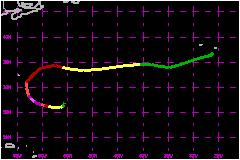
Hurricane Claudette developed over the subtropical Atlantic and, although small, was quite intense for a brief period. It spent its entire lifetime at sea. a. Synoptic HistoryClaudette was spawned from a disturbance of non-tropical origin. An upper-tropospheric disturbance with an associated area of scattered convection was noted several hundred miles east of the northeast coast of Florida on 1 September. This system moved generally eastward and passed Bermuda on 2 September. A low-level vorticity maximum, apparently induced by the upper level system, became quasi-stationary about 500 nautical miles southeast of Bermuda on 3 September while the upper-level impulse continued moving eastward out of the area. On that same date a cold front, moving southward over the western Atlantic, approached the low-level disturbance but did not overtake it. The convection associated with the disturbance increased and became concentrated near 27°N 57°W by 0000 UTC on 4 September. The frontal system became weak and diffuse, while the convection associated with the disturbance became organized into a pattern of two hooking bands by 1200 UTC on 4 September. This prompted satellite classifications by both the NHC and the Synoptic Analysis Branch (SAB) of T1.0 and T1.5, respectively. The cloud pattern continued to become better organized in satellite imagery, and it is estimated that a tropical depression formed by 1800 UTC on 4 September. Satellite classifications were T2.0 from both NHC and SAB at that time. Little movement was detected. Development was steady, and Claudette became a tropical storm by 1200 UTC 5 September, while commencing a slow southwestward motion. The upper tropospheric environment was favourable for continued strengthening, with a large anticyclone located over the area and a digging trough to the east. These features created an efficient outflow mechanism, and Claudette deepened at a fastern than normal rate. Hurricane intensity was reached shortly after 0600 UTC on 6 September, based on satellite intensity estimates from NHC. Claudette, now moving westward, continued to strengthen rapidly. When the first reconnaissance flight was made into the cyclone, by an Air Force Reserve unit plane shortly after 1800 UTC on 6 September, it was found to be a strong hurricane with a central pressure of 965 mb and maximum surface winds estimated near 115 miles. This compared fairly well with concurrent satellite intensity estimates from NHC of 970 mb and 104 miles. A well-defined eye had appeared on visible imagery several hours earlier. Claudette was a compact cyclone; the eye diameter was found to be near 7 nautical miles during the first aircraft penetration and hurricane force winds extended outward only about 20 nautical miles from the center at flight level (850 mb). By this time, the hurricane had turned to the west northwest as it moved around the periphery of a 500 mb anticyclone. There was no aircraft reconnaissance of Claudette during the period between 2016 UTC on 6 September and 1610 UTC on 7 September. On the basis of satellite-derived intensity estimates, the hurricane reached its peak intensity during this time period. The three-hourly averaged objective Dvorak T number reached a maximum of 6.2 near 1000 UTC on 7 September. This equates to a central pressure just below 945 mb. Post-analysis of the formal six-hourly Dvorak satellite classifications from NHC reveals that at 1200 UTC on 7 September, the final T number and current intensity number were 6.0, which implies a central pressure of 948 mb and maximum winds of 132 miles at that time. It is informative to note that a "ground-truth" comparison of the Dvorak intensity estimates with the aircraft measurements made at the beginning and at the end of Claudette's most intense period revealed that the satellite technique provided a fairly good estimate of intensity. Therefore, it is likely that Claudette was the strongest storm of the Atlantic season thus far. The mimumum central pressure estimate, 944 mb at 1000 UTC, implies that considerable filling occured during the subsequent six hours, up to the time of the next aircraft penetration, when the NOAA research plane indicated a pressure of 959 mb. This rate of filling, although large, is not unprecendented. For instance, Hurricane Allen of 1980 filled even more rapidly over water during several periods of its lifetime. After 1600 UTC on 7 September, Claudette weakened steadily
but at a more gradual rate. The hurricane turned northwest, then northward
by 1200 UTC on 8 September. At that time, a short-wave trough at 500 mb
moved off the U.S. east coast. Under this steering influence, Claudette
continued turning clockwise during the day, and was northeastward with
increasing forward speed by 0600 UTC on 9 September. The hurricane passed
about 110 nautical miles east southeast of Bermuda at its closest approach
to that island on the evening of 8 September. Bermuda experienced no significant
effects from Claudette. The hurricane turned to the east northeast during
the day on 9 September. It then dropped east southeast the following night
while weakening to a tropical storm, losing most of its deep convection.
This east-southeastward motion was likely due in part to the influence
of the circulation of Tropical Storm Erika,
which was centered a few hundred miles to the east southeast at the time.
The storm continued to weaken while accelerating in a general eastward
direction, until it dropped below tropical storm strength around 1800
UTC on September 11. Claudette then decelerated but became extratropical
while located a few hundred miles west southwest of the Azores. The weak
low moved toward the Azores, dissipating in the vicinity of those islands
around 1800 UTC on September 14. b. Meteorological StatisticsThe highest sustained winds at Bermuda were only about 23 miles
with gusts to 32 miles, and a few showers occured there as the fringes
of the hurricane passed over on the afternoon of 8 September. Several
reports of near-tropical storm force winds were received from ships which
came near to Claudette. A Turkish Vessel, the "Mar Transporter
II", located about 120 nautical miles south southeast of the
center reported winds of 240°/38 miles and a pressure of 1014 mb
at 1800 UTC on 9 September. A ship, whose call sign is not known, located
about 20 nautical miles south of the center, reported winds 260°/52
miles and pressure 1002 mb at 0900 UTC on 10 September. A Dutch Ship,
the "Beursgracht", located about 120 nautical miles southwest
of the center reported winds 290°/46 miles and pressure 1015 at 0900
UTC on 10 September. A British pleasure ship, the "Allegro",
reported winds 360°/43 miles and pressure 1013 while located about
60 nautical miles southwest of the center at 1200 UTC on 11 September.
That same ship reported a 1009 mb pressure 6 hours earlier when it was
40 nautical miles north of the center, but only 23-mile winds at the time. c. Casualty and Damage StatisticsNo reports of casualties or damage due to Claudette have been received.
Maximum
Intensity For Hurricane Claudette
| ||||||||||||||