|
|
|
|
||||||||||||||||||||||||||||||
|---|---|---|---|---|---|---|---|---|---|---|---|---|---|---|---|---|---|---|---|---|---|---|---|---|---|---|---|---|---|---|
|
1991 PRELIMINARY
REPORTS |
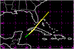
a. Synoptic HistoryTropical Storm Fabian had a typical October western Caribbean
development. A cold front moved into the northwest Caribbean on 12 October
and produced northeasterly winds and showers over Florida and Cuba. At
that time, a tropical wave with its axis near Jamaica was moving slowly
westward. On 13 October the front and the tropical wave interacted in
the Gulf of Honduras. Surface reports indicated that pressure began to
fall over the coast of Honduras while satellite images showed an increase
in convective activity. b. Meteorological StatisticsSurface observations at Cayo Largo, along the south coast
of central Cuba indicated a wind shift from east-southeast to south, with
gusts to 40 miles and a drop in pressure from 1012 mb to 1008 mb in 6
hours as the center of Fabian passed just to the west of that location.
La Fe on the northern portion of Isle of Youth, reported a minimum pressure
of 1005 mb at 2100 UTC on the 15th when Fabian was crossing that island. 1. Rainfall DataThe primary impact of Fabian on cuba was rainfall of more
than 4 inches during a 12 to 24 hour period on the 15th over the central
part of the island. The highest reported rainfall was 6.2 inches at Caonao,
near Cienfuegos on the south coast of central Cuba. Large rainfall accumulations
were also reported at the following central Cuba locations. Antonio Maceo
(5.7 inches), Punta del Este (5.5 inches), and Calimete, Matanzas (4.7
inches). Five of the total of 5.5 inches of rain at Punta del Este were
received during a 6 hour period as Fabian moved over that region. c. Casualty and Damage StatisticsNo reports of casualties or damages associated with Fabian were received by the NHC.
Maximum Intensity For Tropical
Storm Fabian
Landfall for Tropical
Storm Fabian
| |||||||||||||||||||||||||||||